Janakpur Zone facts for kids
Quick facts for kids
Janakpur
जनकपुर अञ्चल
|
|
|---|---|
 |
|
| Country | Nepal |
| Region | Eastern Development Region |
| Area | |
| • Total | 9,669 km2 (3,733 sq mi) |
| Population
(2001)
|
|
| • Total | 2,557,004 |
| • Density | 264.5/km2 (685/sq mi) |
| Time zone | UTC+5:45 (Nepal Time) |
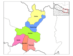
Janakpur (Nepali: जनकपुर अञ्चल) was one of the 14 special areas, called zones, in Nepal. It stretched from the border with India in the south all the way to the Tibetan border in the north. To its east was Sagarmatha Zone, and to its west were Bagmati and Narayani Zones.
The main city and capital of Janakpur Zone was Janakpur. This city is very old and important, especially for people who follow Hinduism. Many people believe it was once the capital city of King Janak. King Janak was the father-in-law of Lord Rama, a famous prince from Ayodhya. The whole zone was named after King Janak and his city, Janakpur.
Other towns in Janakpur Zone included Kamalamai (in the Inner Terai) and places like Bhimeshwor, Bardibas, Dhalkebar, Jaleshwor, Malangwa, Gaushala Bazar, and Matihani (in the Outer Terai).
Districts of Janakpur Zone
Janakpur Zone was divided into six smaller areas called districts. Each district had its own main town or "headquarters." These districts helped manage the different parts of the zone.
| District | Type of Land | Headquarters |
|---|---|---|
| Dhanusa District | Outer Terai | Janakpur |
| Dolakha District | Mountain | Charikot |
| Mahottari District | Outer Terai | Jaleshwar |
| Ramechhap District | Hill | Manthali |
| Sarlahi District | Outer Terai | Malangwa |
| Sindhuli District | Inner Terai | Kamalamai |
Related Pages
See also
 In Spanish: Zona de Janakpur para niños

