Jonesboro, Georgia facts for kids
Quick facts for kids
Jonesboro, Georgia
|
|||||
|---|---|---|---|---|---|

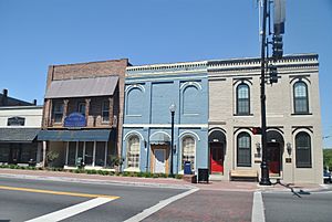
Buildings in the Jonesboro Historic District
|
|||||
|
|||||

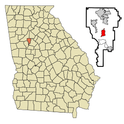
Location in Clayton County and the state of Georgia
|
|||||
| Country | United States | ||||
| State | Georgia | ||||
| County | Clayton | ||||
| Area | |||||
| • Total | 3.00 sq mi (7.76 km2) | ||||
| • Land | 2.98 sq mi (7.71 km2) | ||||
| • Water | 0.02 sq mi (0.05 km2) | ||||
| Elevation | 919 ft (280 m) | ||||
| Population
(2020)
|
|||||
| • Total | 4,235 | ||||
| • Density | 1,422.10/sq mi (549.16/km2) | ||||
| Time zone | UTC-5 (Eastern (EST)) | ||||
| • Summer (DST) | UTC-4 (EDT) | ||||
| ZIP codes |
30236-30238
|
||||
| Area code(s) | 770/678/470 | ||||
| FIPS code | 13-42604 | ||||
| GNIS feature ID | 0332118 | ||||
Jonesboro is a city in Georgia, United States. It is the main city, or county seat, of Clayton County. In 2020, about 4,235 people lived there.
The city was first called Jonesborough. During the American Civil War, a very important battle happened near Jonesboro in 1864. This battle, called the Battle of Jonesborough, helped end the Atlanta Campaign. It led to the city of Atlanta surrendering. This event was a big turning point in the war. It also helped Abraham Lincoln get re-elected as president. The war ended the next year.
Contents
History of Jonesboro
Jonesboro was settled by people as early as 1821. It was first named Leaksville in 1823. A church called Flint River Baptist Church was built there in 1825.
In 1846, a railroad called the Macon and Western Railroad came to the area. The town was then renamed Jonesboro. This was to honor Samuel G. Jones, an important railroad official. Jonesboro officially became a city in 1859.
Jonesboro was a host city for the 1996 Summer Olympics. It held the beach volleyball games at Clayton County International Park. In March 2023, Dr. Sonya Sartor became the first Black Mayor of Jonesboro.
Geography and Climate
Jonesboro is located at 33°31′28″N 84°21′15″W / 33.52444°N 84.35417°W.
The city covers about 2.6 square miles (7.76 square kilometers). Most of this area is land, with a small part being water.
The railroad that runs through Jonesboro is built on the Eastern Continental Divide. This means it's on a high point where water flows in different directions. There are no bridges for the tracks for many miles around.
Jonesboro's Weather
Jonesboro has a climate with warm summers and mild winters. The warmest month is July, and the coldest is January. It gets a good amount of rain throughout the year.
| Climate data for Jonesboro, Georgia, 1991–2020 normals, extremes 1994–present | |||||||||||||
|---|---|---|---|---|---|---|---|---|---|---|---|---|---|
| Month | Jan | Feb | Mar | Apr | May | Jun | Jul | Aug | Sep | Oct | Nov | Dec | Year |
| Record high °F (°C) | 77 (25) |
81 (27) |
89 (32) |
92 (33) |
95 (35) |
103 (39) |
104 (40) |
104 (40) |
99 (37) |
98 (37) |
86 (30) |
78 (26) |
104 (40) |
| Mean maximum °F (°C) | 69.7 (20.9) |
73.6 (23.1) |
80.7 (27.1) |
85.3 (29.6) |
90.4 (32.4) |
95.9 (35.5) |
96.1 (35.6) |
95.9 (35.5) |
92.5 (33.6) |
82.8 (28.2) |
76.8 (24.9) |
72.6 (22.6) |
97.7 (36.5) |
| Mean daily maximum °F (°C) | 52.7 (11.5) |
56.5 (13.6) |
64.7 (18.2) |
73.0 (22.8) |
80.5 (26.9) |
86.7 (30.4) |
89.6 (32.0) |
88.6 (31.4) |
83.2 (28.4) |
73.4 (23.0) |
62.4 (16.9) |
54.7 (12.6) |
72.2 (22.3) |
| Daily mean °F (°C) | 42.5 (5.8) |
45.9 (7.7) |
53.3 (11.8) |
61.0 (16.1) |
69.7 (20.9) |
76.6 (24.8) |
79.8 (26.6) |
78.8 (26.0) |
73.3 (22.9) |
62.5 (16.9) |
51.7 (10.9) |
45.1 (7.3) |
61.7 (16.5) |
| Mean daily minimum °F (°C) | 32.3 (0.2) |
35.3 (1.8) |
41.8 (5.4) |
49.1 (9.5) |
58.8 (14.9) |
66.5 (19.2) |
70.0 (21.1) |
69.0 (20.6) |
63.3 (17.4) |
51.6 (10.9) |
40.9 (4.9) |
35.4 (1.9) |
51.2 (10.7) |
| Mean minimum °F (°C) | 17.1 (−8.3) |
22.3 (−5.4) |
28.6 (−1.9) |
36.3 (2.4) |
45.9 (7.7) |
58.2 (14.6) |
63.4 (17.4) |
63.5 (17.5) |
53.1 (11.7) |
37.1 (2.8) |
27.7 (−2.4) |
24.0 (−4.4) |
15.9 (−8.9) |
| Record low °F (°C) | 5 (−15) |
6 (−14) |
14 (−10) |
29 (−2) |
37 (3) |
50 (10) |
52 (11) |
57 (14) |
42 (6) |
29 (−2) |
19 (−7) |
7 (−14) |
5 (−15) |
| Average precipitation inches (mm) | 5.02 (128) |
4.86 (123) |
4.95 (126) |
4.19 (106) |
3.47 (88) |
4.59 (117) |
5.09 (129) |
4.42 (112) |
3.56 (90) |
3.62 (92) |
4.19 (106) |
4.96 (126) |
52.92 (1,343) |
| Average snowfall inches (cm) | 0.5 (1.3) |
0.0 (0.0) |
0.1 (0.25) |
0.0 (0.0) |
0.0 (0.0) |
0.0 (0.0) |
0.0 (0.0) |
0.0 (0.0) |
0.0 (0.0) |
0.0 (0.0) |
0.0 (0.0) |
0.2 (0.51) |
0.8 (2.06) |
| Average precipitation days (≥ 0.01 in) | 10.5 | 10.6 | 9.7 | 8.5 | 8.3 | 10.8 | 11.2 | 10.2 | 7.9 | 6.8 | 8.2 | 10.4 | 113.1 |
| Average snowy days (≥ 0.1 in) | 0.3 | 0.0 | 0.0 | 0.0 | 0.0 | 0.0 | 0.0 | 0.0 | 0.0 | 0.0 | 0.0 | 0.1 | 0.4 |
| Source 1: NOAA | |||||||||||||
| Source 2: National Weather Service (mean maxima/minima 2006–2020) | |||||||||||||
People of Jonesboro (Demographics)
The population of Jonesboro has changed over the years. Here's how it has grown and shrunk:
| Historical population | |||
|---|---|---|---|
| Census | Pop. | %± | |
| 1870 | 531 | — | |
| 1880 | 1,048 | 97.4% | |
| 1890 | 803 | −23.4% | |
| 1900 | 877 | 9.2% | |
| 1910 | 970 | 10.6% | |
| 1920 | 1,060 | 9.3% | |
| 1930 | 1,065 | 0.5% | |
| 1940 | 1,204 | 13.1% | |
| 1950 | 1,741 | 44.6% | |
| 1960 | 3,014 | 73.1% | |
| 1970 | 4,105 | 36.2% | |
| 1980 | 4,132 | 0.7% | |
| 1990 | 3,635 | −12.0% | |
| 2000 | 3,829 | 5.3% | |
| 2010 | 4,724 | 23.4% | |
| 2020 | 4,235 | −10.4% | |
| U.S. Decennial Census | |||
In 2020, there were 4,235 people living in Jonesboro. They lived in 1,195 households, with 771 of these being families.
Here's a look at the different groups of people living in Jonesboro in 2020:
| Race | Num. | Perc. |
|---|---|---|
| White (non-Hispanic) | 1,126 | 26.59% |
| Black or African American (non-Hispanic) | 2,247 | 53.06% |
| Native American | 6 | 0.24% |
| Asian | 124 | 2.93% |
| Pacific Islander | 3 | 0.07% |
| Other/Mixed | 146 | 3.45% |
| Hispanic or Latino | 583 | 13.77% |
Transportation in Jonesboro
Jonesboro has public transportation options. Buses from MARTA and Xpress GA/Georgia RTA serve the city. These help people get around.
Jonesboro in Movies and Books
Jonesboro has been featured in several movies and books!
- Parts of the 1977 film Smokey and the Bandit were filmed here.
- Another 1977 movie, In Hot Pursuit, was also filmed in and around Jonesboro.
- In Margaret Mitchell's famous novel Gone with the Wind, the fictional plantation called Tara was located about five miles outside of Jonesboro. This made Jonesboro the closest town to the story's main setting.
- The movie "We Are Marshall" was briefly filmed at Tara Stadium in Jonesboro.
- The cover of Lynyrd Skynyrd's album (pronounced 'lĕh-'nérd 'skin-'nérd) was photographed near Mill and Main streets in Jonesboro.
Famous Places (Landmarks)
- Rural Home (no longer standing)
- Stately Oaks
Education in Jonesboro
Public schools in Jonesboro are run by Clayton County Public Schools.
Notable People from Jonesboro
Many interesting people have connections to Jonesboro:
- Dan T. Cathy (born 1953), the CEO of Chick-fil-A.
- Chidi "Chi Chi" Osondu, a Nigerian-American music producer and songwriter.
- Tashard Choice, a former running back in the National Football League (NFL).
- Harry Douglas, a former NFL wide receiver.
- Toney Douglas (born 1986), a basketball player.
- Jesse Fuller, an Afro-American blues musician.
- Sister Mary Melanie Holliday, a Catholic nun.
- Garrett Liberty, a racing driver.
- Steve Lundquist, who won two gold medals in swimming at the 1984 Summer Olympics.
- Johnny Nave, a racing driver.
- Thomas Milton Rivers, a bacteriologist and virologist who worked at the Rockefeller Institute. He was also a Rear Admiral in the U.S. Navy.
- Adam Smith (born 1992), a basketball player.
- Annie Fitzgerald Stephens, a landowner and businesswoman. She was the grandmother of author Margaret Mitchell.
- Cameron Sutton, a cornerback for the Detroit Lions in the NFL.
- M. J. Walker, a shooting guard who played for Florida State.
See also
 In Spanish: Jonesboro (Georgia) para niños
 | DeHart Hubbard |
 | Wilma Rudolph |
 | Jesse Owens |
 | Jackie Joyner-Kersee |
 | Major Taylor |


