
Juliaca facts for kids
Quick facts for kids
Juliaca
Hullaqa
|
|||
|---|---|---|---|
      |
|||
|
|||
| Nickname(s):
Ciudad de Los Vientos (The Windy City)
|
|||

Juliaca
Location in Peru
|
|||
| Country | Peru | ||
| Region | Puno | ||
| Province | San Román | ||
| District | Juliaca | ||
| Founded | 1630 | ||
| Incorporated | 3 October 1908 | ||
| Government | |||
| • Type | Democracy | ||
| Area | |||
| • Total | 533.47 km2 (205.97 sq mi) | ||
| Elevation | 3,825 m (12,549 ft) | ||
| Population
(2017)
|
|||
| • Total | 276,110 | ||
| • Estimate
(2015)
|
273,882 | ||
| • Density | 517.574/km2 (1,340.51/sq mi) | ||
| Time zone | UTC-5 (PET) | ||
| • Summer (DST) | UTC-5 (PET) | ||
| Area code(s) | +51 | ||
| Website | Official Website: http://www.munisanroman.gob.pe/ | ||


Juliaca is a big city in southeastern Peru. It is the capital of San Román Province in the Puno Region. With over 276,000 people, it is the largest city in its region.
Juliaca is located on a high plain called the Altiplano. It sits about 3,825 meters (12,549 feet) above sea level. The city is northwest of Lake Titicaca, which is about 45 kilometers (28 miles) away. Juliaca is also the main trading center in the Puno region.
The city is close to Chachas Lake and the Maravillas River. You can also find the ancient ruins of Sillustani nearby.
Juliaca is famous for its yearly Juliaca's Carnival, which happens between February and March. People dress in colorful costumes and dance in the streets. Another important event is Saint Sebastian's feast, celebrated every year on January 20.
People in Juliaca travel by cars, trains, and bicycles. The city is a key travel spot, connecting to other major cities in southern Peru like Arequipa, Puno, Tacna, Cuzco, and Ilo. It also has links to La Rinconada and Bolivia.
Juliaca is known as "The Windy City" because of its location on the windy Collao Plateau. It's also called the "Sock City" or "Knitting City." This is because Juliaca used to be a big center for making socks, sweaters, and other handmade items. Today, clothing, wool, and fabrics are made using industrial processes.
Juliaca is also home to Inca Manco Capac Airport, the main airport for the region.

Contents
What Does the Name Juliaca Mean?
Historians have different ideas about where the name Juliaca comes from.
The "Drizzle" Idea
One historian, Ramon Rios, thinks Juliaca comes from the Quechua words Xullaskca kaipi. This means "it had drizzled." He says that when Inca soldiers were chasing the Collas on the Altiplano, they noticed it had drizzled on the Huaynarroque hill.
The "Dew on Rocks" Idea
Another person, Justo Ruelas, believes Juliaca comes from the Quechua words Shulla Qaqa. This means "dew on rocks." He says that near the Huaynarroque and Santa Cruz hills, you can see small shiny quartz particles. These look like morning dew on rocks.
A Look Back: Juliaca's History
Juliaca has a long and interesting history, going back thousands of years.
Early People in Juliaca
The Altiplano, where Juliaca is, has been home to people since about 4,000 BC. These early communities lived in one place and focused on farming and raising animals like llamas and guinea pigs.
The Uros people lived near rivers and lakes, using plants like totora and fishing for food. They settled around lakes like Chacas, Qoriwata, Cochapampa, and the Juliaca River (now the Coata River). The Uros were skilled at sailing on rafts made of totora. These rafts helped them fish and travel between Lake Titicaca and smaller lakes.
Ancient Cultures and Empires
Between 1000 and 500 BC, Juliaca grew under the influence of the Qaluyo culture. Archaeologists found an old village from this time. The people there ate potatoes, quinoa, and kañiwa, and raised guinea pigs. They were also the first to build waruwarus (raised fields) and create special textiles.
Later, from 200 BC to 200 AD, the Pukara culture became powerful in this highland region. After that, the Huaynarroque tribe thrived. Over time, the great empires of Tiahuanaco, Colla, and Inka ruled the area. The Collas and Inkas were strong rivals. The Inkas, led by Pachacútec and his son Mayta Capac, finally took control after many battles.
Juliaca's Economy: A Trading Hub
Juliaca is a very important center for buying and selling goods and services. It is seen as the financial heart of the Puno region.
Trading is the main way people make a living here. About 26.5% of all workers in Juliaca are involved in trade. In 2008, Juliaca had over 15,000 businesses, which was 41% of all trade in the Puno region. It is also a key trading point for the high-altitude city of La Rinconada, where people mine for gold.
Because of all this business, Juliaca has seen a lot of money invested. This has helped reduce poverty and increase the income for some people living in the city.
Juliaca's Climate and Weather
Juliaca has a subtropical highland climate. This means it has cool to cold temperatures for most of the year. It's also close to an alpine climate, which is like a cold mountain climate.
The city gets about 610 millimeters (24 inches) of rain each year. Winters are dry, with cold nights and mornings, but pleasant afternoons.
| Climate data for Juliaca, elevation 3,838 m (12,592 ft), (1991–2020 normals, extremes 1961–present) | |||||||||||||
|---|---|---|---|---|---|---|---|---|---|---|---|---|---|
| Month | Jan | Feb | Mar | Apr | May | Jun | Jul | Aug | Sep | Oct | Nov | Dec | Year |
| Record high °C (°F) | 30.4 (86.7) |
26.0 (78.8) |
23.8 (74.8) |
27.0 (80.6) |
23.0 (73.4) |
21.8 (71.2) |
21.5 (70.7) |
22.1 (71.8) |
24.0 (75.2) |
24.0 (75.2) |
25.5 (77.9) |
27.2 (81.0) |
30.4 (86.7) |
| Mean daily maximum °C (°F) | 17.2 (63.0) |
16.9 (62.4) |
17.3 (63.1) |
17.7 (63.9) |
17.6 (63.7) |
17.1 (62.8) |
16.8 (62.2) |
17.8 (64.0) |
18.6 (65.5) |
19.1 (66.4) |
19.9 (67.8) |
18.6 (65.5) |
17.9 (64.2) |
| Daily mean °C (°F) | 10.9 (51.6) |
10.9 (51.6) |
10.6 (51.1) |
9.5 (49.1) |
7.1 (44.8) |
5.3 (41.5) |
4.9 (40.8) |
6.1 (43.0) |
8.2 (46.8) |
9.7 (49.5) |
10.8 (51.4) |
11.1 (52.0) |
8.8 (47.8) |
| Mean daily minimum °C (°F) | 4.5 (40.1) |
4.8 (40.6) |
3.8 (38.8) |
1.2 (34.2) |
−3.5 (25.7) |
−6.5 (20.3) |
−7.0 (19.4) |
−5.7 (21.7) |
−2.3 (27.9) |
0.3 (32.5) |
1.6 (34.9) |
3.5 (38.3) |
−0.4 (31.2) |
| Record low °C (°F) | −4.8 (23.4) |
−3.0 (26.6) |
−5.0 (23.0) |
−7.2 (19.0) |
−12.4 (9.7) |
−12.0 (10.4) |
−12.2 (10.0) |
−12.0 (10.4) |
−7.8 (18.0) |
−5.6 (21.9) |
−6.0 (21.2) |
−5.2 (22.6) |
−12.4 (9.7) |
| Average precipitation mm (inches) | 126.3 (4.97) |
119.0 (4.69) |
95.8 (3.77) |
39.5 (1.56) |
6.1 (0.24) |
2.3 (0.09) |
5.0 (0.20) |
5.2 (0.20) |
21.8 (0.86) |
51.1 (2.01) |
42.3 (1.67) |
104.7 (4.12) |
619.1 (24.38) |
| Source 1: National Meteorology and Hydrology Service of Peru | |||||||||||||
| Source 2: Meteo Climat (record highs and lows) | |||||||||||||
Places to See in Juliaca
Juliaca and its surrounding areas have many interesting places to visit. These include historical sites and natural spots. Some of the most popular are the Santa Catalina Church, Waynaruqi hill, Chacas Lagoon, and the Kokan community.
Santa Catalina Church

This church is in the main square, Plaza de Armas. It has a beautiful style called indigenous baroque. Building started in 1649 by the Jesuits, but it took 125 years to finish! It has only one bell tower, made from stone brought from Arequipa. Today, the Franciscan Order takes care of the church.
La Merced Church
This church is a lovely building from the time of the republic. It's on the west side of Plaza Bolognesi in the city center. It's made of red limestone and has a modern structure with an iron frame. Like the Santa Catalina Church, it has one bell tower and a clock with four faces. People who believed in the church asked Don Gregorio Layme to build it. It opened in 1959 and was updated in 1995, adding local elements.
Franciscan Convent
Also known as the Convent of Santa Bárbara, this building has four levels. It's built on the Hatun Rumi or Santa Bárbara hill, just 40 meters (131 feet) from Juliaca's Plaza de Armas. It has a Romanesque style. Because it was so important in the past, it's now one of the main places tourists visit in the city.
Waynaruqi Hill and the White Christ

This hill is southeast of the Plaza de Armas. At the top, you can see the White Christ statue, which is made of concrete and fiberglass. At the base of the statue, there's a viewpoint. From here, you can see all over Juliaca, both the city and the areas around it. The whole complex was built very quickly, in just two and a half weeks, and opened in 1987.
Las Calceteras Gallery

This is a three-story building on the north side of Plaza Bolognesi. It's a shopping center where you can find many handmade crafts. They sell all kinds of clothes like socks, hats (chullos), booties, shawls, sweaters, rugs, and gloves. These items are woven or made from local materials like llama, alpaca, and vicuña wool. You can also watch the artisan ladies, dressed in their traditional clothes, making these items by hand. Their wool and fiber products are very popular around the world.
Chacas Lagoon

Chacas Lagoon is about 10 kilometers (6 miles) northwest of Juliaca, near the towns of Kokan and Chacas. It's a lake surrounded by large hills, including Iquinito, which is the highest in the area. The lagoon is shaped like a spindle and covers about 6.2 square kilometers (2.4 square miles). This lake is full of local flora (plants) and fauna (animals), especially during the summer rainy season.
Images for kids
-
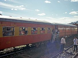
1980's Train in Juliaca
-
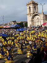
Juliaca's Carnival
-
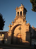
La Merced church
-
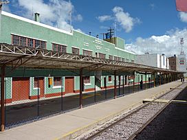
Juliaca Train Station
-
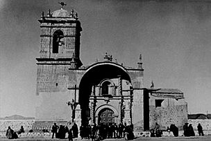
Santa Catalina Church in 1940
-
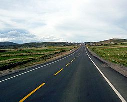
Road to Puno
-
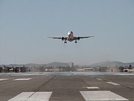
Inka Manqu Qhapaq Airport
-
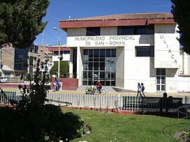
Juliaca's Prefecture


See also
 In Spanish: Juliaca para niños
