Junction City, Wisconsin facts for kids
Quick facts for kids
Junction City, Wisconsin
|
|
|---|---|
|
Village
|
|

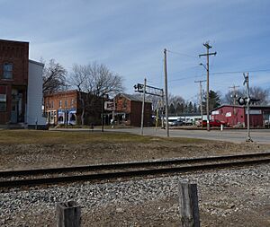
Old buildings around the town's main junction
|
|

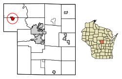
Location of Junction City in Portage County, Wisconsin.
|
|
| Country | |
| State | |
| County | Portage |
| Area | |
| • Total | 1.52 sq mi (3.92 km2) |
| • Land | 1.51 sq mi (3.90 km2) |
| • Water | 0.01 sq mi (0.02 km2) |
| Elevation | 1,145 ft (349 m) |
| Population
(2010)
|
|
| • Total | 439 |
| • Estimate
(2019)
|
439 |
| • Density | 291.11/sq mi (112.43/km2) |
| Time zone | UTC-6 (Central (CST)) |
| • Summer (DST) | UTC-5 (CDT) |
| Zip code |
54443
|
| Area code(s) | 715 & 534 |
| FIPS code | 55-38650 |
| GNIS feature ID | 1567317 |
Junction City is a small village in Portage County, Wisconsin, United States. In 2010, about 439 people lived there. It's known for being a place where two important railroad lines once met.
Contents
History of Junction City
How the Village Started
Junction City began in 1872 because of railroads. The Wisconsin Central Railroad built tracks west from Stevens Point. These tracks went through thick forests and swamps. Their goal was to reach Lake Superior.
Then, in 1874, another railroad, the Wisconsin Valley Railroad, built a line north from Centralia (now Wisconsin Rapids) to Wausau. This new line crossed the Wisconsin Central tracks. Where the two lines met, trains could switch tracks. Soon, a small community started to grow there. In 1874, a post office opened, and the place was simply called Junction.
Early Growth and Businesses
By 1876, Junction City was growing fast. Just a year before, it only had two small log cabins. But in 1876, it had two train stations (called depots), two sawmills, a hotel, a boarding house, a saloon, three homes, and a school. One sawmill might have also had a company store. The hotel was named the Junction City Hotel & Billiard Hall.
An old map from 1895 shows the two depots. One of them was also a hotel. There was another hotel nearby called Voyer House. The post office, a school, and the town hall were on what is now Main Street, a bit away from the train crossing. By this time, the village also had several stores. People were still cutting down trees in the area. The land was left with many tree stumps, which were sold to farmers. These farmers often worked as loggers in the winter.
Graphite Mining and Other Industries
In the 1890s, a mineral called graphite was found near Junction City. Graphite is used to make things like pencil lead and lubricants. It was mined from an underground mine about 70 feet deep. The graphite was then processed in a crushing mill about a mile northwest of the village. This plant could produce several tons of finished paint and paste product each day. The graphite business faced many challenges, including fires and a strong storm, before it finally closed in 1921.
In 1911, the community officially became a village and was named Junction City. That year, records showed the village had eight horses, twelve cows, and nine carriages. There were no cars yet! In the early 1900s, Junction City also had four potato warehouses. These warehouses helped the potato farmers in the nearby Town of Carson.
Changes Over Time
A map from 1915 shows that the two railroad lines now shared one depot. Many businesses were lined up along the west side of the Chicago, Milwaukee and St. Paul Railroad tracks. These included a saloon, an office, the post office, a blacksmith shop, and a lunch room. Other businesses were spread out, like the Junction City State Bank, two creameries (places that make butter and cheese), two factories, the school, a store, and several warehouses.
Fires caused a lot of damage to businesses over the years. Before 1923, people tried to put out fires with informal bucket brigades. But in 1923, a volunteer fire department was started. They had a cart pulled by hand and special chemical tanks to fight fires.
By 1958, trains still went through Junction City. However, U.S. Route 10 ran through Main Street, and trucks and cars were becoming more popular than train travel. The village had added more general stores, gas stations, garages, and a weekly newspaper called the Community Press. Much of the land around the village had changed from stump fields to dairy farms.
Around 2012, Highway 10 was moved to go north of Junction City. This meant less traffic now goes through the village center.
Geography of Junction City
Junction City is located at 44°35′29″N 89°45′52″W / 44.59139°N 89.76444°W. This is its exact spot on a map.
The United States Census Bureau says the village covers about 1.57 square miles (4.07 square kilometers) in total. Most of this area, about 1.56 square miles (4.04 square kilometers), is land. A very small part, about 0.01 square miles (0.03 square kilometers), is water.
Population Information
| Historical population | |||
|---|---|---|---|
| Census | Pop. | %± | |
| 1880 | 39 | — | |
| 1920 | 275 | — | |
| 1930 | 275 | 0.0% | |
| 1940 | 308 | 12.0% | |
| 1950 | 330 | 7.1% | |
| 1960 | 381 | 15.5% | |
| 1970 | 396 | 3.9% | |
| 1980 | 523 | 32.1% | |
| 1990 | 502 | −4.0% | |
| 2000 | 440 | −12.4% | |
| 2010 | 439 | −0.2% | |
| 2019 (est.) | 439 | 0.0% | |
| U.S. Decennial Census | |||
What the 2010 Census Showed
The census is like a big count of all the people living in a place. In 2010, the census showed that 439 people lived in Junction City. These people lived in 169 different homes, called households. Out of these, 115 were families (meaning people related by birth, marriage, or adoption).
The population density was about 281 people per square mile. This means that, on average, 281 people lived in every square mile of the village. There were 211 housing units in total.
Most of the people living in the village (92.5%) were White. A smaller number were Asian (4.1%), and some were from other races or a mix of races. About 3.2% of the population identified as Hispanic or Latino.
Out of the 169 households:
- 37.3% had children under 18 living with them.
- 53.8% were married couples living together.
- About 8.9% were homes where a mother lived with her children, but no husband was present.
- About 5.3% were homes where a father lived with his children, but no wife was present.
- 32.0% were non-families, meaning people living together who are not related.
About 27.8% of all households had only one person living in them. And 10.7% of households had someone living alone who was 65 years old or older. The average household had 2.60 people, and the average family had 3.12 people.
The median age in the village was 31.6 years. This means half the people were younger than 31.6, and half were older.
- 30.3% of residents were under 18 years old.
- 7.3% were between 18 and 24 years old.
- 27.5% were between 25 and 44 years old.
- 23.2% were between 45 and 64 years old.
- 11.6% were 65 years old or older.
The population was almost evenly split between males and females: 48.3% were male and 51.7% were female.
See also
 In Spanish: Junction City (Wisconsin) para niños
 | William Lucy |
 | Charles Hayes |
 | Cleveland Robinson |


