
Kaimkillenbun facts for kids
Quick facts for kids KaimkillenbunQueensland |
|||||||||||||||
|---|---|---|---|---|---|---|---|---|---|---|---|---|---|---|---|

The "Bun Pub", 2017
|
|||||||||||||||

Kaimkillenbun
Location in Queensland
|
|||||||||||||||
| Population | 248 (2021 census) | ||||||||||||||
| • Density | 1.1917/km2 (3.086/sq mi) | ||||||||||||||
| Postcode(s) | 4406 | ||||||||||||||
| Area | 208.1 km2 (80.3 sq mi) | ||||||||||||||
| Time zone | AEST (UTC+10:00) | ||||||||||||||
| Location | |||||||||||||||
| LGA(s) | Western Downs Region | ||||||||||||||
| State electorate(s) | Warrego | ||||||||||||||
| Federal Division(s) | Maranoa | ||||||||||||||
|
|||||||||||||||
Kaimkillenbun is a small country town in Queensland, Australia. It is located in the Western Downs Region. In 2021, about 248 people lived in Kaimkillenbun.
This town is famous for having the longest single-word name in Queensland. But don't worry, locals have a shorter name for it: "The Bun"!
Contents
Exploring Kaimkillenbun's Geography
Kaimkillenbun is about 24 kilometers (15 miles) from Dalby. It's on the way to the beautiful Bunya Mountains. The town is part of the Darling Downs area.
The southern part of Kaimkillenbun has flat land, which is mostly used for farming. The northern part of the area has some interesting hills.
Local Hills and Hidden Gems
Two main hills stand out in the area:
- Rocky Point, which is 460 meters (1,509 feet) high.
- Squaretop (also called Tchaboogenin), which is 554 meters (1,818 feet) high.
Did you know that you can find special minerals like opals at Squaretop?
Getting Around Kaimkillenbun
Several roads help people travel in and out of Kaimkillenbun. The Dalby–Cooyar Road goes through the town from south to east. The Bell-Kaimkillenbun Road heads north. The Bunya Mountains Road goes to the north-east. Also, the Bunya Highway passes through the north-west part of the area.
Kaimkillenbun's Past
The name Kaimkillenbun comes from an Aboriginal word. It is thought to mean open mouth. This name might be linked to an old ceremony.
Schools in the Past
Kaimkillenbun has a history of schools. Yamsion Provisional School opened around 1891. It later became Yamsion State School. This school closed around 1967.
Kaimkillenbun State School, which is still open today, first welcomed students on November 1, 1909. Another school, Squaretop State School, opened in 1919 but closed in 1959.
The Old Railway Line
A railway line, called the Bell Branch railway line, used to run through Kaimkillenbun. It connected Dalby to Bell. This train line operated from 1906 until 1984. There were a few railway stations in the area, but they are no longer used.
The Famous "Bun Pub"
In 1908, people tried to open a hotel, but it didn't happen. However, in 1911, a farmer named Edwin Higgs successfully opened the Kenilworth Hotel. This hotel became very special. Soldiers leaving for World War I even signed their names on its walls! Today, this historic hotel is known as The Bun Pub.
Kaimkillenbun Post Office
The Kaimkillenbun Post Office opened in June 1909. Before that, there was a smaller "receiving office" from 1908.
Remembering Heroes: The War Memorial
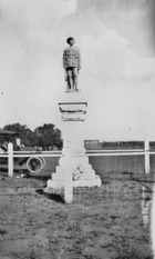

The Kaimkillenbun war memorial was first shown to the public on November 13, 1920. It was unveiled by William Vowles, a local politician. The statue of a "digger" (an Australian soldier) was made by R C Ziegler, a stonemason from Toowoomba.
The memorial was first placed near the railway station. Later, it was damaged in a car accident. A new one, made from the original plans, was placed in a park behind The Bun Pub.
Kaimkillenbun on the Big Screen
In 1983, Kaimkillenbun was a movie set! A film called Chase Through the Night was shot there. A famous actress, Nicole Kidman, starred in the movie. Many local people even got to be extras in the film.
How Many People Live Here?
The number of people living in Kaimkillenbun has changed over the years.
- In 2011, about 566 people lived in the area.
- In 2016, the population was 293 people.
- In 2021, the population was 248 people.
What Kaimkillenbun Does
Kaimkillenbun is a rural area, meaning it's mostly about farming and country life. Many homesteads (large farms or properties) are located here.

Schools in Kaimkillenbun Today

Kaimkillenbun State School is a government primary school. It teaches students from Prep (the first year of school) to Year 6. It is located at 2-14 Messenger Street. In 2018, the school had 17 students.
There are no high schools directly in Kaimkillenbun. Students usually go to secondary schools in nearby towns. These include Bell State School (up to Year 10) in Bell, Quinalow State School (up to Year 10) in Quinalow, or Dalby State High School (up to Year 12) in Dalby.
Places to Visit and Services
The historic Bun Pub is a popular spot in town. Kaimkillenbun also has local sporting clubs and groups.
The Kaimkillenbun Rural Fire Brigade is located at 8 Moffat Street. They help keep the community safe from fires.
Famous Faces from Kaimkillenbun
- John Dorge, an Olympic basketball player, was born in Kaimkillenbun.
