Kamenz Rural District facts for kids
Quick facts for kids
Kamenz
|
|
|---|---|
 |
|
| Country | |
| State | Saxony |
| Adm. region | Dresden |
| Capital | Kamenz |
| Area | |
| • Total | 1,340.34 km2 (517.51 sq mi) |
| Population
(2001)
|
|
| • Total | 154,954 |
| • Density | 115.6080/km2 (299.4233/sq mi) |
| Time zone | UTC+1 (CET) |
| • Summer (DST) | UTC+2 (CEST) |
| Vehicle registration | KM |
| Website | http://www.lra-kamenz.de |
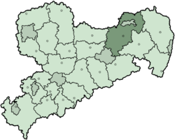
Kamenz (Sorbian languages: Kamjenc) is a Landkreis (which means a rural district or county) in the northeast part of the Free State of Saxony, Germany. The city of Hoyerswerda is completely surrounded by this district. In July 2008, Hoyerswerda became part of the Kamenz district, instead of being a separate city government.
Contents
History of Kamenz District
This district was created in 1994. It was formed by combining parts of older districts. These included the original Kamenz district, the northern areas of the Dresden-Land district (around Radeberg), and most of the Hoyerswerda district. The town of Hoyerswerda itself remained a separate city at that time.
From 1994 to 1996, the district had a different name: Westlausitz - Dresdner Land. But then, it was renamed Kamenz again.
Partner Districts
Since December 14, 1990, the Kamenz district has been a partner with the district of Alzey-Worms. This partner district is located in Rhineland-Palatinate, another state in Germany. This kind of partnership is often called a "twin town" or "sister city" relationship. It helps different regions learn from each other.
Kamenz District Coat of Arms
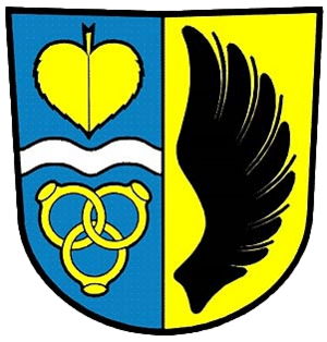
The coat of arms for the Kamenz district has special symbols. These symbols tell us about the area's history and people.
- The colors of the coat of arms are the same as those of Upper Lusatia. This is a historical region that Kamenz is part of.
- The black wing on the right side of the shield is a symbol. It represents the old Lords (or rulers) of Kamenz.
- A linden leaf is shown in the top left part. This leaf stands for the Sorbian people. They are a minority group living in this area.
- Below the linden leaf, there is a wavy line. This line represents three important rivers in the district: the Röder, the Elster, and the Spree.
- At the very bottom, there are three rings. These rings symbolize the joining together of the three older districts that formed the current Kamenz district.
Towns and Municipalities
The Kamenz district is made up of several towns and smaller communities called municipalities. Here are some of them:
Towns in Kamenz
- Bernsdorf
- Elstra
- Großröhrsdorf
- Kamenz
- Königsbrück
- Lauta
- Pulsnitz
- Radeberg
- Wittichenau
Municipalities in Kamenz
- Arnsdorf
- Bretnig-Hauswalde
- Crostwitz
- Elsterheide
- Großnaundorf
- Haselbachtal
- Laußnitz
- Lichtenberg
- Lohsa
- Nebelschütz
- Neukirch
- Oberlichtenau
- Ohorn
- Oßling
- Ottendorf-Okrilla
- Panschwitz-Kuckau
- Ralbitz-Rosenthal
- Räckelwitz
- Schönteichen
- Schwepnitz
- Spreetal
- Steina
- Wachau
- Wiednitz
 | Kyle Baker |
 | Joseph Yoakum |
 | Laura Wheeler Waring |
 | Henry Ossawa Tanner |


