Kaw City, Oklahoma facts for kids
Quick facts for kids
Kaw City, Oklahoma
|
|
|---|---|

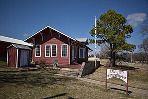
The 1903 Santa Fe Depot, moved before the original townsite was flooded, now part of the Kaw City Museum.
|
|

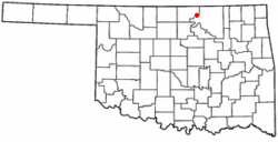
Location of Kaw City, Oklahoma
|
|
| Country | United States |
| State | Oklahoma |
| County | Kay |
| Area | |
| • Total | 6.12 sq mi (15.85 km2) |
| • Land | 3.01 sq mi (7.80 km2) |
| • Water | 3.11 sq mi (8.05 km2) |
| Elevation | 1,175 ft (358 m) |
| Population
(2020)
|
|
| • Total | 325 |
| • Density | 107.94/sq mi (41.68/km2) |
| Time zone | UTC-6 (Central (CST)) |
| • Summer (DST) | UTC-5 (CDT) |
| ZIP code |
74641
|
| Area code(s) | 580 |
| FIPS code | 40-38800 |
| GNIS feature ID | 2410168 |
Kaw City is a small city in eastern Kay County, Oklahoma, in the United States. In 2020, about 325 people lived there. The city got its name from the Kanza Indians, who were often called the Kaw by local people.
History of Kaw City
The first Kaw City was started in 1902. This was before Oklahoma became a state. It was a farming town located in a fertile bend of the Arkansas River. Kaw City was right across the river from the Kaw Indian reservation. By 1907, when Oklahoma became a state, 486 people lived there.
In 1919, Kaw City became a busy oil town. This happened when oil, sometimes called 'black gold,' was found nearby in Kay County and the Osage Nation reservation. The town's population grew a lot, from 627 people in 1920 to 1,001 in 1930. Kaw City even had a popular four-story hotel. This hotel held a very rare art collection belonging to Laura A. Clubb, who was married to a local rancher. She later gave her art collection to the Philbrook Art Museum.
Sadly, a big flood hit most of the town in 1923. Then, the Great Depression caused more problems for the town.
In the late 1960s, the Army Corps of Engineers built Kaw Dam on the Arkansas River. This dam was just south of the original Kaw City. Because of the dam, the old town went underwater permanently in 1976 when the dam's gates closed. This turned that part of the Arkansas River into Kaw Lake.
A banker and oilman named Dave Morgan helped the town. He loaned Kaw City the money it needed to move about two miles west. The new town was built on a hill near the old town's cemetery. The first house in the new location was built in the summer of 1969. Mail started being delivered there on June 26, 1972. Many buildings from the old Kaw City were moved to the new, higher ground. This included the old Santa Fe Railroad Depot, which is now the Kaw City Museum. The Santa Fe Railroad Depot is a special building. It is listed on the National Register of Historic Places. It is one of only two listed buildings in Oklahoma that were moved from their original spots to make way for a lake. When the water in Kaw Lake is very low, you can sometimes still see the foundations of the old buildings just above the water.
The Kaw City Cemetery was also moved. All the headstones and most of the caskets were moved to a special section in Ponca City's IOOF cemetery. The Kaw Indian cemetery, which was across the Arkansas River, was moved to Newkirk, Oklahoma.
Geography
Kaw City is located on a piece of land that sticks out into Kaw Lake. This lake was formed by damming the Arkansas River. Washunga is to the north, across the lake. Oklahoma State Highway 11 goes through Kaw City.
The city covers about 6.12 square miles (15.85 square kilometers). About 3.01 square miles (7.80 square kilometers) of this is land, and 3.11 square miles (8.05 square kilometers) is water. This means a little more than half of the city's area is water!
Population Changes
| Historical population | |||
|---|---|---|---|
| Census | Pop. | %± | |
| 1910 | 595 | — | |
| 1920 | 627 | 5.4% | |
| 1930 | 1,001 | 59.6% | |
| 1940 | 809 | −19.2% | |
| 1950 | 561 | −30.7% | |
| 1960 | 457 | −18.5% | |
| 1970 | 283 | −38.1% | |
| 1980 | 283 | 0.0% | |
| 1990 | 314 | 11.0% | |
| 2000 | 372 | 18.5% | |
| 2010 | 375 | 0.8% | |
| 2020 | 325 | −13.3% | |
| U.S. Decennial Census | |||
In 2000, there were 372 people living in Kaw City. There were 159 households and 109 families. The average household had 2.34 people, and the average family had 2.82 people.
The population was spread out by age. About 26.9% of the people were under 18 years old. About 18.5% were 65 years old or older. The average age was 39 years.
Arts and Culture
The Kaw City Museum is located in the town’s old train depot from 1902. It has many exhibits that show the history of the area.
The Kanza Museum and Education Resource Center displays tribal art and old items from the Kaw Nation.
You can also see outdoor art in Kaw City. The Consultant of the SouthWind Statue is on the north side of Highway 11, near the Kaw Tribal headquarters. The Deer Jumping Fence Sculpture is on the south side of Highway 11, close to City Hall.
The First United Methodist Church in Kaw City is known for its beautiful stained glass windows, oil paintings, and a special Kilgren Pipe Organ.
Education
Students in Kaw City go to schools in the Shidler Public Schools district.
See also
 In Spanish: Kaw City (Oklahoma) para niños
 | Emma Amos |
 | Edward Mitchell Bannister |
 | Larry D. Alexander |
 | Ernie Barnes |

