Keele River facts for kids
Quick facts for kids Keele River |
|
|---|---|

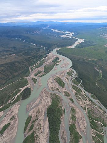
Braided channel above Summit Creek
|
|
| Country | Canada |
| Territory | Northwest Territories |
| Physical characteristics | |
| Main source | Selwyn Mountains 1,401 m (4,596 ft) |
| River mouth | Mackenzie River 121 m (397 ft) 64°25′N 124°48′W / 64.417°N 124.800°W |
| Length | 410 km (250 mi) |
| Basin features | |
| Progression | Southwest-northeast |
| Basin size | 19,000 km2 (7,300 sq mi) |
| Tributaries |
|
The Keele River is a long river in Canada's Northwest Territories. It flows into the mighty Mackenzie River. The Keele River is about 410 kilometers (255 miles) long. It winds through a wild, rugged area of the Mackenzie Mountains. Not many people live in this beautiful region.
Contents
Journey of the Keele River
The Keele River starts in a small, unnamed lake. This lake is near the border of the Northwest Territories and the Yukon. It's about 25 kilometers (16 miles) south of Macmillan Pass. The river first flows northwest through a treeless, high-up area. This area is called the Mackenzie Mountain Barrens. Along the way, it meets the Tsichu and Intga Rivers.
Flowing Through the Mountains
The river then drops from the high plateau. It begins a long journey down to the Mackenzie River. It gradually tumbles into the amazing Backbone Ranges. These are part of the Mackenzie Mountains. About 100 kilometers (62 miles) from its start, the Natla River joins the Keele. This nearly doubles the Keele's water flow and size.
From where the Natla River joins, the Keele turns north. It snakes along for 85 kilometers (53 miles). Then it meets the Twitya River, its biggest tributary. The Twitya River flows in from the west. Just after this, the Keele turns east. It flows around the Tigonankweine Range. This is because of the huge Mount Eduni Massif.
Reaching the Mackenzie River
The Keele River keeps flowing east. It passes between the stunning Canyon and Redstone Ranges. The Toochingkla River also joins it from the south. After leaving the mountains, the river becomes slower. It spreads out into many smaller channels, which is called "braided." Middle Creek flows into it from the south. Finally, the Keele River joins the Mackenzie River. This is about 13 kilometers (8 miles) downstream from the Redstone River. It's also about 50 kilometers (31 miles) south of Tulita.
History of the Keele River
People have lived near the Keele River for at least 11,000 years. The local Dene people have a special name for the Keele River. They call it Begádeé, which means "Winding River."
An Ancient Trade Route
The river was an important trade route for some Mountain Dene tribes. In the summer, they would hunt and trade near the Yukon/NWT border. Then, they would build large boats from moose skin. They would fill these boats with furs and other goods. They paddled down the Keele River to their winter camps. These camps were along the Mackenzie River Valley.
There, they traded their furs and goods. They got supplies to help them survive the long winter. They traded with the Lowland Dene People. Later, they also traded with the Hudson Bay trading post. This post was built at Fort Norman in the 1800s. In the spring, they would walk back to the mountains.
Changes Over Time
In 1921, King George V signed Treaty 11. This treaty was about land in the Yukon. After this, the Dene visited the Yukon border area less often. As a result, the Keele River was also used less for travel. The Keele River was also once known as the Gravel River.
The river and Keele Peak are named after Joseph Keele. He was part of the Geological Survey of Canada. He explored the area in 1907–08. He traveled down the Keele River from its start to the Mackenzie River.
Fun on the Keele River
The Keele River is becoming famous for wilderness canoeing and rafting. It's like a less busy cousin to the South Nahanni River. Hundreds of people paddle its lower section each summer.
Why It's Great for Paddling
The Keele River is perfect for adventurers. It has amazing mountain views. You can also enjoy great fishing and see lots of wildlife. The river has fun but challenging whitewater rapids. These are rated as class 2+. This means they are exciting but not too hard. Best of all, there are no portages needed. This means you don't have to carry your boat around obstacles.
The river has swift currents and clear, blue glacial water. It's in a wild area, far from any roads. This makes paddling the Keele a thrilling experience.
Planning Your Trip
The Keele River is good for beginner canoeists. But they should go with a guided trip. Intermediate paddlers can try it on their own. Several companies offer guided tours. They also provide gear for trips down the Natla/Keele river system. These trips happen all summer long.
Most trips start from Norman Wells or Fort Simpson. People fly by floatplane and land on the river. They usually land where the Natla and Keele rivers meet. Trips usually last between 10 and 14 days. You can even make it longer by adding the Natla River. But the Natla is a class 3+ river. This means it's only for expert paddlers.
The upper part of the Keele River is also navigable. It's rated class 2-3. But it's harder to get to. There are no lakes for float planes to land on near its source. Paddlers wanting to explore this section often use the Tischu River. The Tischu is a class 3-4 river. They reach it after landing at an airstrip on Mile 222 of the Canol Road.
 | Selma Burke |
 | Pauline Powell Burns |
 | Frederick J. Brown |
 | Robert Blackburn |

