
Tulita facts for kids
Quick facts for kids
Tulita
Tulít’a
|
|
|---|---|
 |
|

Tulita
Location in Northwest Territories

Tulita
Location in Canada
|
|
| Country | Canada |
| Territory | Northwest Territories |
| Region | Sahtu |
| Settlement area | Sahtu |
| Constituency | Sahtu |
| Hamlet | 1 April 1984 |
| Area
(2021)
|
|
| • Land | 52.28 km2 (20.19 sq mi) |
| Elevation | 101 m (331 ft) |
| Population
(2021)
|
|
| • Total | 396 |
| • Density | 7.6/km2 (20/sq mi) |
| Time zone | UTC−07:00 (MST) |
| • Summer (DST) | UTC−06:00 (MDT) |
| Canadian Postal code |
X0E 0K0
|
| Area code(s) | 867 |
| Telephone exchange | 588 |
| - Living cost | 177.5 |
| - Food price index | 165.8 |
| Sources: Department of Municipal and Community Affairs, Prince of Wales Northern Heritage Centre, Tulita profile at the Legislative Assembly Canada Flight Supplement 2013 figure based on Edmonton = 100 2015 figure based on Yellowknife = 100 |
|
Tulita is a small community, called a hamlet, in the Northwest Territories of Canada. Its name means "where the rivers or waters meet" in the Slavey language. Before January 1, 1996, it was known as Fort Norman.
Tulita is located where the Great Bear River and the Mackenzie River join together. The Great Bear River starts at Great Bear Lake, which is close to Deline. The area around Tulita has many trees and is south of the tree line. The ground beneath is mostly permafrost, which means it's frozen all year round. Mountains surround Tulita, and they are home to animals like Dall sheep and mountain goats.
Contents
Discovering Tulita's Past
Tulita started as a trading post in the 1800s. This post was set up by the Hudson's Bay Company. It was first called Fort Norman. Over time, the trading post moved to different spots. It was on the Mackenzie River, on islands, and even near Great Bear Lake.
In 1869, Fort Norman moved to its current location. This is where the Mackenzie and Bear Rivers meet. The community became more important in the 1920s. This was when oil was discovered nearby at a place called Norman Wells. Tulita also became a permanent home for the Sahtu Dene people. Their traditional lands were where the original trading post was built. In 1996, the name Fort Norman was officially changed to Tulita.
People Living in Tulita
Tulita is a small community with a close-knit population. In the 2021 Canadian census, 396 people lived there. Most of the people in Tulita are Indigenous. They are mainly First Nations and Métis people. The main languages spoken are North Slavey and English. Some people also speak Dene.
| How Tulita's Population Has Changed | ||
|---|---|---|
| Year | Pop. | ±% |
| 1976 | 232 | — |
| 1981 | 286 | +23.3% |
| 1986 | 332 | +16.1% |
| 1991 | 375 | +13.0% |
| 1996 | 450 | +20.0% |
| 2001 | 473 | +5.1% |
| 2006 | 505 | +6.8% |
| 2011 | 478 | −5.3% |
| 2016 | 477 | −0.2% |
| 2021 | 396 | −17.0% |
| Source: Statistics Canada |
||
Getting Around and Visiting Tulita

You can reach Tulita by air all year round. The community has its own airport, Tulita Airport. Most flights come from Norman Wells, which is a larger nearby town. In the middle to late winter, a special winter road connects Tulita to Wrigley. From Wrigley, you can get to the main Mackenzie Highway.
During the summer, you can travel to Tulita by barge or canoe. These boats travel along the Mackenzie River from Hay River. The government of the Northwest Territories is looking for money to extend the Mackenzie Highway. This would connect Wrigley, Tulita, and Tsiigehtchic.
Tulita has some useful places for residents and visitors. There is a hotel, a Northern Store for groceries, and a Royal Canadian Mounted Police office. There is also a nursing station for health care. Students attend Chief Albert Wright School, which teaches grades K-12. The hamlet also has a library, an arena, a recreation hall, and a fitness centre.
First Nations in Tulita
The Dene First Nations people of Tulita have their own government. It is called the Tulita Dene First Nation. This group is part of the Sahtu Dene Council. Other members include the Behdzi Ahda' First Nation, Délı̨nę First Nation, and Fort Good Hope First Nation.
The people from Tulita are part of the Sahtu Agreement. This agreement gives them shared ownership of a large area of land. This land covers 41,437 square kilometers in the Sahtu Region. Under this agreement, the communities in the region are working towards self-government. This means they want to make their own decisions about their lands and people. As of 2019, only Délı̨nę has finished its self-government agreement.
Famous People from Tulita
- Leslie Nielsen, a famous actor, lived here when he was a child. His father was working with the Royal Canadian Mounted Police in Tulita.
Tulita's Weather
Tulita has a subarctic climate. This means it has mild to warm summers. The winters are very cold, with temperatures often well below zero. Most of the snow falls in October and November. Rain mostly happens during the warmer months.
| Climate data for Tulita Airport | |||||||||||||
|---|---|---|---|---|---|---|---|---|---|---|---|---|---|
| Month | Jan | Feb | Mar | Apr | May | Jun | Jul | Aug | Sep | Oct | Nov | Dec | Year |
| Record high humidex | 3.9 | 4.8 | 6.7 | 19.7 | 29.0 | 34.7 | 40.0 | 44.8 | 26.5 | 20.1 | 4.0 | −1.2 | 44.8 |
| Record high °C (°F) | 5.6 (42.1) |
8.3 (46.9) |
15.0 (59.0) |
20.6 (69.1) |
31.7 (89.1) |
34.4 (93.9) |
36.9 (98.4) |
34.6 (94.3) |
28.5 (83.3) |
22.8 (73.0) |
8.3 (46.9) |
3.0 (37.4) |
36.9 (98.4) |
| Mean daily maximum °C (°F) | −21.7 (−7.1) |
−19.1 (−2.4) |
−11.5 (11.3) |
0.7 (33.3) |
12.4 (54.3) |
20.9 (69.6) |
22.7 (72.9) |
19.2 (66.6) |
10.3 (50.5) |
−2.2 (28.0) |
−14.5 (5.9) |
−18.6 (−1.5) |
−0.1 (31.8) |
| Daily mean °C (°F) | −25.2 (−13.4) |
−23.4 (−10.1) |
−17.3 (0.9) |
−5.3 (22.5) |
6.6 (43.9) |
14.9 (58.8) |
17.1 (62.8) |
14.1 (57.4) |
6.2 (43.2) |
−5.0 (23.0) |
−17.8 (0.0) |
−22.3 (−8.1) |
−4.8 (23.4) |
| Mean daily minimum °C (°F) | −28.7 (−19.7) |
−27.6 (−17.7) |
−23.0 (−9.4) |
−11.3 (11.7) |
0.7 (33.3) |
8.9 (48.0) |
11.5 (52.7) |
9.0 (48.2) |
2.1 (35.8) |
−7.8 (18.0) |
−20.7 (−5.3) |
−25.9 (−14.6) |
−9.4 (15.1) |
| Record low °C (°F) | −53.9 (−65.0) |
−54.4 (−65.9) |
−50.0 (−58.0) |
−40.0 (−40.0) |
−23.9 (−11.0) |
−5.6 (21.9) |
−3.3 (26.1) |
−7.8 (18.0) |
−15.6 (3.9) |
−32.8 (−27.0) |
−49.0 (−56.2) |
−53.3 (−63.9) |
−54.4 (−65.9) |
| Record low wind chill | −56.5 | −57.1 | −55.6 | −36.3 | −24.0 | −5.9 | 0.0 | 0.0 | −12.3 | −35.4 | −48.3 | −55.2 | −57.1 |
| Average precipitation mm (inches) | 14.8 (0.58) |
11.5 (0.45) |
8.7 (0.34) |
9.1 (0.36) |
13.4 (0.53) |
36.0 (1.42) |
44.2 (1.74) |
46.9 (1.85) |
38.9 (1.53) |
32.8 (1.29) |
21.8 (0.86) |
15.0 (0.59) |
293.0 (11.54) |
| Average rainfall mm (inches) | 0.0 (0.0) |
0.0 (0.0) |
0.0 (0.0) |
0.7 (0.03) |
9.8 (0.39) |
35.9 (1.41) |
44.2 (1.74) |
46.9 (1.85) |
36.5 (1.44) |
2.7 (0.11) |
0.0 (0.0) |
0.0 (0.0) |
176.8 (6.96) |
| Average snowfall cm (inches) | 14.8 (5.8) |
11.5 (4.5) |
8.7 (3.4) |
8.5 (3.3) |
3.7 (1.5) |
0.1 (0.0) |
0.0 (0.0) |
0.0 (0.0) |
2.4 (0.9) |
30.1 (11.9) |
22.2 (8.7) |
15.0 (5.9) |
116.7 (45.9) |
| Average precipitation days (≥ 0.2 mm) | 7.1 | 5.7 | 5.8 | 3.9 | 4.7 | 7.6 | 9.1 | 9.1 | 8.6 | 9.4 | 8.9 | 8.3 | 88.1 |
| Average rainy days (≥ 0.2 mm) | 0.0 | 0.0 | 0.0 | 0.3 | 3.5 | 7.6 | 9.1 | 9.1 | 7.6 | 1.5 | 0.1 | 0.0 | 38.7 |
| Average snowy days (≥ 0.2 cm) | 7.1 | 5.7 | 5.8 | 3.7 | 1.2 | 0.1 | 0.0 | 0.0 | 0.9 | 8.1 | 8.9 | 8.3 | 49.7 |
| Source: Environment Canada Canadian Climate Normals 1981–2010 | |||||||||||||
Images for kids
-
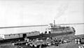
Sternwheeler Distributor and barge at Fort Norman, 1936
-
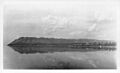
Fort Norman and Bear Rock
-
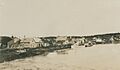
The Imperial Oil Company's expedition to the Fort Norman oil fields, 1921
-
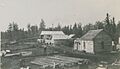
The Imperial Oil Company's expedition to the Fort Norman oil fields, 1921


.jpg)
.jpg)
