
Délı̨nę facts for kids
Quick facts for kids
Délı̨nę
Délįnę
|
|
|---|---|
|
Charter Community
|
|
 |
|

Great Bear Lake, NWT, Canada
|
|

Délı̨nę
Location in Northwest Territories

Délı̨nę
Location in Canada
|
|
| Country | Canada |
| Territory | Northwest Territories |
| Region | Sahtu |
| Settlement area | Sahtu |
| Constituency | Sahtu |
| Charter Community | 1 April 1993 |
| Area | |
| • Land | 79.44 km2 (30.67 sq mi) |
| Elevation | 214 m (702 ft) |
| Population
(2016)
|
|
| • Total | 533 |
| • Density | 6.7/km2 (17/sq mi) |
| Time zone | UTC−07:00 (MST) |
| • Summer (DST) | UTC−06:00 (MDT) |
| Canadian Postal code |
X0E 0G0
|
| Area code(s) | 867 |
| Telephone exchange | 589 |
| Living cost | 167.5 |
| Food price index | 164.5 |
| Website | www.deline.ca |
| Sources: Department of Municipal and Community Affairs, Prince of Wales Northern Heritage Centre, Canada Flight Supplement 2013 figure based on Edmonton = 100 2015 figure based on Yellowknife = 100 |
|
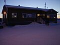
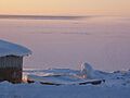
Délı̨nę is a special community in the Northwest Territories, Canada. It's located on the western shore of Great Bear Lake. The community is about 544 kilometers (338 miles) northwest of Yellowknife, the capital city.
The name Délı̨nę means "where the waters flow" in the North Slavey language. This refers to the start of the Great Bear River, also known as Sahtúdé. Délı̨nę is the only settlement right on the shores of Great Bear Lake today. Other old settlements like Fort Confidence and Port Radium are no longer used.
Contents
History of Délı̨nę

People have lived in the Délı̨nę area for a very long time. Early records show that a trading post was set up here in 1799. However, it didn't last many years.
Early Explorers and Hockey's Roots
In 1825, a man named Peter Warren Dease built an outpost for the Hudson's Bay Company (HBC). This was a base for Sir John Franklin's second trip to the Arctic. His expedition lasted from 1825 to 1827. This outpost became known as Fort Franklin.
Sir John Franklin wrote in his diary that his men played games on the ice. These games were very similar to what we now call ice hockey. Because of this, Délı̨nę is proud to say it might be one of the birthplaces of modern hockey!
Trading Posts and Community Growth
The Hudson's Bay Company later returned to the area. They built another post called Fort Norman between 1863 and 1869. This was a short distance from Franklin's original fort. Later, Fort Norman moved to where the Mackenzie and Bear Rivers meet, which is now the community of Tulita.
Fort Franklin became a modern trading post for the HBC later in the 1800s. It was built near one of the best fishing spots for the Dene people. This helped the Dene who lived quite isolated around Great Bear Lake.
Uranium Mining and Its Impact
The area became very important when a mineral called pitchblende was found. This was at the Eldorado Mine, about 250 kilometers (155 miles) away. During World War II, the Canadian Government took over the mine. They started producing uranium for a secret American project to build a nuclear bomb. This project was called the Manhattan Project.
The uranium was moved from Port Radium across Great Bear Lake by barge. Then, it was carried over land along the Bear River. Many Dene men worked on this portage network. At the time, people didn't fully understand the dangers of working with radioactive materials. It is believed that many Dene people were exposed to harmful substances. Residents of Délı̨nę believe this led to serious health problems and early deaths in their community.
Changing Names and Protecting History
On June 1, 1993, the name of Fort Franklin was officially changed to Délı̨nę. This new name, "where the waters flow," honors the headwaters of the Great Bear River, Sahtúdé.
A special place nearby, Saoyú-ʔehdacho, became Canada's largest National Historic Site in 1997. It is managed together by Parks Canada and the Délı̨nę First Nation.
Recent Events
In March 2016, a large tank truck had an accident on the ice road. The truck was carrying about 30,000 liters (7,925 gallons) of heating fuel. It was one of many trucks bringing supplies to Délı̨nę. The accident happened close to the community's fresh water source and a major fishing area. Luckily, the fuel was safely removed from the truck before it could cause a big problem.
Archaeology Discoveries
Sir John Franklin's outpost from 1825–1827 was dug up by archaeologists in 1987. This excavation was done by the Prince of Wales Northern Heritage Centre. They found interesting items like beads, rings, and buttons. These items show how much the Dene people traded with the Europeans back then.
This important historical site is now protected by special rules. In 1996, it was officially named a National Historic Site of Canada.
Community Population
Délı̨nę is a small but strong community. In the 2021 Census, 573 people lived in Délı̨nę. This was a small increase from 533 people in 2016.
Most of the people living in Délı̨nę are Indigenous. In the 2016 Census, there were 495 Indigenous people. This included 485 First Nations people, mostly Sahtu Dene who speak the North Slavey language. There were also 10 Métis people.
Climate and Weather
Délı̨nę has a subarctic climate. This means it has mild summers and very cold winters. It doesn't get a lot of rain or snow, but there's a bit more precipitation in the summer months.
| Climate data for Délı̨nę (Déline Airport) Climate ID: 214274; coordinates 65°12′40″N 123°26′10″W / 65.21111°N 123.43611°W; elevation: 214.0 m (702.1 ft); 1981–2010 normals. |
|||||||||||||
|---|---|---|---|---|---|---|---|---|---|---|---|---|---|
| Month | Jan | Feb | Mar | Apr | May | Jun | Jul | Aug | Sep | Oct | Nov | Dec | Year |
| Record high humidex | 2.8 | 0.5 | 3.8 | 16.6 | 22.8 | 29.8 | 33.5 | 31.8 | 22.9 | 20.5 | 2.4 | 0.3 | 33.5 |
| Record high °C (°F) | 2.5 (36.5) |
1.0 (33.8) |
4.0 (39.2) |
16.0 (60.8) |
22.5 (72.5) |
29.3 (84.7) |
31.2 (88.2) |
32.0 (89.6) |
23.5 (74.3) |
20.8 (69.4) |
4.8 (40.6) |
3.3 (37.9) |
32.0 (89.6) |
| Mean daily maximum °C (°F) | −20.9 (−5.6) |
−18.5 (−1.3) |
−13.9 (7.0) |
−1.9 (28.6) |
7.4 (45.3) |
16.8 (62.2) |
19.4 (66.9) |
16.6 (61.9) |
10.2 (50.4) |
−0.8 (30.6) |
−11.5 (11.3) |
−17.6 (0.3) |
−1.2 (29.8) |
| Daily mean °C (°F) | −25.0 (−13.0) |
−23.2 (−9.8) |
−19.5 (−3.1) |
−7.7 (18.1) |
2.5 (36.5) |
10.7 (51.3) |
13.3 (55.9) |
11.2 (52.2) |
5.7 (42.3) |
−3.9 (25.0) |
−15.4 (4.3) |
−22.0 (−7.6) |
−6.1 (21.0) |
| Mean daily minimum °C (°F) | −28.9 (−20.0) |
−27.8 (−18.0) |
−25.1 (−13.2) |
−13.6 (7.5) |
−2.5 (27.5) |
4.4 (39.9) |
7.2 (45.0) |
5.8 (42.4) |
1.3 (34.3) |
−7.0 (19.4) |
−19.2 (−2.6) |
−26.3 (−15.3) |
−11.0 (12.2) |
| Record low °C (°F) | −49.1 (−56.4) |
−43.3 (−45.9) |
−43.3 (−45.9) |
−35.0 (−31.0) |
−23.3 (−9.9) |
−4.0 (24.8) |
−1.8 (28.8) |
−4.9 (23.2) |
−13.3 (8.1) |
−29.7 (−21.5) |
−37.4 (−35.3) |
−43.0 (−45.4) |
−49.1 (−56.4) |
| Record low wind chill | −57.2 | −54.0 | −55.3 | −40.4 | −27.6 | −6.4 | 0.0 | −3.6 | −16.3 | −34.4 | −46.7 | −54.7 | −57.2 |
| Average precipitation mm (inches) | 10.3 (0.41) |
11.2 (0.44) |
10.3 (0.41) |
10.1 (0.40) |
14.8 (0.58) |
24.3 (0.96) |
40.3 (1.59) |
43.2 (1.70) |
39.5 (1.56) |
31.1 (1.22) |
21.7 (0.85) |
11.9 (0.47) |
268.7 (10.58) |
| Average rainfall mm (inches) | 0.0 (0.0) |
0.0 (0.0) |
0.0 (0.0) |
0.1 (0.00) |
12.2 (0.48) |
24.2 (0.95) |
40.3 (1.59) |
43.2 (1.70) |
37.1 (1.46) |
4.9 (0.19) |
0.4 (0.02) |
0.0 (0.0) |
162.3 (6.39) |
| Average snowfall cm (inches) | 13.0 (5.1) |
16.9 (6.7) |
17.1 (6.7) |
12.3 (4.8) |
3.4 (1.3) |
0.2 (0.1) |
0.0 (0.0) |
0.0 (0.0) |
2.4 (0.9) |
32.2 (12.7) |
35.2 (13.9) |
17.3 (6.8) |
150.0 (59.1) |
| Average precipitation days (≥ 0.2 mm) | 5.4 | 6.8 | 7.5 | 3.9 | 6.1 | 8.0 | 10.4 | 12.3 | 12.4 | 12.4 | 10.1 | 7.2 | 102.4 |
| Average rainy days (≥ 0.2 mm) | 0.0 | 0.0 | 0.0 | 0.2 | 4.5 | 8.0 | 10.4 | 12.3 | 11.8 | 2.4 | 0.1 | 0.0 | 49.7 |
| Average snowy days (≥ 0.2 cm) | 6.7 | 7.5 | 9.4 | 4.2 | 1.7 | 0.1 | 0.0 | 0.0 | 0.9 | 10.5 | 11.4 | 8.9 | 61.4 |
| Average relative humidity (%) | 74.9 | 76.1 | 76.7 | 75.0 | 63.0 | 54.5 | 58.2 | 62.1 | 65.7 | 82.6 | 82.5 | 76.1 | 70.6 |
| Source: Environment and Climate Change Canada | |||||||||||||
Images for kids
-
Déline Airport
-
A view of Délı̨nę


