
Kelshall facts for kids
Quick facts for kids Kelshall |
|
|---|---|
 St Faith's church, Kelshall |
|

Kelshall
|
|
| Population | 163 (2011 Census) |
| OS grid reference | TL 32925 36376 |
| Civil parish |
|
| District |
|
| Shire county | |
| Region | |
| Country | England |
| Sovereign state | United Kingdom |
| Post town | ROYSTON |
| Postcode district | SG8 |
| Dialling code | 01763 |
| Police | Hertfordshire |
| Fire | Hertfordshire |
| Ambulance | East of England |
| EU Parliament | East of England |
Kelshall is a small village in North East Hertfordshire, England. It is located near the town of Royston. The village has a community hall and its local church is called St Faith's. Kelshall is also the name of the civil parish, which is a local government area. A major road runs along one of the village's boundaries.
In the 1880s, the church was described as being "ancient, plain, and good, with a tower". It also contained some old brass plaques and monuments.
Contents
Discovering the Kelshall Hoard
In April 2015, something exciting was announced! A Roman copper-alloy jug was found in a field in Kelshall. It was discovered by a metal detectorist in late 2014.
Unearthing Roman Treasures
After the jug was found, archaeologists started digging. They uncovered a Roman grave. This grave held many other artefacts. These items are believed to be from between 205 and 215 AD.
What Was Found?
The treasures included a silver coin called a denarius from the time of Trajan. There were also three copper-alloy coins from the 2nd century. A lot of Roman glass was found too. This included bottles, glasses, and two special dishes. These dishes were made of many colours and might have come from Roman Alexandria.
Significance of the Finds
In 2017, an expert named Ian Richardson looked at the dishes. He said they were among the five most important finds in recent years. The North Hertfordshire Museum bought these amazing artefacts.
How Kelshall is Governed
Kelshall has three levels of local government. These are the parish, district, and county levels. They include the Kelshall Parish Meeting, North Hertfordshire District Council, and Hertfordshire County Council.
Historical Governance
Kelshall is an ancient parish. It was once part of the hundred of Odsey. From 1835, Kelshall was part of the Royston Poor Law Union. This union helped people who were poor.
Modern Local Government
The Local Government Act 1894 created parish and district councils. Kelshall became part of Ashwell Rural District in December 1894. Even though it was called Ashwell, this council was based in Royston. Kelshall was too small for its own parish council. So, the Kelshall Parish Meeting was set up in December 1894. This meeting took over the local duties of the parish vestry.
Ashwell Rural District was later removed in 1935. It became part of Hitchin Rural District. Then, Hitchin Rural District was also removed in 1974. It became part of North Hertfordshire.
Kelshall's Economy

The 2011 Census tells us about the economy in Kelshall. There were 87 people aged 16–74 who were working. Only 22.3% of the total population worked full-time. There were 24 retired people, making up 19.8% of the population.
Employment in Kelshall
In 2011, 44 of the working people were male. 43 of them were female. The number of people without jobs in Kelshall is low. It is lower than the average for Hertfordshire and the national average. This suggests it might be easier to find a job here than in other places.
Industries in Kelshall
Many different industries are found in Kelshall. For example, 9 people (10.8%) work in manufacturing. In comparison, only 1 person (1.2%) works in Real Estate Activities. Five people (6.0%) work in Financial and Insurance Activities.
Main Industry
The parish is mainly agricultural. The main crops grown are wheat, oats, and root vegetables. Only a small part of the land is used for grazing animals.
Travel and Transport
Kelshall has a local bus service. This service connects the village to important nearby towns. You can travel to Royston, Hitchin, and Letchworth.
Road Connections
The village is about 2 miles south of the Icknield Way. Roads connect Kelshall to this ancient route. These roads join in the village and then go to Therfield. They also lead to Ermine Street at Buckland. There is also a road that goes directly to Buckland. The main part of the village is actually located along this road.
Population Changes

The average age of people in Kelshall is older than the average age in Hertfordshire. The population of Kelshall as a whole is also older than the national average.
Population Trends Over Time
The graph shows how the population has changed. In 1801, there were 179 people. This number grew to 326 people in 1851. This was the highest population during that period. After 1851, the population slowly went down. The lowest it reached was 122 people in 1961.
Recent Population Figures
According to the 2001 census, the population was 151. Out of these, 79 people were married for the first time. 43 people were single and had never been married. Nine people had remarried. The 2011 census showed a population of 163.
Religion in Kelshall
The graphs below show religious identities in Kelshall. In 2001, there were 124 Christians. This group made up 82% of the population. By 2011, the number of Christians decreased to 119, which was 73% of the population.
Changes in Religious Groups
From 2001 to 2011, the number of Muslims increased from 0 to 2. The number of people who said they had no religion also changed. In 2001, there were 17 non-religious people. This was 11% of the population. This number grew to 28 people in 2011, making up 17% of the population.
-
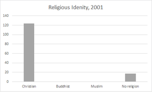
Numbers of people belonging to various religions, 2001
-
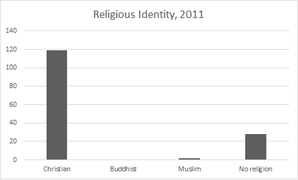
Numbers of people belonging to various religions, 2011


St. Faith's Church
St. Faith's Church was fully repaired between 1868 and 1870. It is located at the edge of the village. The ceilings inside are painted in a medieval style, which was done recently. The south door of the church is also described as being "contemporary," meaning it's from the same time period as the church's original construction.
Church Surroundings

Several small ponds are found to the east of the church. The way the ground is shaped suggests that there might have once been a moat here.
