Kirkby Moor facts for kids
Quick facts for kids Kirkby Moor (Lowick High Common) |
|
|---|---|

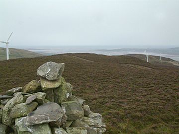
Duddon Sands and wind turbines from the top of Kirkby Moor
|
|
| Highest point | |
| Elevation | 333 m (1,093 ft) |
| Prominence | 230 m (750 ft) |
| Parent peak | Old Man of Coniston |
| Listing | Marilyn |
| Geography | |
| Location | Cumbria, England |
| Parent range | Lake District |
| OS grid | SD259839 |
| Topo map | OS Landranger 96 |
Kirkby Moor is a large, open area of moorland in southern Cumbria, England. It gets its name from the nearby village of Kirkby-in-Furness. This moorland stretches across both sides of the A5092 road. Part of it is inside the Lake District National Park, and part is outside.
The highest part of this area is called Lowick High Common on official maps. However, many people simply call the whole area "Kirkby Moor." Lowick High Common is special because it was the first UK hill to be visited 100 times by amateur radio enthusiasts for a hobby called SOTA.
Exploring Kirkby Moor
The highest point of Kirkby Moor, also known as Lowick High Common, is 333 meters (about 1,092 feet) above sea level. This makes it a great spot for views!
What You Can See
When you visit Kirkby Moor, you'll notice two main human-made features:
- A slate quarry: This is where a company called Burlington Slate Ltd digs for slate, a type of rock used for roofs and floors.
- A wind farm: This farm has 12 large wind turbines. These turbines use the wind to create electricity. RWE Innogy operates this wind farm.
Paths and Access
Kirkby Moor has many paths you can explore.
- There are several public footpaths. These are special paths where people have a legal right to walk.
- The Kirkby Slate Road is another path with public access.
- You'll also find many tracks built for the wind turbines. Even though signs might ask walkers to stay on public paths, it's generally fine to use these newer tracks too.
- Since May 28, 2005, Kirkby Moor has been "access land." This means that under the Countryside and Rights of Way Act 2000, people have the right to walk freely across most of the moor.
The many paths make it easy to find different starting points and routes to explore this heather-covered moor.
What is a Marilyn?
Kirkby Moor is known as a "Marilyn." This is a special term for a hill or mountain in the British Isles that is at least 150 meters (about 492 feet) higher than the land around it. It's a way for hillwalkers to categorize and list different peaks.
 | Delilah Pierce |
 | Gordon Parks |
 | Augusta Savage |
 | Charles Ethan Porter |


