LaBarge Rock facts for kids
Quick facts for kids LaBarge Rock |
|
|---|---|

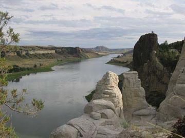
LaBarge Rock (right half of picture, in silhouette), a dark igneous columnar monolith, eroded from white sandstone cliffs along Missouri River, in the Missouri Breaks of Montana.
|
|
| Highest point | |
| Geography | |
| Location | Chouteau County, Montana |
| Geology | |
| Orogeny | Intrusion of igneous rock into sedimentary rock followed by uplift and differential erosion |
| Age of rock | Late Cretaceous - Early Paleogene, 66 mya |
LaBarge Rock is an amazing landform in Chouteau County, Montana. It looks like a giant rock column or pillar, standing 150 feet tall right by the Missouri River. This impressive rock was named after Captain Joseph LaBarge. He was a famous steamboat captain who traveled the Missouri River a long time ago.
LaBarge Rock is not just cool to look at; it's also in a beautiful spot by the river. This has made it a popular subject for artists and photographers for over 200 years. It's a bit hard to get to, located deep in the remote Missouri Breaks area of Montana. The rock itself is made of dark igneous rock. This dark rock stands out against the long, white sandstone cliffs behind it. Because this area is so isolated, LaBarge Rock and the White Cliffs look almost the same today as they did when Lewis and Clark saw them in 1804.
Contents
Why is it called LaBarge Rock?
LaBarge Rock got its name from Captain Joseph LaBarge (1815–1899). He was a very famous and important steamboat captain on the Missouri River. He steered steamboats on the upper Missouri River in Montana during a busy time for river travel.
From 1859 to 1890, steamboats were the main way people and goods traveled. They went from ports in Missouri all the way up to Fort Benton, Montana Territory. This helped people get to and from the mining camps and ranches in central and western Montana. Sometimes, you might see the rock called "La Barge Rock," which is just another way to spell Captain LaBarge's name.
How was LaBarge Rock formed?
LaBarge Rock is made of fine-grained igneous rock, which means it formed from cooled molten rock. This dark rock was created about 66 million years ago, during the Paleogene to late Cretaceous periods.
Deep inside the Earth, hot, liquid rock (called "magma") was forced upwards. It pushed into the layers of sedimentary rock, like white sandstone and shale, that were already there. This process is called an "intrusion".
When the hot magma was forced up, it cracked and moved the surrounding rock. As the molten rock cooled and hardened, it formed different shapes. If it spread horizontally between rock layers, it made sills. If it filled vertical cracks, it formed dikes. If it created a blunt, bullet-shaped mass, it was called a stock.
LaBarge Rock was formed as a "stock." Over millions of years, movements in the Earth's crust brought these hardened igneous rocks closer to the surface. The dark, dense igneous rock is much harder than the softer white sandstone and shale around it. So, as the softer rock wore away from erosion and weathering, the harder igneous rock was left behind. This is how LaBarge Rock became the pillar shape we see today.
In this part of the Missouri Breaks, other similar rock formations exist. These include Dark Butte, Citadel Rock, Grand Natural Wall, Pilot Rock, and Steamboat Rock. These features also formed from igneous intrusions that resisted erosion. The white sandstone and shale cliffs stretch for miles along the river, creating a stunning background.
How tall is LaBarge Rock?
The very top of LaBarge Rock is 2,647 feet above sea level. The rock itself stands about 150 feet tall above the Missouri River.
History of LaBarge Rock
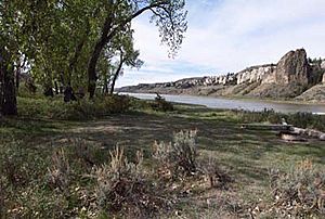
The famous Lewis and Clark explorers camped across from LaBarge Rock on May 31, 1805. They set up their camp at the mouth of Eagle Creek. Today, this area is a popular campground for people who float down the Missouri River. It's known as Eagle Creek campground or sometimes LaBarge campground.
The White Cliffs of the Missouri River
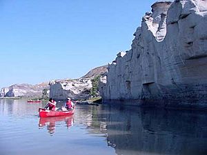
LaBarge Rock is part of a beautiful area called the White Cliffs. This area is also known as White Canyon or White Rocks. It gets its name from the many white sandstone and shale cliffs that line both sides of the Missouri River for long distances. This section of the river is very remote and isolated, within the Missouri Breaks.
The White Cliffs are incredibly striking. They became even more famous after Stephen Ambrose's book about the Lewis and Clark Expedition, "Undaunted Courage", was published. Because of this, more and more people want to float this part of the Missouri River. Many trips start at Coal Banks Landing (river mile 41) and end at Judith Landing (river mile 88).
LaBarge Rock in Art
Karl Bodmer (1809–1893) was a Swiss painter. He traveled with a German explorer named Prince Maximilian from 1832 to 1834. They explored the remote American west along the Missouri River. Karl Bodmer drew and painted images of Native American tribes and important places they saw.
In August 1833, he made drawings and watercolors of LaBarge Rock. These later became part of his famous artworks, Tableau 41 and Tableau 34. Tableau 41, called "View of the Stone Walls on the Upper Missouri," specifically shows LaBarge Rock.
Another artist, Thomas Hart Benton, painted "Lewis and Clark at Eagle Creek" in 1967. This painting shows a view from Eagle Creek, focusing on the amazing White Cliffs. LaBarge Rock would be just outside the left edge of his painting.
Even though LaBarge Rock is hard to reach, its dramatic look makes it a favorite for photographers. Many people who float the river take pictures of it. You can find many different photos of LaBarge Rock by searching online.
Visiting LaBarge Rock
It's not easy to visit LaBarge Rock because it's in a remote part of Montana called the Missouri Breaks. The land away from the river is very rough, with sharply eroded badlands. The roads leading to the river are basic dirt roads and are few and far between.
However, there is a campground across the river from LaBarge Rock. It's called Eagle Creek Campground (or LaBarge Campground) and is used by boaters. You can reach this campground by a dirt road from the north and east bank. But remember, this road crosses private land, so access might be limited.
The most common and best way to see LaBarge Rock and the White Cliffs is to float down the Missouri River. You can do this section in one long day if you use a motorized boat. Or, you can enjoy a more relaxed trip, floating and paddling for several days. This river trip has become very popular recently.
Some people even climb LaBarge Rock! You don't need special rock climbing skills. There are gullies (small valleys) at the river's edge that lead up and around the side of the pillar. On the side away from the river, the rock has eroded enough that you can reportedly reach the top with some effort. This climbing route is described in a book called "A River Calling" by Glenn Frontin.
 | Frances Mary Albrier |
 | Whitney Young |
 | Muhammad Ali |


