
La Grande Béroche facts for kids
Quick facts for kids
La Grande Béroche
|
||
|---|---|---|

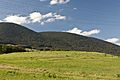
Gorgier Castle above Gorgier village
|
||
|
||

La Grande Béroche
Location in Switzerland

La Grande Béroche
Location in Canton of Neuchâtel
|
||
| Country | Switzerland | |
| Canton | Neuchâtel | |
| Area | ||
| • Total | 42.25 km2 (16.31 sq mi) | |
| Population
(Dec 2020 )
|
||
| • Total | 14,286 | |
| • Density | 338.13/km2 (875.75/sq mi) | |
| Postal code |
2022-24, 2027-28
|
|
| Surrounded by | Autavaux (FR), Boudry, Estavayer-le-Lac (FR), Forel (FR), Noiraigue, Provence (VD), Saint-Aubin-Sauges, Travers | |

La Grande Béroche is a town in Switzerland, found in the Neuchâtel area. It's a fairly new municipality, created on January 1, 2018. This happened when six smaller towns decided to join together: Bevaix, Fresens, Gorgier, Montalchez, Saint-Aubin-Sauges, and Vaumarcus.
Contents
History of La Grande Béroche
The different parts of La Grande Béroche have their own long histories. Here's when each of the original towns was first mentioned in old records:
Bevaix's Past
The town of Bevaix was first written about in the year 998. Back then, it was called in villa Bevacensi. Later, in 1139, its name was recorded as Betuaci.
Fresens Through Time
Fresens appeared in written records for the first time in 1265. It was mentioned as Hiremanz dit de Fressen.
Gorgier's Beginnings
Gorgier's name first showed up in official documents in 1252. It was referred to as de Corgie.
Saint-Aubin-Sauges' History
Saint-Aubin-Sauges was first mentioned in 1176 as Sancti Albini. In 1340, it was also known as villa de Sauges.
Vaumarcus's Story
Vaumarcus was first recorded in 1227, called Valmarcuel. In 1875, it merged with another town called Vernéaz. Until 1966, the combined town was known as Vaumarcus-Vernéaz.
Montalchez's Early Days
Montalchez was first mentioned in 1340. Its name in those old records was villa de Montallichie.
Geography of La Grande Béroche
After the towns merged, La Grande Béroche now covers an area of about 45.25 square kilometers. This is roughly 17.47 square miles. Before 2018, it was part of a larger area called the Boudry district. However, these districts were removed on January 1, 2018.
Population of La Grande Béroche
The new municipality of La Grande Béroche has a total population of about 9,064 people, based on numbers from December 2016.
Historic Population Trends
The chart below shows how the population of the different towns that now make up La Grande Béroche has changed over many years. Each colored bar represents one of the original towns. You can see how the number of people living in each place grew or changed over time.

Important Historical Sites
La Grande Béroche is home to several places that are considered very important to Switzerland's history. These are called "heritage sites of national significance." They include:
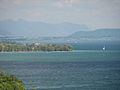
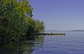
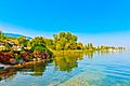
- A prehistoric lake shore settlement at Baie De Bevaix.
- A very old burial and cultural center called Treytel-A Sugiez in Bevaix.
- The historic Gorgier Castle.
- An ancient Gallo-Roman settlement at La Béroche.
- Another prehistoric lake shore settlement in Gorgier, also called La Béroche.
- A neolithic (New Stone Age) settlement at Port Conty / Tivoli in Saint-Aubin-Sauges.
- La Redoute Des Bourguignons, which is a prehistoric site with a Hallstatt burial mound (called a tumulus) in Vaumarcus.
World Heritage Sites: Ancient Lake Dwellings
La Grande Béroche is special because it has three prehistoric sites that are part of the Prehistoric Pile dwellings around the Alps UNESCO World Heritage Site. This means they are recognized as incredibly important to the whole world! These sites are ancient villages built on stilts over water.
- L’Abbaye 2 in Bevaix: This site is from the Bronze Age. It was a village of stilt houses about 180 meters (590 feet) from the lake shore. Scientists have figured out it was built between 1040 and 986 BC. The village was quite large, about 150 by 80 meters (490 by 260 feet), and likely had a bridge connecting it to the land. Around 400 Bronze Age items have been found in the water here.
- Les Argilliez in Gorgier: This site actually has two ancient stilt villages.
- One is a Classical Cortaillod village, with parts dating back to 3841-3817 BC.
- The other is a Late Cortaillod site, from 3531-3528 BC.
Both villages are in a small bay, about 200 meters (656 feet) north of another site. You can still see parts of these villages underwater. Stone axes, antler ax handles, and pottery pieces have been found here.
- Port-Conty in Saint-Aubin-Sauges: This site has two Neolithic (New Stone Age) villages.
- The first is a Late Cortaillod village, with some wood dating to 3574 BC.
- The second is a Late Horgen village, with wood from 3160-3159 BC and 3064-3062 BC.
This site was found in 1860. Later digs showed it was a Neolithic site, not Bronze Age as first thought. In the 1930s, a long trench was dug, revealing three layers of archaeological finds from different parts of the Neolithic period. It seems the site was covered by an artificial mound, about 20 by 10 meters (65 by 32 feet) wide and 70 centimeters (2.3 feet) deep.
-
Baie De Bevaix site
-
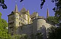
Gorgier Castle
-
La Béroche area
-
Les Argilliez site
-
La Béroche site
-
Port Conty


