
Noiraigue facts for kids
Quick facts for kids
Noiraigue
|
||
|---|---|---|
|
||

Noiraigue
Location in Switzerland

Noiraigue
Location in Canton of Neuchâtel
|
||
| Country | Switzerland | |
| Canton | Neuchâtel | |
| District | Val-de-Travers | |
| Area | ||
| • Total | 6.38 km2 (2.46 sq mi) | |
| Elevation | 729 m (2,392 ft) | |
| Population | ||
| • Total | 506 | |
| • Density | 79.31/km2 (205.4/sq mi) | |
| Postal code |
2103
|
|
| Surrounded by | Boudry, Brot-Dessous, Brot-Plamboz, Gorgier, Travers | |

Noiraigue, also known as Noiraigue-Les Œillons, was once a small town, or municipality, in Switzerland. It was located in the Val-de-Travers area within the canton of Neuchâtel.
Contents
What Happened to Noiraigue?
On January 1, 2009, Noiraigue joined with several other nearby towns. These towns were Boveresse, Buttes, Couvet, Fleurier, Les Bayards, Môtiers, Saint-Sulpice, and Travers. They all merged together to create a larger new municipality called Val-de-Travers. This means Noiraigue no longer exists as a separate town on its own.
Why Do Towns Merge?
Towns sometimes merge for different reasons. It can help them share resources better, like schools or public services. It can also make it easier to manage the area and plan for the future. When towns merge, they often become stronger together.
Location and Geography
Noiraigue was situated in the beautiful Jura Mountains region of Switzerland. It was part of the Val-de-Travers district. This area is known for its lovely landscapes, including valleys and hills. The elevation of Noiraigue was about 729 meters (around 2,392 feet) above sea level.
Neighboring Areas
Before it merged, Noiraigue shared borders with several other municipalities. These included Boudry, Brot-Dessous, Brot-Plamboz, Gorgier, and Travers. Being close to these towns meant there were connections and shared activities among the communities.
Population
In December 2007, just before the merger, Noiraigue had a population of 506 people. This shows it was a small, close-knit community.
Images for kids
-
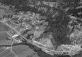
An aerial view of Noiraigue from 1964.
See also
 In Spanish: Noiraigue para niños
