
Estavayer-le-Lac facts for kids
Quick facts for kids
Estavayer-le-Lac
|
||
|---|---|---|

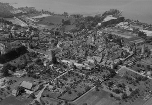
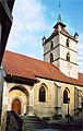
Old City of Estavayer-le-Lac
|
||
|
||

Estavayer-le-Lac
Location in Switzerland

Estavayer-le-Lac
Location in Canton of Fribourg
|
||
| Country | Switzerland | |
| Canton | Fribourg | |
| District | Broye | |
| Area | ||
| • Total | 6.41 km2 (2.47 sq mi) | |
| Elevation | 459 m (1,506 ft) | |
| Highest elevation | 489 m (1,604 ft) | |
| Lowest elevation | 429 m (1,407 ft) | |
| Population
(December 2020)
|
||
| • Total | 6,208 | |
| • Density | 968.5/km2 (2,508.4/sq mi) | |
| Postal code |
1470
|
|
| Surrounded by | Autavaux, Font, Gorgier (NE), Les Montets, Lully, Montbrelloz, Saint-Aubin-Sauges (NE), Sévaz, Vaumarcus (NE) | |

Estavayer-le-Lac is a historic town in Switzerland. It is located in the canton of Fribourg. The town sits right on the southern shore of Lake Neuchâtel. You can find it between the cities of Yverdon and Bern.
Estavayer-le-Lac used to be its own municipality. It was also the main town of the Broye district. In 2012, the nearby municipality of Font joined Estavayer-le-Lac. Later, in 2017, several other towns merged to form a new, larger municipality called Estavayer.
Contents
Exploring Estavayer-le-Lac's Geography


Estavayer-le-Lac covers an area of about 6.4 square kilometers (2.5 square miles). A large part of this land, about 56%, is used for farming. Forests cover about 6% of the area.
Around 33.5% of the land is developed with buildings and roads. A small part, 0.3%, includes rivers or lakes. The remaining 4.7% is land that cannot be used for farming or building. After Font joined in 2012, the total area grew to about 8.9 square kilometers (3.4 square miles).
The town is located on the southern bank of Lake Neuchatel. Its elevation is between 430 and 460 meters (1,410 to 1,510 feet) above sea level. Estavayer-le-Lac is an important center for business and administration in its region.
Understanding the Town's Population

Estavayer-le-Lac has a population of about 5,000 people. In 2008, about 26% of the people living here were from other countries. Over ten years, from 2000 to 2010, the population grew by nearly 20%. Most of this growth was due to people moving into the town.
Most people in Estavayer-le-Lac speak French. About 81% of the residents use French as their main language. German is the second most common language, spoken by nearly 6% of the population. Albanian is the third most common language.
In 2000, about 29% of the population was born in Estavayer-le-Lac. Another 22% were born in the same canton, which is like a state. About 20% were born elsewhere in Switzerland. The remaining 23% were born outside of Switzerland.
Many different age groups live in Estavayer-le-Lac. In 2000, about 13% of the population were children aged 0-9. Teenagers aged 10-19 made up about 15% of the population.
Important Historical Buildings and Sites
Estavayer-le-Lac has many important historical places. These sites are recognized as Swiss heritage sites of national significance. This means they are very important to the country's history and culture.
Some of these special places include:
- The De Rivaz Chapel
- The Sacré-Coeur Chapel
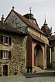
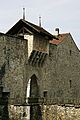
- The impressive Chenaux Castle
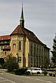
- The Collegiate church of Saint-Laurent
- The Convent of the Dominican nuns
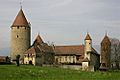
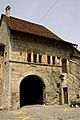
- The old town fortifications
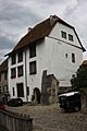
- The House de la Dîme
- The House des Sires d’Estavayer
The entire town of Estavayer-le-Lac is part of the Inventory of Swiss Heritage Sites. This means the whole town is considered a valuable historical area. When Font merged with Estavayer-le-Lac, a Gallo-Roman villa at La Vuardaz was also added to the list of important sites.
-
De Rivaz Chapel
-
Sacré-Coeur Chapel
-
Chenaux Castle
-
Collegiate church of Saint-Laurent
-
Fortifications
-
House de la Dîme
-
House des Sires d’Estavayer


How Estavayer-le-Lac's Economy Works
In 2010, the unemployment rate in Estavayer-le-Lac was about 3.9%. This means that most people who wanted to work had jobs.
The town's economy is divided into three main parts:
- Primary sector: This includes jobs related to farming and natural resources. In 2008, about 28 people worked in this area.
- Secondary sector: This involves manufacturing and construction. About 1,343 people worked in this sector.
- Tertiary sector: This covers services, like shops, hotels, and healthcare. About 1,537 people were employed in this sector.
Many people who live in Estavayer-le-Lac also work there. In 2000, about 1,495 workers came into the town for their jobs. About 812 residents traveled outside the town for work. This shows that Estavayer-le-Lac is a place where many people come to work. Most people, about 58%, used a private car to get to work. About 6% used public transportation.
Religion in Estavayer-le-Lac

According to the 2000 census, most people in Estavayer-le-Lac are Roman Catholic. About 64% of the population belonged to the Roman Catholic Church. About 12% belonged to the Swiss Reformed Church.
Other religions are also present in the town. These include members of Orthodox churches, Christian Catholic Church, and other Christian groups. There were also people who were Jewish, Islamic, Buddhist, and Hindu. About 6.7% of the population did not belong to any church or religion.
Education and Schools
Education is very important in Estavayer-le-Lac. About 30% of the population has completed upper secondary education. This is education after middle school. About 10% have completed even higher education, like at a university.
The school system in the Canton of Fribourg works like this:
- Kindergarten: One year of non-required kindergarten.
- Primary School: Six years of primary school.
- Lower Secondary School: Three years of required secondary school. Students are grouped by their abilities.
- Upper Secondary School: After lower secondary, students can choose to attend a three or four-year optional upper secondary school. This can be a gymnasium (which prepares students for university) or a vocational program.
- Tertiary School: After upper secondary, students can go to a tertiary school or start an apprenticeship.
During the 2010-2011 school year, there were 1,276 students in Estavayer-le-Lac. Many students from other towns also came to study here. At the same time, some residents of Estavayer-le-Lac went to schools outside the town.
Famous People from Estavayer-le-Lac
Estavayer-le-Lac has been home to several notable individuals:
- Franz Wilhelm (1884–1968): A Swiss fencer who competed in the 1920 Summer Olympics.
- Léon Savary (1895–1968): A Swiss journalist and author. He is buried in Estavayer-le-Lac.
- Jan Balet (1913–2009): A German-American painter, graphic artist, and illustrator.
- Gabriel Bullet (1921–2011): A Swiss religious leader in the Roman Catholic Church.
- Jean-Claude Périsset (born 1939): An Archbishop and important diplomat for the Vatican.
- Thérèse Meyer (born 1948): A Swiss politician who served as Mayor of Estavayer-le-Lac in 1991.
See also
 In Spanish: Estavayer-le-Lac para niños
