
Havana Province facts for kids
| Statistics | |
|---|---|
| Capital: | Havana City |
| Area: | 5,731.59km² |
| Inhabitants: | 711,066 |
| Population Density: | 124.06 per km² |
| Map | |

The Havana Province (in Spanish, Provincia de la Habana) was a part of Cuba. It used to be one of Cuba's provinces of Cuba. But on January 1, 2011, it was divided into two brand new provinces: Artemisa Province and Mayabeque Province.
The main city of Havana is actually its own separate province. It is completely surrounded by what used to be Havana Province. In 2002, about 711,066 people lived in the old Havana Province. The biggest city there was Artemisa, with around 75,000 people in 2003. The second largest city was Güines, with about 70,000 people.
Contents
Where Was Havana Province?
Havana Province shared its borders with the city of Havana. It also bordered the provinces of Pinar del Rio and Matanzas. The province had coastlines both in the south and the north. It was home to many towns and a few small cities. Some of these cities were among the 20 to 40 largest on the island of Cuba.
Southern Coast Features
The southern coast of the former province had many swamps. It also featured large areas of wetlands. These are places where the land is often covered with water.
What Did People Do There?
Most of the farms in Havana Province raised cattle. They also grew a lot of food. The main food crops were potatos and different kinds of fruit.
Farming and Industry
Unlike many other parts of Cuba, sugar and tobacco were not the main crops here. They played only a small part in the province's economy. Havana Province also had a lot of industrialization. This means there were many factories and plants. There were many electricity plants and sugar mills in the area.
Images for kids
-
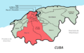
The actual municipalities of the Havana Province. The red colored municipalities (which acts as boroughs) are the original City of Havana while the rest in green are municipalities that combines to be part of the Metropolitan Havana and Province.
-
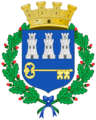
The coat of arms of Havana Province.


See also
 In Spanish: Provincia de La Habana para niños
