Lake Livingston facts for kids
Quick facts for kids Lake Livingston |
|
|---|---|
 |
|
| Location | Polk, San Jacinto, Trinity and Walker Counties, Texas |
| Coordinates | 30°44′N 95°09′W / 30.74°N 95.15°W |
| Type | reservoir |
| Primary inflows | Trinity River |
| Primary outflows | Trinity River |
| Catchment area | 16,616 sq mi (43,040 km2) |
| Basin countries | United States |
| Max. length | 31 mi (50 km) |
| Max. width | 9 mi (14 km) |
| Surface area | 336 km2 (130 sq mi) |
| Average depth | 23 ft (7.0 m) |
| Max. depth | 90 ft (27 m) |
| Water volume | 1,750,000 acre⋅ft (2.16 km3) |
| Shore length1 | over 450 mi (720 km) |
| Surface elevation | 131 ft (40 m) |
| Islands | Alligator Island Pine Island |
| Settlements | Trinity Onalaska Point Blank Riverside Sebastopol |
| 1 Shore length is not a well-defined measure. | |
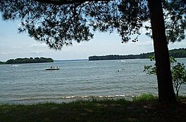
Lake Livingston is a large reservoir (an artificial lake) located in the East Texas Piney Woods region. It was built and is managed by the Trinity River Authority (TRA) of Texas. The lake provides water for the city of Houston.
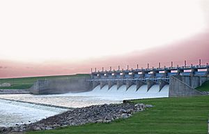
Lake Livingston is the second-largest lake located completely within the state of Texas. Only the Sam Rayburn Reservoir is bigger. The Livingston Dam was built across the Trinity River. It is about 7 miles (11 km) southwest of the city of Livingston. The dam is 2.5 miles (4 km) long and has an average depth of 55 feet (17 m).
Contents
Building Lake Livingston
The money to build Lake Livingston came from selling special bonds. These bonds were paid back by selling water from the lake. Construction of the dam started in 1966 and finished in 1969. The cost to build this large earthen dam was about US$84 million.
How the Lake is Used
The water from Lake Livingston is used for many important things. It supplies water for industries, cities, and farms in the lower Trinity River Basin. It also provides water for the large Houston and Galveston areas. The lake is very important because these areas are growing quickly.
Many fun places for recreation are found along the lake's shoreline. These include marinas, camping spots, and hotels. The City of Houston owns two-thirds of the water rights to the lake. The other one-third is controlled by the TRA.
About the Lake and Dam
The dam is an earthfill dam with a concrete spillway. It was designed to handle a lot of water. The spillway's top is 99 feet (30 m) above sea level. The bottom of the dam's earthen part is about 310 feet (94 m) wide. The spillway can let out three times the largest amount of water ever recorded in the river at this spot.
Lake Livingston covers an area of 83,000 acres (360 km²). It holds 1,750,000 acre-feet (2.16 km3) of water when it is at its normal level. The normal water level is 131 feet (40 m) above sea level. The lake's average depth is 23 feet (7 m), and its deepest point is 90 feet (27 m). Lake Livingston has more than 450 miles (700 km) of shoreline. It stretches into San Jacinto, Polk, Walker, and Trinity Counties.
Managing Water Flow
Lake Livingston was not built to control floods or store extra floodwater. This means that all the water that flows into the lake, whether from rain or the river, must also flow out. The water flow through the dam is controlled by 12 large tainter gates. These gates are part of a concrete and steel spillway that is about 55 feet deep. When the river flow increases, the dam's gates open to let more water out. When the river flow decreases, less water is released.
Major Storms and Repairs
Hurricane Rita's Impact
On September 23, 2005, Hurricane Rita brought strong winds and heavy rain. This caused waves up to 4 feet (1 m) high to hit the Lake Livingston dam. As a result, about 11,000 feet (3.4 km) of large protective stones, called riprap, were pulled off the dam's upstream side.
To fix the damage, the TRA lowered the lake's water level by 4 feet. This helped prevent more erosion of the dam's exposed earthen part. The Federal Emergency Management Agency (FEMA) and the City of Houston paid the $9.6 million repair bill. The repair work involved moving a lot of rock. Over 72,000 tons of large rocks and almost 16,000 tons of smaller bedding rock were brought in by trucks. The rocks came from a quarry near Corsicana. The repairs were mostly finished by April 28, 2006. However, because of a severe drought, the lake's normal water level was not reached again until November 2006.
Hurricane Harvey's Impact
During Hurricane Harvey in 2017, Lake Livingston reached a very high level. It rose to 133.52 feet above mean sea level. The dam had to release a large amount of water, about 110,600 cubic feet per second.
 | George Robert Carruthers |
 | Patricia Bath |
 | Jan Ernst Matzeliger |
 | Alexander Miles |


