
Lake Louise, Alaska facts for kids
Quick facts for kids
Lake Louise
Sasnuu’ Bene’
|
|
|---|---|
 |
|

Location in Matanuska-Susitna Borough and the state of Alaska
|
|

Lake Louise, Alaska
Location in Alaska
|
|
| Country | United States |
| State | Alaska |
| Borough | Matanuska-Susitna |
| Area | |
| • Total | 97.72 sq mi (253.09 km2) |
| • Land | 55.74 sq mi (144.37 km2) |
| • Water | 41.98 sq mi (108.72 km2) |
| Elevation | 2,448 ft (746 m) |
| Population
(2020)
|
|
| • Total | 15 |
| • Density | 0.27/sq mi (0.10/km2) |
| Time zone | UTC-9 (Alaska (AKST)) |
| • Summer (DST) | UTC-8 (AKDT) |
| Area code(s) | 907 |
| FIPS code | 02-42805 |
| GNIS feature ID | 1865556 |
Lake Louise is a small community in Alaska, United States. Its name in the Ahtna language is Sasnuu’ Bene’. It's called a 'census-designated place' (CDP) because it's a special area defined for gathering population data. Even though it's a bit isolated and near Glennallen, Lake Louise is part of the larger Anchorage metropolitan area. In 2020, only 15 people lived there. The population has gotten smaller over the years.
Long ago, the lake was called Shosubenich. This name means "great flat water with many islands". Later, it was named "Lake Adah" after a friend of Lieutenant Castner. Finally, Captain Edwin Glenn changed the name to "Lake Louise" to honor his wife.
Towards the end of World War II, the U.S. Army built a recreation area at the lake. They also built the first road into the area, called Lake Louise Road. This road runs about 20 miles (32 km) from the Glenn Highway to the lake. You can still see some old cabins at the "Army Point" campground. One of these cabins was used by General Dwight D. Eisenhower for four days before he became president. The lake is also home to the Lake Louise State Recreation Area.
Contents
Exploring Lake Louise's Geography
Lake Louise is located on the eastern edge of the Matanuska-Susitna Borough. It sits among four large mountain ranges: the Wrangell, Talkeetna, Chugach, and Alaska ranges.
The Lake Louise area covers about 97.7 square miles (253 square kilometers). A large part of this area, about 42.96%, is water. The southern end of the lake has many small islands, and some homes are built on them. There are also private resorts, marinas, and a state recreation area with places to camp and launch boats.
Understanding Lake Louise's Climate
A weather station called Lake Susitna is about 15 miles (24.1 km) north of Lake Louise. It helps us understand the weather patterns in this cold region.
| Climate data for Lake Susitna, 1991–2020 normals, 1990–2003 extremes: 2375ft (724m) | |||||||||||||
|---|---|---|---|---|---|---|---|---|---|---|---|---|---|
| Month | Jan | Feb | Mar | Apr | May | Jun | Jul | Aug | Sep | Oct | Nov | Dec | Year |
| Record high °F (°C) | 37 (3) |
42 (6) |
51 (11) |
65 (18) |
76 (24) |
85 (29) |
84 (29) |
87 (31) |
70 (21) |
58 (14) |
44 (7) |
38 (3) |
87 (31) |
| Mean maximum °F (°C) | 29.2 (−1.6) |
35.0 (1.7) |
41.4 (5.2) |
54.4 (12.4) |
68.3 (20.2) |
78.6 (25.9) |
79.0 (26.1) |
72.7 (22.6) |
63.4 (17.4) |
48.5 (9.2) |
33.3 (0.7) |
28.5 (−1.9) |
81.1 (27.3) |
| Mean daily maximum °F (°C) | 4.8 (−15.1) |
16.4 (−8.7) |
27.0 (−2.8) |
42.5 (5.8) |
55.7 (13.2) |
66.2 (19.0) |
68.8 (20.4) |
63.1 (17.3) |
52.8 (11.6) |
35.0 (1.7) |
15.8 (−9.0) |
5.0 (−15.0) |
37.8 (3.2) |
| Daily mean °F (°C) | −5.1 (−20.6) |
3.5 (−15.8) |
10.4 (−12.0) |
27.6 (−2.4) |
43.0 (6.1) |
54.3 (12.4) |
57.7 (14.3) |
52.8 (11.6) |
43.1 (6.2) |
26.6 (−3.0) |
6.0 (−14.4) |
−3.8 (−19.9) |
26.3 (−3.1) |
| Mean daily minimum °F (°C) | −15.0 (−26.1) |
−9.5 (−23.1) |
−6.1 (−21.2) |
12.7 (−10.7) |
30.4 (−0.9) |
42.5 (5.8) |
46.5 (8.1) |
42.4 (5.8) |
33.3 (0.7) |
18.2 (−7.7) |
−3.9 (−19.9) |
−12.7 (−24.8) |
14.9 (−9.5) |
| Mean minimum °F (°C) | −42.2 (−41.2) |
−37.0 (−38.3) |
−32.6 (−35.9) |
−13.2 (−25.1) |
14.9 (−9.5) |
31.4 (−0.3) |
36.8 (2.7) |
29.2 (−1.6) |
17.5 (−8.1) |
−6.4 (−21.3) |
−27.3 (−32.9) |
−38.3 (−39.1) |
−48.1 (−44.5) |
| Record low °F (°C) | −53 (−47) |
−54 (−48) |
−43 (−42) |
−29 (−34) |
8 (−13) |
26 (−3) |
29 (−2) |
21 (−6) |
−2 (−19) |
−25 (−32) |
−50 (−46) |
−53 (−47) |
−54 (−48) |
| Average precipitation inches (mm) | 0.47 (12) |
0.55 (14) |
0.37 (9.4) |
0.16 (4.1) |
0.73 (19) |
1.82 (46) |
2.38 (60) |
1.78 (45) |
1.28 (33) |
0.98 (25) |
0.61 (15) |
0.63 (16) |
11.76 (298.5) |
| Average snowfall inches (cm) | 7.60 (19.3) |
6.70 (17.0) |
4.70 (11.9) |
2.60 (6.6) |
2.60 (6.6) |
0.00 (0.00) |
0.00 (0.00) |
0.00 (0.00) |
2.70 (6.9) |
9.70 (24.6) |
8.50 (21.6) |
9.40 (23.9) |
54.5 (138.4) |
| Source 1: NOAA | |||||||||||||
| Source 2: XMACIS2 (records & monthly max/mins) | |||||||||||||
Population and Community Life
| Historical population | |||
|---|---|---|---|
| Census | Pop. | %± | |
| 2000 | 88 | — | |
| 2010 | 46 | −47.7% | |
| 2020 | 15 | −67.4% | |
| U.S. Decennial Census | |||
Lake Louise was first counted as a census-designated place (CDP) in the year 2000. In 2000, there were 88 people living there. Most of the people were White (about 90%), and about 10% were Native American.
There were 41 households in 2000. About 17% of these households had children under 18. Most households (58.5%) were married couples. The average household had about 2 people. The average family had about 2.6 people.
The people living in Lake Louise in 2000 had different ages. About 17% were under 18. About 47% were between 45 and 64 years old. The average age was 47 years.
Fun Activities at Lake Louise Recreation Area
The Lake Louise State Recreation Area is a great place for outdoor fun. It has a large campground where you can set up tents or RVs. There's also a boat launch, so you can easily get your boat onto the lake. Picnic areas are available for outdoor meals.
A trail leads to a hilltop where the old Army recreation cabins still stand. These cabins are very old and not in good shape, but they show the history of the area.
Visitors to Lake Louise can see many different kinds of wildlife. Bird Island, in the lake, is the only known place where cormorants (a type of water bird) nest in freshwater. In the fall, the Nelchina caribou herd travels through this area, which is an amazing sight. Fishing in the lake is also excellent. You can catch various freshwater fish, including lake trout and burbot.
Images for kids
-
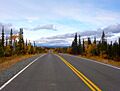
Lake Louise from about 5 miles (8 km) away.

See also
 In Spanish: Lake Louise (Alaska) para niños
