Lake Nipisso facts for kids
Quick facts for kids Lake Nipisso |
|
|---|---|
| Location | Rivière-Nipissis, Sept-Rivières, Quebec |
| Coordinates | 50°51′24″N 65°49′27″W / 50.8567°N 65.8242°W |
| Native name | Lac Nipisso Error {{native name checker}}: parameter value is malformed (help) |
| Primary outflows | Nipisso River |
| Basin countries | Canada |
| Max. length | 25 kilometres (16 mi) |
| Max. width | 4 kilometres (2.5 mi) |
| Surface area | 40 square kilometres (15 sq mi) |
| Surface elevation | 348 metres (1,142 ft) |
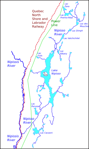
Lake Nipisso (which is called Lac Nipisso in French) is a large lake in a faraway part of Quebec, Canada. It covers about 40 square kilometres (15 sq mi) and is found in the Côte-Nord region.
Contents
Where is Lake Nipisso?
Lake Nipisso is located in a special area called Rivière-Nipissis. This area is part of the Sept-Rivières Regional County Municipality in Quebec's Côte-Nord region.
Location Details
The lake is about 75 kilometres (47 mi) north of a city called Sept-Îles. It's also part of the Duplessis (Côte-Nord) tourist region. Lake Nipisso is quite long, stretching for 25 kilometres (16 mi), and it can be up to 4 kilometres (2.5 mi) wide.
The Nipisso River Connection
Lake Nipisso is actually a wider part of the Nipisso River. This river flows into the north end of the lake from other lakes like Lac Premio-Réal and Lac de Mouches. The river then continues from the south end of Lake Nipisso, flowing southeast. It eventually joins the Nipissis River. The Nipisso River system collects water from a huge area of about 4,196 square kilometres (1,620 sq mi).
Getting to the Lake
There are no roads that lead to Lake Nipisso. This means you can't drive there! The only ways to reach this remote lake are by a special type of plane called a float plane (which can land on water) or by helicopter. A railway line is about 10 kilometres (6.2 mi) west of the lake, and a big power line from the Churchill Falls Generating Station is about 8 kilometres (5.0 mi) to the west.
Lake Nipisso's Environment
The area around Lake Nipisso is in what is called the boreal climate zone. This means it has very cold winters and mild summers.
Climate and Nature
According to Quebec's way of classifying natural areas, Lake Nipisso is in a sub-region known for its high hills. The average temperature in this region is about −3 °C (27 °F) each year. The warmest month is July, with an average temperature of 13 °C (55 °F). The coldest month is January, when the average temperature drops to about −20 °C (−4 °F).
The Land Around the Lake
The region around Lake Nipisso is close to the southern edge of the Canadian Shield. This is an area with rolling hills and rugged mountains that can reach up to 2,100 feet (640 m) high.
Valleys and Glaciers
The Nipissis and Nipisso rivers flow through deep valleys in this hilly land. Lake Nipisso itself sits in what was once a deeper valley, similar to a nearby valley. This valley was filled long ago by glaciers. These glaciers left behind a mix of large rocks, pebbles, silt, and sand. Later, the river reshaped these deposits.
In the southern part of the Lake Nipisso area, you can see signs of strong glacial erosion, but not many glacial deposits. However, further north, there are more glacial materials, especially lots of sand and gravel in the valleys. You can also find many flat sandy areas. Just east of the north end of Lake Nipisso, there are three interesting crescent-shaped ridges made of sand and gravel. These ridges are about 1,000 feet (300 m) long, 40 feet (12 m) wide, and 20 feet (6.1 m) high. They are lined up at a right angle to how the ancient Laurentide Ice Sheet moved. These might be "recessional moraines," which are piles of rock and dirt left behind as a glacier melts and retreats.
Lake Nipisso's Geology
Lake Nipisso is part of a geological area known as the Manitou-Nipisso area. This area is within a larger region called the Grenville Province.
Rocks and Minerals
The main type of rock under Lake Nipisso is called the Manitou Gneiss Complex. This rock is mostly made of quartz-feldspar gneiss and hornblende-biotite gneiss. In 1997, a study looked at a mineral site on the east shore of the lake. They found many of the typical rocks from this area, including felsic gneisses, lots of gabbro, and some smaller granitoid rocks. The site also had special ultramafic dikes (rock formations that cut across other rocks) that contained minerals.
Tributary Lakes
Several smaller lakes drain their water into Lake Nipisso. These include:
- Lac Zara
- Lac Premio-Réal
- Lac des Mouches
- Lac Dimph
- Lac Vatchichilet
- Lac Albany
- Lac Firth
What's in a Name?
The name "Nipisso" comes from the Innu language, which is spoken by Indigenous people in the region. In the past, the lake was also known by other names like Lac Moisi, Lac Moisic, and Lac Moisie.
 | Aurelia Browder |
 | Nannie Helen Burroughs |
 | Michelle Alexander |


