
Lancaster Roman Fort facts for kids
Quick facts for kids Lancaster Roman Fort |
|
|---|---|

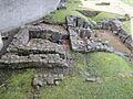
Surviving ruins of the third fort (Wery Wall)
|
|

Location in Lancaster city centre

Location in Lancashire
|
|
| Founded during the reign of | Vespasian / Titus |
| Founded | c. 80 AD |
| Abandoned | 5th century |
| Place in the Roman world | |
| Province | Britannia |
| Nearby water | River Lune |
| Structure | |
| — Stone structure — | |
| Built during the reign of | Trajan |
| Built | c. 102 AD |
| — Wood and earth structure — | |
| Built during the reign of | Vespasian / Titus |
| Built | c. 80 AD |
| Stationed military units | |
| — Cohorts — | |
| ala Augusta, ala Sebosiana, numerus Barcariorum Tigrisiensium | |
| Location | |
| Coordinates | 54°03′05″N 2°48′12″W / 54.05150°N 2.80347°W |
| Town | Lancaster |
| County | Lancashire |
| Country | England |
| Reference | |
| UK-OSNG reference | SN643564 |
| Site notes | |
| Discovery year | 1950 |
| Condition | Earthworks and ruins |
| Controlled by | Scheduled Monument (SAM: CD129) |
The Lancaster Roman Fort, also known as Wery Wall, Galacum or Calunium, was an ancient Roman fort. It stood on Castle Hill in Lancaster, in North West England. The first fort was built around 80 AD. It was part of the Roman province of Britannia, which was the Roman name for Britain.
We don't know the fort's exact Roman name. A Roman milestone found nearby suggested a name starting with "L". However, some historians think the name Galacum might fit Lancaster better.
The name "Lancaster" itself comes from this fort. In the old Domesday Book, it was called Loncastre. "Lon" refers to the River Lune. The word "castre" comes from the Old English word cæster, which means "fort" and was borrowed from the Latin word castrum.
Contents
History of the Fort
The First Fort: Timber and Earth
The very first Roman fort in Lancaster was built around 80 AD. It was made from timber (wood), clay, and turf. Roman coins found in the area suggest activity even earlier, in the 60s AD.
The Romans likely chose Castle Hill because it was a good spot. From there, they could control a crossing point over the River Lune. This first fort had a rectangular shape with rounded corners. Its walls were made of clay and turf, protected by two V-shaped ditches.
The main entrance was on the eastern side. A large settlement, called a vicus, grew up outside the fort along Church Street. The northern wall of the fort was about 187 meters long. The southern wall is thought to be under Lancaster Castle today. Later, the northern defenses were made longer. For a while, a cavalry unit called the ala Augusta might have been stationed here.
The Second Fort: Stone Walls
The fort was used again in the 2nd century. Around 102 AD, it was rebuilt, this time with strong stone walls. These walls were almost 2 meters thick. They were built in front of the older clay-and-turf rampart.
The fort's north gate might have been near Vicarage Lane. A road from this gate led to the river crossing. You can still see some earthworks at Vicarage Field. These are believed to be parts of the fort's northwest corner.
Not much is known about the next two centuries. The fort seems to have been left empty at times. This happened in the mid-2nd century and again around the early 3rd century. An old inscription tells us that a bath-house and a large public building (a basilica) were rebuilt in the mid-3rd century. Around this time, soldiers from the ala Sebosiana and the numerus Barcariorum Tigrisiensium were likely stationed here.
The Third Fort: The Wery Wall

Around 330 AD, the fort was changed a lot. It was rebuilt in a style similar to the Saxon Shore Forts. These forts were built to defend against sea raids. On the northern side, a very thick wall, about 3 meters wide, was built. It had strong, many-sided towers called bastions on the outside. This new wall was built over the remains of the older forts.
The only surviving part of this 4th-century fort is known as the Wery Wall. It was discovered in 1950. It's thought to be the core of a large tower at the northern corner of the wall. This tower probably held a heavy artillery weapon. In the 18th century, a piece of the south wall was found. It wasn't parallel to the north wall, which suggests this fort didn't follow the usual Roman design.
Near the Wery Wall, the remains of a Roman bath-house were found in 1812. Inside, there was a reused stone with an inscription from a Gallic Emperor named Postumus, dating from 262–266 AD. For a long time, people thought this bath-house was built at the same time as the 4th-century fort. However, it's now believed to have been part of a large courtyard building. This building might have been an important home or a guesthouse (a mansio) in the vicus area. It was later taken down to make way for the 4th-century fort.
The fort was expanded a few more times. At its largest, it covered about 9 to 10 acres. Evidence suggests the fort was still active until the Romans left Britain in the early 5th century. This later fort is the only one of its kind known in northwest Britain.
After the Romans
We don't know much about the fort's history right after the Romans left. A Saxon monastery was probably built on the site in the sixth century. This monastery was later replaced by the Benedictine priory in 1094. Roger de Poitou founded this priory, along with Lancaster Castle.
Today, the area is a protected Scheduled Ancient Monument. This means it's an important historical site. The Wery Wall is also a Grade II listed building, which protects its historical importance.
Images for kids
-
Roman bath house on Castle Hill
