Last Chance Range facts for kids
Quick facts for kids Last Chance Range |
|
|---|---|

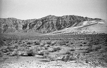
Northern Last Chance Range from Eureka Dunes
|
|
| Highest point | |
| Elevation | 2,645 m (8,678 ft) |
| Geography | |
| Country | United States |
| State | California |
| District | Inyo County |
| Range coordinates | 36°54′31.765″N 117°35′52.264″W / 36.90882361°N 117.59785111°W |
| Topo map | USGS Dry Mountain |
The Last Chance Range is a mountain range found in California, close to the Nevada state line. It's located in the eastern part of Inyo County in the United States. This mountain range stretches for over 30 miles, generally running from north to south.
Most of the Last Chance Range is inside Death Valley National Park. Only a small part near a place called Sulphur Mine in the north is outside the park. These mountains are to the northwest of the Cottonwood Mountains.
Contents
Exploring the Last Chance Range
The Last Chance Range is a cool place to learn about mountains and deserts. It's part of a bigger area known for its unique landscapes.
Where is the Last Chance Range?
This mountain range is in a very dry area. It's part of the Mojave Desert, which is famous for its hot, dry climate. Being mostly inside Death Valley National Park means it's a protected area. This helps keep its natural beauty safe.
What's the Highest Point?
The tallest peak in the Last Chance Range is called Dry Mountain. It reaches an elevation of 8,674 feet (about 2,645 meters) above sea level. This makes it a significant landmark in the southern part of the range.
Nearby Natural Wonders
To the southwest of the Last Chance Range, you can find the Racetrack Playa. This is a famous dry lakebed known for its mysterious moving rocks. These rocks slide across the flat surface, leaving long trails behind them. Scientists are still studying how they move!
 | Jewel Prestage |
 | Ella Baker |
 | Fannie Lou Hamer |


