Leachville, Arkansas facts for kids
Quick facts for kids
Leachville, Arkansas
|
|
|---|---|
 |
|

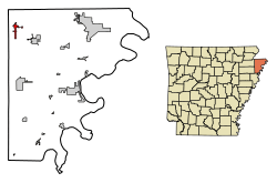
Location in Mississippi County, Arkansas
|
|
| Country | United States |
| State | Arkansas |
| County | Mississippi |
| Founded | 1896 |
| Incorporated | February 2, 1916 |
| Named for | Joshua Gilbert Leach |
| Area | |
| • Total | 4.40 sq mi (11.40 km2) |
| • Land | 4.40 sq mi (11.40 km2) |
| • Water | 0.00 sq mi (0.00 km2) |
| Elevation | 233 ft (71 m) |
| Population
(2020)
|
|
| • Total | 2,039 |
| • Density | 463.09/sq mi (178.81/km2) |
| Time zone | UTC-6 (Central (CST)) |
| • Summer (DST) | UTC-5 (CDT) |
| ZIP code |
72438
|
| Area code(s) | 870 |
| FIPS code | 05-39010 |
| GNIS feature ID | 2404900 |
Leachville is a city located in Mississippi County, Arkansas, in the United States. In 2020, about 2,039 people lived there. Leachville officially became a city in 1916.
Contents
History of Leachville
How Leachville Started
Leachville was founded in 1896 by three land developers: Joshua Gilbert Leach, James Wiseman Honnoll, and Sam McNamee. These developers worked together to create the Leach-McNamee Land Development Company. They helped build up the area.
Railroads and Farming
Trains played a big role in Leachville's early growth.
- In 1899, the Jonesboro, Lake City and Eastern Railroad built a train line to Leachville.
- Later, in 1908, the Blytheville, Leachville and Arkansas Southern Railroad added a second line.
These railroads helped transport goods and people, making the town grow.
Farming was also very important. In the early 1990s, one of Arkansas's largest cotton gins was built in Leachville. A cotton gin is a machine that quickly separates cotton fibers from their seeds, which is a key step in making cotton fabric.
Recent Events: The 2021 Tornado
On December 10, 2021, a very strong tornado hit the northern part of Leachville. This tornado caused a lot of damage to buildings and homes in the area. Many people were affected by the storm.
Geography of Leachville
Where is Leachville Located?
Leachville is found in the Arkansas Delta region. This area is mostly flat land. The city covers about 4.4 square miles (11.4 square kilometers), and all of it is land. Leachville is just south of the border between Arkansas and Missouri, in the northwestern part of Mississippi County.
Nearby Roads and Towns
- Arkansas Highway 77 connects Leachville to Manila, which is about 8 miles (13 km) to the southeast.
- The same highway goes north for about 4 miles (6 km) to the state line at Arkmo. From there, it becomes Missouri Route 108 and heads towards Arbyrd, Missouri.
- Arkansas Highway 119 links Leachville to Arkansas Highway 18 to the south.
Natural Surroundings
Leachville is part of the St. Francis Lowlands ecoregion. An ecoregion is a large area of land or water that contains a geographically distinct group of natural communities and species. This area is mostly flat and used for farming today.
You can still see some unique features from the 1811–12 New Madrid earthquakes, like sand blows (where sand exploded out of the ground) and sunken lands. Many natural waterways in the area have been channelized, meaning they were straightened or deepened. This has changed the homes for water animals and plants that live along rivers (called riparian wildlife).
East of Leachville is the Big Lake National Wildlife Refuge. This refuge helps protect some of the original bottomland hardwood forest that used to cover this ecoregion before it was developed for farming.
Population of Leachville
How Many People Live Here?
The population of Leachville has changed over the years. Here's a quick look at how many people have lived in the city:
- 1930: 1,157 people
- 1940: 1,076 people
- 1950: 1,230 people
- 1960: 1,507 people
- 1970: 1,582 people
- 1980: 1,882 people
- 1990: 1,743 people
- 2000: 1,981 people
- 2010: 1,993 people
- 2020: 2,039 people
In 2020, there were 2,039 people living in Leachville. There were 971 households and 654 families in the city. Most of the people living in Leachville were White (about 81.22%). About 13.05% of the population was Hispanic or Latino.
Education in Leachville
Schools in the Area
Students in Leachville attend schools that are part of the Buffalo Island Central School District. This district runs two main schools:
- Buffalo Island Central High School
- Buffalo Island Central Elementary School
The school's mascot is the mustang.
School District History
The Buffalo Island Central School District was created on July 1, 1984. Before that, Leachville had its own school district called the Leachville School District. On that day, the Leachville School District joined with the Monette School District to form the current Buffalo Island Central School District.
See also
 In Spanish: Leachville para niños
 | Selma Burke |
 | Pauline Powell Burns |
 | Frederick J. Brown |
 | Robert Blackburn |

