
Lebanon, New Jersey facts for kids
Quick facts for kids
Lebanon, New Jersey
|
||
|---|---|---|
|
Borough
|
||

Lebanon Reformed Church
|
||
|
||

Location of Lebanon in Hunterdon County highlighted in red (left). Inset map: Location of Hunterdon County in New Jersey highlighted in orange (right).
|
||

Census Bureau map of Lebanon, New Jersey
|
||

Lebanon, New Jersey
Location in Hunterdon County, New Jersey

Lebanon, New Jersey
Location in New Jersey

Lebanon, New Jersey
Location in the United States
|
||
| Country | ||
| State | ||
| County | Hunterdon | |
| Incorporated | April 20, 1926 | |
| Government | ||
| • Type | Borough | |
| • Body | Borough Council | |
| Area | ||
| • Total | 0.90 sq mi (2.34 km2) | |
| • Land | 0.90 sq mi (2.34 km2) | |
| • Water | 0.00 sq mi (0.00 km2) 0.00% | |
| Area rank | 514th of 565 in state 25th of 26 in county |
|
| Elevation | 246 ft (75 m) | |
| Population
(2020)
|
||
| • Total | 1,665 | |
| • Estimate
(2023)
|
1,670 | |
| • Rank | 505th of 565 in state 20th of 26 in county |
|
| • Density | 1,845.8/sq mi (712.7/km2) | |
| • Density rank | 304th of 565 in state 4th of 26 in county |
|
| Time zone | UTC−05:00 (Eastern (EST)) | |
| • Summer (DST) | UTC−04:00 (Eastern (EDT)) | |
| ZIP Code |
08833
|
|
| Area code(s) | 908 | |
| FIPS code | 3401939630 | |
| GNIS feature ID | 0885275 | |
| Website | ||

Lebanon is a small town called a borough in Hunterdon County, New Jersey. In 2020, about 1,665 people lived here. This was the highest number of people ever recorded in Lebanon! The population grew a lot from 2010 to 2020.
Lebanon officially became a borough on March 26, 1926. This happened after people voted for it on April 20, 1926. Some parts of nearby Clinton Township were added to Lebanon in 1962.
Long ago, in the early 1800s, this area was known by different names. It was called Jacksonville, then Lebanonville, and later Lebanonville Depot. Finally, it became Lebanon. It was an important stop on the Central Railroad of New Jersey.
The center of Lebanon still looks much like it did a hundred years ago. The Dutch Reformed Church is one of the oldest churches in the county. Records show the church started in 1769, but it might have been around since 1747. The Lebanon Historic District was added to important lists in 2009. This means it's a special place with old buildings and history.
On April 5, 2024, Lebanon, along with Oldwick and Tewksbury Township, was near the center of a 4.8 magnitude earthquake. This earthquake was felt across much of the Northeast United States. Earthquakes are rare in this area.
Contents
Geography of Lebanon
Lebanon is a small town that covers about 0.90 square miles (2.34 square kilometers) of land. It has no water area within its borders.
Lebanon is special because it's completely surrounded by Clinton Township. This makes it one of 21 "doughnut towns" in New Jersey. A "doughnut town" is when one town completely wraps around another!
Population and People
| Historical population | |||
|---|---|---|---|
| Census | Pop. | %± | |
| 1930 | 550 | — | |
| 1940 | 638 | 16.0% | |
| 1950 | 752 | 17.9% | |
| 1960 | 880 | 17.0% | |
| 1970 | 885 | 0.6% | |
| 1980 | 820 | −7.3% | |
| 1990 | 1,036 | 26.3% | |
| 2000 | 1,065 | 2.8% | |
| 2010 | 1,358 | 27.5% | |
| 2020 | 1,665 | 22.6% | |
| 2023 (est.) | 1,670 | 23.0% | |
| Population sources: 1930 1940–2000 2000 2010 2020 |
|||
What the 2010 Census Showed
In 2010, there were 1,358 people living in Lebanon. These people lived in 602 homes, and 366 of those were families. The town had about 1,532 people per square mile.
Most people in Lebanon (about 90%) were White. About 5% were Asian, and a smaller number were Black or Native American. About 5% of the population was Hispanic or Latino.
About 28% of homes had kids under 18. Almost half (46.5%) were married couples. About 34% of homes had just one person living there. The average home had 2.26 people.
The average age in Lebanon was 40.2 years old. About 21% of the people were under 18. About 13% were 65 or older.
Lebanon's Historic District
|
Lebanon Historic District
|
|

Italianate style house
|
|
| Location | Main St., Cherry St., Brunswick Ave., Maple St., High St., Lebanon Borough, New Jersey |
|---|---|
| Area | 91 acres (37 ha) |
| Built by | Oscar Apgar; John C. & Harry Stryker |
| Architectural style | Italianate, Bungalow/craftsman |
| NRHP reference No. | 09000652 |
| Significant dates | |
| Added to NRHP | August 26, 2009 |
The Lebanon Historic District is a special area in the town. It was recognized for its important old buildings and how the community grew between 1813 and 1942. This district was added to the National Register of Historic Places on August 26, 2009. It includes 227 buildings that help tell the story of Lebanon's past.
Schools and Education
Students in Lebanon attend different schools depending on their grade level.
Elementary and Middle School
- Kids from pre-kindergarten to sixth grade go to Lebanon Borough School. In the 2018–19 school year, this school had 40 students.
- Students in seventh and eighth grades go to Clinton Township Middle School. This school is in Clinton Township.
High School Education
- For high school, students from ninth to twelfth grade attend North Hunterdon High School. This school is in Annandale.
- Students from several nearby towns also go to North Hunterdon High School.
- There's also a special option for eighth graders in Hunterdon County. They can apply to the Hunterdon County Vocational School District. This school offers training for different jobs and skills.
Emergency Services in Lebanon
Lebanon has several groups that help keep everyone safe.
- Police: The New Jersey State Police provides law enforcement for the borough.
- Fire Department: The Lebanon Volunteer Fire Company helps put out fires.
- Medical and Rescue: The Clinton First Aid & Rescue Squad provides emergency medical help and rescue services.
Getting Around Lebanon
Roads and Highways
_from_the_overpass_for_Hunterdon_County_Route_639_(Cokesbury_Road)_in_Lebanon,_Hunterdon_County,_New_Jersey.jpg)
Lebanon has about 7 miles of roads. Most of these roads are taken care of by the town itself.
- U.S. Route 22 goes right through the middle of Lebanon.
- Interstate 78 runs through the northern part of town. There's an exit (Exit 20) for Lebanon on this highway.
Public Transportation
The Lebanon train station offers train service on NJ Transit's Raritan Valley Line. There is a station building on the south side of the tracks. The train stop has limited service during the week and no service on weekends.
Points of Interest
- Hunterdon County Arboretum
- Round Valley Reservoir
- Cushetunk Mountain
Notable People
People who have lived in or are connected to Lebanon include:
- Alvah A. Clark (1840–1912), who represented New Jersey in the U.S. House of Representatives from 1877 to 1881.
- James N. Pidcock (1836–1899), who also represented New Jersey in the U.S. House of Representatives from 1885 to 1889.
Images for kids
-
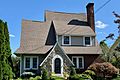
Tudor Revival style house
-
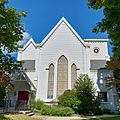
Round Valley United Methodist Church


See also
 In Spanish: Lebanon (Nueva Jersey) para niños
