Lethem, Guyana facts for kids
Quick facts for kids
Lethem
|
|
|---|---|
|
Town and regional capital
|
|

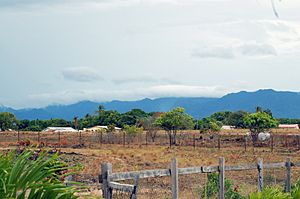
Lethem looking east
|
|
| Country | |
| Region | Upper Takutu-Upper Essequibo |
| Population
(2012)
|
|
| • Total | 1,702 |
| Time zone | UTC-4 |
Lethem is a town in Guyana, a country in South America. It is the main town and capital of the Upper Takutu-Upper Essequibo region.
The town is named after Sir Gordon James Lethem. He was a Governor of British Guiana many years ago. In 2012, about 1,702 people lived in Lethem.
Lethem is a busy place for shopping! You can find stores selling shoes, bicycles, shirts, and many other things. People from Brazil often visit to buy goods to take back to cities like Boa Vista and Manaus.
One of the most exciting events in Lethem is the annual Rodeo. It happens every year during the Easter weekend.
Contents
Life and Work in Lethem
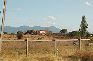
Lethem is located in the Rupununi savannah of Guyana. This area is famous for its vaqueiros, which is the Portuguese word for cowboys, and its many ranches.
You'll find different kinds of trees here, like cashew trees (both for fruit and nuts), mango trees, and Coconut trees. There's even a cashew processing factory in St. Ignatius, a nearby community that is part of Lethem. Other parts of the town include Culvert City and New Culvert City.
When you go shopping in Lethem, you can use different types of money. The local money is the Guyanese Dollar. But many stores also accept Brazilian Reals and even U.S. dollars!
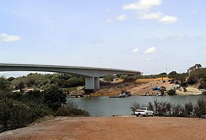
In 2009, a special bridge was built over the Takatu River, just north of Lethem. This bridge connects Guyana and Brazil. It cost about US$5 million and was paid for by Brazil. The bridge helps link northern Brazil to the roads that lead to Georgetown, which is the capital city of Guyana. Georgetown is about 423 kilometers (263 miles) north of Lethem.
Most people in Lethem get their water from wells. There is also a community water supply, but it can be a little salty. So, many people buy bottled, filtered water, which is easy to find in stores.
Besides ranching, other important activities in the area include getting plants and minerals from the land, and tourism.
The Annual Rodeo Event
The rodeo during Easter weekend is a huge event! It takes place at the Triple R Ranch and starts on Saturday evening. There are lots of fun activities, including:
- Bull riding
- "Wild cow milking"
- Greased pig competition
- Horse racing
- Horse rodeo (both bareback and with a saddle) for men and women
- "Barrel" horse races for cowgirls
You'll also find plenty of delicious food, like chicken or pork on a stick, sun-back beef, and hot dogs. There are games, contests, and entertainment too. One popular event is a rope pull competition between the local vaqueros and vaqueras from Georgetown, who compete against the area's Amerindian people.
Getting to Lethem: The Airport
Lethem has its own airport (its code is LTM). This airport connects Lethem to Georgetown, the capital city. There are scheduled flights almost every weekday.
The airport has one paved runway that is 6,194 feet (1,888 meters) long. It has markings for instruments but no lights. This means planes can land during the day, but it's harder at night. The runway is set up so that planes often fly over Brazilian airspace when approaching.
Airlines like Trans Guyana Airways and Air Services LTD offer flights. They usually use twin-engine planes. If you fly to Lethem, remember that there are strict rules about how much luggage you can bring. Your luggage might be limited to less than 20 pounds, and you'll pay a small fee for each extra kilo. The airport office is located near the western end of the runway.
Lethem's Location and Surroundings
Lethem is right on the Takutu River. This river forms the border between Guyana and Brazil. On the other side of the river is the Brazilian town of Bonfim.
As the capital of Region 9, Lethem is a central point. It connects many smaller villages around it to Georgetown. The Takutu River Bridge, finished in 2009, is the only road link between Guyana and Brazil. This bridge helps bring Brazilian goods to the Georgetown harbor, which is faster than shipping them through Brazilian ports. The town is about 280 feet (85 m) above sea level.
Who Lives in Lethem?
Guyana has a very diverse population. In Lethem and the surrounding savannahs, you'll find native Amerindian people. These are the descendants of nine original tribes. There are also people with Caribbean and African heritage.
Not many people of Anglo-Saxon heritage live in Guyana permanently. Most who visit are there for scientific research in the savannahs or rainforest, or for Christian missionary work.
The main language spoken is an English-based Caribbean creole. However, Portuguese is also spoken, especially by people who have moved from Brazil. The different Amerindian tribes also speak their own unique languages.
In 2002, a census counted 1,178 people living in Lethem.
Jobs in Lethem
Here's a look at the types of jobs people had in Lethem, according to the 2002 census:
| Data | Officials | Professionals and technicians |
Clergy | Commerce and Services |
Agricultural activities | Industrial activities | Basic Jobs | Not Specified | Total |
|---|---|---|---|---|---|---|---|---|---|
| Population | 50 | 70 | 32 | 151 | 14 | 56 | 66 | 294 | 1178 |
Lethem's Weather
Lethem has a tropical savanna climate. This means it has two main seasons:
- Dry Season: From September to April, there is not much rain.
- Wet Season: From May to August, there is a lot of rain.
| Climate data for Lethem (1991–2020) | |||||||||||||
|---|---|---|---|---|---|---|---|---|---|---|---|---|---|
| Month | Jan | Feb | Mar | Apr | May | Jun | Jul | Aug | Sep | Oct | Nov | Dec | Year |
| Record high °C (°F) | 36.5 (97.7) |
36.6 (97.9) |
37.2 (99.0) |
37.0 (98.6) |
36.4 (97.5) |
35.5 (95.9) |
34.5 (94.1) |
39.5 (103.1) |
36.8 (98.2) |
37.6 (99.7) |
37.0 (98.6) |
37.4 (99.3) |
39.5 (103.1) |
| Mean daily maximum °C (°F) | 32.8 (91.0) |
33.0 (91.4) |
33.6 (92.5) |
33.1 (91.6) |
31.6 (88.9) |
31.5 (88.7) |
31.3 (88.3) |
32.3 (90.1) |
33.8 (92.8) |
34.5 (94.1) |
34.3 (93.7) |
33.1 (91.6) |
32.9 (91.2) |
| Daily mean °C (°F) | 28.3 (82.9) |
28.4 (83.1) |
28.8 (83.8) |
28.7 (83.7) |
27.7 (81.9) |
27.5 (81.5) |
27.3 (81.1) |
28.0 (82.4) |
29.1 (84.4) |
29.7 (85.5) |
29.6 (85.3) |
28.7 (83.7) |
28.5 (83.3) |
| Mean daily minimum °C (°F) | 23.7 (74.7) |
23.7 (74.7) |
23.9 (75.0) |
24.1 (75.4) |
23.8 (74.8) |
23.4 (74.1) |
23.2 (73.8) |
23.7 (74.7) |
24.3 (75.7) |
24.7 (76.5) |
24.8 (76.6) |
24.3 (75.7) |
24.0 (75.2) |
| Record low °C (°F) | 19.0 (66.2) |
20.5 (68.9) |
20.0 (68.0) |
20.6 (69.1) |
20.4 (68.7) |
20.0 (68.0) |
16.8 (62.2) |
19.5 (67.1) |
20.2 (68.4) |
20.5 (68.9) |
19.8 (67.6) |
20.5 (68.9) |
16.8 (62.2) |
| Average precipitation mm (inches) | 16.2 (0.64) |
25.4 (1.00) |
43.9 (1.73) |
108.5 (4.27) |
310.4 (12.22) |
305.4 (12.02) |
292.7 (11.52) |
171.6 (6.76) |
98.3 (3.87) |
68.3 (2.69) |
51.7 (2.04) |
39.7 (1.56) |
1,532.1 (60.32) |
| Average precipitation days (≥ 1.0 mm) | 3 | 3 | 3 | 8 | 17 | 18 | 19 | 13 | 8 | 4 | 3 | 5 | 104.9 |
| Mean monthly sunshine hours | 236.1 | 199.1 | 212.5 | 188.8 | 171.4 | 159.7 | 193.5 | 226.4 | 241.5 | 258.6 | 251.1 | 232.6 | 2,571.3 |
| Source: NOAA | |||||||||||||
See also
 In Spanish: Lethem para niños
 | Leon Lynch |
 | Milton P. Webster |
 | Ferdinand Smith |


