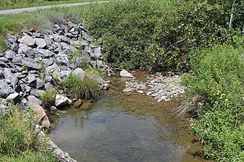
Lick Run (Little Fishing Creek tributary) facts for kids
Quick facts for kids Lick Run |
|
|---|---|

Lick Run in its lower reaches
|
|
| Physical characteristics | |
| Main source | valley in Jordan Township, Lycoming County, Pennsylvania between 1,240 and 1,260 ft (380 and 380 m) |
| River mouth | Little Fishing Creek in Pine Township, Columbia County, Pennsylvania 705 ft (215 m) 41°09′22″N 76°31′13″W / 41.15609°N 76.52026°W |
| Length | 5.2 mi (8.4 km) |
| Basin features | |
| Progression | Little Fishing Creek → Fishing Creek → Susquehanna River → Chesapeake Bay |
| Basin size | 4.40 sq mi (11.4 km2) |
Lick Run is a small stream, also called a tributary, that flows into Little Fishing Creek. It's located in Pennsylvania, USA, passing through Lycoming and Columbia counties. This stream is about 5.2 miles (8.4 kilometers) long. It travels through Jordan Township in Lycoming County and Pine Township in Columbia County. The area of land that drains into Lick Run, called its watershed, is about 4.40 square miles (11.4 square kilometers). The whole area around Lick Run is known as a Coldwater Fishery, meaning it's a great place for fish that like cold water. Part of the stream is even special, called Class A Wild Trout Waters, where wild trout live. At least one bridge crosses over Lick Run.
Contents
Where Does Lick Run Flow?
Lick Run starts in a valley in Jordan Township, Lycoming County. It flows almost straight south for about a mile. During this part of its journey, it leaves Jordan Township and Lycoming County.
After leaving Lycoming County, Lick Run enters Pine Township in Columbia County. Here, the stream turns towards the south-southwest. The valley around it becomes deeper. After about another mile, it crosses Pennsylvania Route 42. Then, it turns almost directly south, flowing very close to Route 42. The stream continues south for several miles. It receives water from many smaller, unnamed streams along the way. Eventually, it turns south-southeast and crosses Pennsylvania Route 42 again. A short distance further downstream, Lick Run meets Little Fishing Creek.
Lick Run joins Little Fishing Creek about 12.02 miles (19.34 kilometers) before Little Fishing Creek reaches its own end.
Geography of the Stream
The land around where Lick Run joins Little Fishing Creek is about 705 feet (215 meters) above sea level. Where the stream begins, its elevation is higher, between 1240 feet (378 meters) and 1260 feet (384 meters).
The Lick Run Watershed
The watershed of Lick Run covers an area of about 4.40 square miles (11.4 square kilometers). This means all the rain and snow that falls in this area eventually flows into Lick Run. The stream is located in the Lairdsville area, as mapped by the United States Geological Survey. The small community of Sereno is also found near the stream.
History and Name of Lick Run
Lick Run was officially added to the Geographic Names Information System on August 2, 1979. This system helps keep track of names for places like streams.
A bridge that carries Pennsylvania Route 42 over Lick Run was built in 1987. This bridge is about 1.25 miles (2.01 kilometers) north of the community of Iola. It is 44.0 feet (13.4 meters) long.
Lick Run gets its name from a natural salt lick that was once found nearby. A salt lick is a place where animals go to lick salt and other minerals from the ground.
Animals and Nature in Lick Run
The Pennsylvania Fish and Boat Commission has given Lick Run a special title: Class A Wild Trout Waters. This special section runs from where the stream starts down to where a road called T-645 meets Pennsylvania Route 42. This part of the stream is about 2.2 miles (3.5 kilometers) long. It is home to brook trout, which are a type of fish. The entire area that drains into Lick Run is also known as a Coldwater Fishery. This means the water is cold enough for fish that prefer cooler temperatures to live and thrive.
 | William Lucy |
 | Charles Hayes |
 | Cleveland Robinson |

