
Little Fishing Creek facts for kids
Quick facts for kids Little Fishing Creek |
|
|---|---|

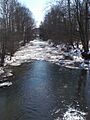
Little Fishing Creek looking downstream in Millville
|
|
| Physical characteristics | |
| Main source | Huckleberry Mountain in Davidson Township, Sullivan County, Pennsylvania between 1,620 and 1,640 feet (490 and 500 m) |
| River mouth | Fishing Creek in Mount Pleasant Township, Columbia County, Pennsylvania and Bloomsburg, Pennsylvania 479 ft (146 m) |
| Length | 23.1 mi (37.2 km) |
| Basin features | |
| Progression | Fishing Creek → Susquehanna River → Chesapeake Bay |
| Basin size | 68.1 sq mi (176 km2) |
| Tributaries | |
Little Fishing Creek is a cool stream in Pennsylvania. It flows through Sullivan County, Lycoming County, and Columbia County. This creek is about 23.5 miles (37.8 km) long. It flows through eight different townships.
The land area that drains into the creek, called its watershed, is about 68.1 square miles (176.4 km2). Little Fishing Creek has six named smaller streams, called tributaries, that flow into it. The biggest ones are Spruce Run and West Branch Run.
The area around the creek has interesting rock formations. These include the Chemung Formation and the Hamilton Group. A large part of the land around the creek is covered by forests. Important roads like Pennsylvania Route 42 also run through the area.
People started settling near Little Fishing Creek a long time ago. The first European settlers arrived in the 1760s or 1770s. More settlers came in the 1790s. In the past, many sawmills, woolen mills, and tanneries used the creek's water. Several covered bridges were also built over it.
Little Fishing Creek is very special. Some parts of it are called "Exceptional Value" streams. This means they are very clean and important for nature. Also, parts of the creek and one of its tributaries are great places for wild trout. You can even go canoeing on some parts of the creek!
Contents
Where Does Little Fishing Creek Flow?

Little Fishing Creek starts high up on Huckleberry Mountain. This mountain is in Davidson Township, Sullivan County. The creek flows south and quickly leaves Sullivan County.
Then, it enters Jordan Township in Lycoming County. Here, it keeps flowing south. It then turns southeast and crosses two main roads: Pennsylvania Route 118 and Pennsylvania Route 239. After this, it leaves Lycoming County.
Next, Little Fishing Creek enters Jackson Township in Columbia County. It flows southeast along the edge of Jackson Township. Then, it turns southwest, still following the border, and goes past Huckleberry Ridge. The creek then flows along the border between Pine Township and Greenwood Township.
After a few miles, it flows next to Pennsylvania Route 42. It also gets water from a tributary called Branch Run. The creek then passes by the town of Millville. It continues flowing south, still near Pennsylvania Route 42. Downstream from Millville, it crosses Pennsylvania Route 254.
Further downstream, it passes Eyers Grove. Here, it gets water from Spruce Run and leaves Greenwood Township. The creek then flows along the western edge of Mount Pleasant Township. It continues to flow next to Pennsylvania Route 42.
After some distance, the creek passes Mordansville. It reaches the southern border of Mount Pleasant Township a few miles later. Finally, Little Fishing Creek flows into Fishing Creek. This happens at the border between Mount Pleasant Township and Bloomsburg. Little Fishing Creek joins Fishing Creek about 3.86 miles (6.21 km) before Fishing Creek ends.
What Are Little Fishing Creek's Tributaries?
Most of the smaller streams that flow into Little Fishing Creek join it from the right side. The creek has many small tributaries in the narrow valleys of Pine Township.
The main named tributaries are Spruce Run, West Branch Run, Lick Run, Wolfhouse Run, Devil Hole Run, and Little Brier Run. Spruce Run and West Branch Run are the largest. Spruce Run's watershed is 9.80 square miles (25.4 km2). West Branch Run's watershed is 10.20 square miles (26.4 km2).
Water Quality and Flooding
About 2.4 miles (3.9 km) of Little Fishing Creek have some water quality issues. These are caused by tiny germs, called pathogens, from an unknown source.
When it rains a lot, the creek can rise. In Millville, a "caution stage" for flooding is 7 feet (2.1 m). The actual "flood stage" is 10 feet (3.0 m). At Eyers Grove, the caution stage is 5 feet (1.5 m). But in areas with walls built to hold back water (levees), it's 7 feet (2.1 m). The flood stage is 7 feet (2.1 m) without levees and 10 feet (3.0 m) with them.
The amount of rain in the creek's watershed usually ranges from 35 to 45 inches (89 to 114 cm) each year.
Land and Rocks Around the Creek
The land around the mouth of Little Fishing Creek is about 479 feet (146 m) above sea level. Where the creek starts, its elevation is between 1620 feet (494 m) and 1640 feet (500 m) above sea level.
Little Fishing Creek forms a natural border between five pairs of townships in Columbia County. These include Jackson and Pine Townships, and Greenwood and Pine Townships.
One type of soil found near the creek is called the Middlebury Series. This soil can be deep and drain well, or it can be poorly drained. All the rocks in the creek's watershed are either shale or sandstone. You can see rock formations of the Chemung Formation near the creek. There are also many rocky, shallow areas in the creek called riffles.
The Greenwood Valley is a valley that runs between Little Fishing Creek and Green Creek. The land around Little Fishing Creek is described as "rough and hilly." The watershed has narrow valleys with steep, high hills around them. The creek's path is winding, not straight.
The Creek's Watershed
The entire area that drains into Little Fishing Creek is called its watershed. It covers about 68.1 square miles (176.4 km2). The creek's mouth is in the Bloomsburg area on maps. Its source is in the Elk Grove area. The creek also flows through the Benton, Lairdsville, and Millville map areas.
Most of the watershed is in Columbia County. However, a large part of the northwest is in Lycoming County. The very northern part is in Sullivan County. This watershed is part of the larger Lower North Branch Susquehanna River drainage basin.
Much of the land in the watershed is covered by forests. There is also a lot of farmland, especially in the northwest and south. Some small areas have buildings and towns. About 64.5 percent of the land is forest, and 34.7 percent is farmland.
Pennsylvania Route 42 follows Little Fishing Creek for a long way. But between Millville and Eyers Grove, the creek is a bit further from the road. Important towns in the watershed include Millville, Iola, Eyers Grove, and Mordansville.
History and Uses of Little Fishing Creek

Little Fishing Creek was officially named on August 2, 1979. It is called "Little Fishing Creek" because it is smaller than Fishing Creek, which it flows into. Sometimes, it is also called Hemlock Creek.
The first settlers likely arrived in the valley of Little Fishing Creek before 1774. Some might have been there as early as 1769. The upper parts of the creek were settled much later than other nearby valleys.
Several covered bridges cross Little Fishing Creek.
- The Creasyville Covered Bridge was built in 1881. It is 44.5 feet (13.6 m) long.
- The Jud Christie Covered Bridge No. 95 was built in 1876. It is 53 feet (16 m) long.
- The Sam Eckman Covered Bridge No. 92 was built in 1876. It is 66 feet (20 m) long.
- The Wanich Covered Bridge No. 69 was built in 1844. It is 98 feet (30 m) long.
Many other bridges have also been built over the creek over the years. The newest bridges were built in 1974, 1990, and 2009.
In the 1790s, John Mordan settled on Little Fishing Creek. He built the first sawmill in Mount Pleasant Township right on the creek. Many other settlers came to live near his mill, and the area became known as Mordansville. There was also once a small flour mill on an island in the creek.
Little Fishing Creek provides water for nearby towns like Millville. In the past, people dug for slate and limestone near the creek. In the early 1900s, there were mills that made wool and tanneries that processed animal hides. Farming was also common. The creek also powered several small flour mills.
Animals and Plants
The water in Little Fishing Creek is very clean and special. Upstream of Lick Run, it's called "Exceptional Value waters." This means it's super important for nature. It's also a "Migratory Fishery," which means fish travel through it. Downstream of Lick Run, it's a "Coldwater Fishery" and still a "Migratory Fishery."
The Pennsylvania Fish and Boat Commission says that Little Fishing Creek is a "Class A Wild Trout Waters" from its start down to Talmar Road. This is a stretch of about 4.3 miles (6.9 km). Part of its tributary, Lick Run, is also great for wild trout.
You can find many Ruffed grouse (a type of bird) along Little Fishing Creek north of Iola. They also live on Spruce Run, another tributary. The creek also has a good "riparian buffer" in most of Jackson Township. This means there are healthy plants and trees along the creek banks.
Fun Activities on the Creek
You can go canoeing on about 11.4 miles (18.3 km) of Little Fishing Creek. The best time to go is when snow is melting or within two days after heavy rain. The creek's difficulty for canoeing is rated as 1, which is easy.
One guide describes the scenery along the creek as "good to poor." He also says the creek "does not do justice to the beautiful countryside through which it flows."
Images for kids
-
Little Fishing Creek looking downstream in Millville
-
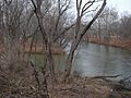
The mouth of Little Fishing Creek (left) where it meets Fishing Creek
-
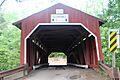
Wanich Covered Bridge No. 69, a historic covered bridge over the creek
