
Devil Hole Run facts for kids
Quick facts for kids Devil Hole Run |
|
|---|---|

Devil Hole Run from Devil Hole Run Road
|
|
| Other name(s) | Devil's Hole Run |
| Physical characteristics | |
| Main source | small pond in Pine Township, Columbia County, Pennsylvania between 1,260 and 1,280 feet (380 and 390 m) |
| River mouth | Little Fishing Creek on the border between Pine Township, Columbia County, Pennsylvania and Greenwood Township, Columbia County, Pennsylvania 853 ft (260 m) 41°11′30″N 76°28′47″W / 41.1917°N 76.4796°W |
| Length | 2.7 mi (4.3 km) |
| Basin features | |
| Progression | Little Fishing Creek → Fishing Creek (North Branch Susquehanna River) → Susquehanna River → Chesapeake Bay |
| Tributaries |
|
Devil Hole Run (also known as Devil's Hole Run) is a small stream in Columbia County, Pennsylvania, in the United States. It is a tributary (a smaller stream that flows into a larger one) of Little Fishing Creek. The stream is about 2.7 miles (4.3 km) long. It flows through Pine Township.
Most of the land around Devil Hole Run is covered by forest. This area is considered a "Locally Significant Area" because of its natural importance. The stream is home to wild trout. You can also find many hemlock trees nearby.
Contents
Where Does Devil Hole Run Flow?

Devil Hole Run starts in a small pond in Pine Township. This is close to the border of Columbia County and Lycoming County.
The stream first flows south-southeast. Then it turns south. It crosses Wolf House Hollow Road as it continues. As it moves downstream, its valley gets deeper.
After flowing for more than two miles, it meets its only named tributary, Kline Hollow Run. A tributary is a smaller stream that flows into a larger one. From there, Devil Hole Run turns south and crosses Devil Hole Run Road. It then leaves its valley and turns southeast. A short distance later, it joins Little Fishing Creek. This meeting point is on the border between Pine Township and Greenwood Township.
What Streams Join Devil Hole Run?
The only named stream that flows into Devil Hole Run is Kline Hollow Run. It joins Devil Hole Run closer to its end.
Understanding the Stream's Environment
The land around Devil Hole Run is known as Devil's Hole Hollow. The stream's mouth is about 853 feet (260 m) above sea level. Its source is higher, between 1,260 feet (380 m) and 1,280 feet (390 m) above sea level.
Devil Hole Run is mostly surrounded by a large, untouched forest. Only small private roads are close to the stream. This helps keep the area natural.
The water in Devil Hole Run stays cool because of the many shrubs nearby. This cool water has a lot of dissolved oxygen. Dissolved oxygen is important for fish and other water creatures to breathe.
The Story Behind the Name
Devil Hole Run was officially added to the Geographic Names Information System on August 2, 1979. This system keeps track of names for places in the United States.
The stream got its name because of its "treacherous waters." Also, the area around it was described as "Hell-like" and "sinister." This information comes from a book called Columbia County Place Names by Walter M. Brasch.
The Columbia County Natural Areas Inventory suggests that people should not do a lot of logging near Devil Hole Run. This helps protect the natural environment.
Animals and Plants of Devil Hole Run
Wild trout live and reproduce naturally in Devil Hole Run. The stream is listed by the Pennsylvania Fish and Boat Commission as a wild trout stream. This means it's a great place for trout to thrive on their own.
Hemlock trees are very common around Devil Hole Run. There are also small open areas with herbaceous plants. These openings might be wet meadows. They often have different kinds of sedges, shrubs, and wetland plants.
The area around Devil Hole Run is considered a "high quality natural habitat." This is noted in the Columbia County Natural Areas Inventory. It means the environment is healthy and important for many plants and animals.
Images for kids
-
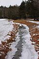
Devil Hole Run from Devil Hole Run Road
