Liffey, Tasmania facts for kids
Quick facts for kids LiffeyTasmania |
|||||||||||||||
|---|---|---|---|---|---|---|---|---|---|---|---|---|---|---|---|

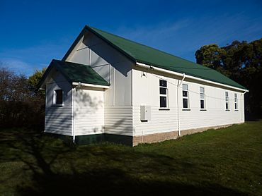
Liffey baptist church
|
|||||||||||||||
| Population | 155 (2016 census) | ||||||||||||||
| Postcode(s) | 7301 | ||||||||||||||
| Location |
|
||||||||||||||
| LGA(s) | Meander Valley, Northern Midlands | ||||||||||||||
| Region | Launceston, Central | ||||||||||||||
| State electorate(s) | Lyons | ||||||||||||||
| Federal Division(s) | Lyons | ||||||||||||||
|
|||||||||||||||
Liffey is a small town and rural area in Tasmania, Australia. It is located in the Launceston and Central parts of the state. Liffey is about 24 kilometers (15 miles) south of the town of Westbury. In 2016, about 155 people lived in Liffey.
The town was named by Captain William Moriarty, who came from Ireland. Liffey is found in a beautiful rainforest area. It sits right on the Liffey River at the bottom of the Great Western Tiers mountains. Nearby towns include Bracknell and Blackwood Creek. One of the most famous spots in the area is Liffey Falls, a stunning waterfall.
Discovering Liffey's Past
Liffey officially became a recognized locality in 1968. A locality is like a specific area or district. The Liffey Post Office opened its doors on August 16, 1887. It served the community for many years before closing in 1973.
Exploring Liffey's Nature
The Liffey River is a key natural feature of the area. It flows through Liffey from the southwest to the northeast. This river is a big part of the local landscape and ecosystem.
Getting Around Liffey
The main road near Liffey is Highland Lakes Road (A5). This road runs along most of Liffey's western edge. It also goes through the southwest corner of the area. Another important road is Route C513, which is also called Liffey Road or Gulf Road. This road comes into Liffey from the northeast. It then travels west along the Liffey River, leading to the parking area for the Lower Liffey Falls.
 | Victor J. Glover |
 | Yvonne Cagle |
 | Jeanette Epps |
 | Bernard A. Harris Jr. |


