
Bracknell, Tasmania facts for kids
Quick facts for kids BracknellTasmania |
|||||||||||||||
|---|---|---|---|---|---|---|---|---|---|---|---|---|---|---|---|

Mountain Views community church
|
|||||||||||||||

Bracknell
Location in Tasmania
|
|||||||||||||||
| Population | 459 (2016 census) | ||||||||||||||
| Postcode(s) | 7302 | ||||||||||||||
| Location |
|
||||||||||||||
| LGA(s) | Meander Valley, Northern Midlands | ||||||||||||||
| Region | Launceston, Central | ||||||||||||||
| State electorate(s) | Lyons | ||||||||||||||
| Federal Division(s) | Lyons | ||||||||||||||
|
|||||||||||||||
|
|||||||||||||||
Bracknell is a small town and rural area in Tasmania, Australia. It is located in the Meander Valley and Northern Midlands regions. The town is about 22 kilometers (14 miles) south-east of Westbury. In 2016, the population of Bracknell was 459 people.
Bracknell was first set up to support the timber industry. Today, it is an important center for the local farming community.
Contents
History of Bracknell
How Bracknell Started
Bracknell was first mapped out before 1859. Town land was sold, but the town really started to grow in the early 1870s. By 1874, Bracknell had a church, two school buildings, a hotel, and other important buildings. The land where the town stands used to belong to the Church of England.
A fun fact about Bracknell is that all its streets are named after women. This tradition started when the town was first planned. The main hotel in town has been open since 1880. It was first called the Enfield Hotel. The local post office opened its doors on August 1, 1872.
Early Churches in Bracknell
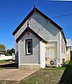
The first Methodist church services in Bracknell were held in a barn around late 1863. As more people joined, a proper church was needed. The first stone for a Primitive Methodist chapel was laid in October 1864. This first church was later moved to make way for the building that stands today.
A house for the minister was added in 1902. This was the same year that many Methodist churches joined together to form the Methodist Church of Australasia. The current church building was started in April 1922 and opened that same year. It cost 1250 Australian pounds to build. In 1977, the church became part of the Uniting Church in Australia and is still used today.
An Anglican church, called St James, also had its first stone laid in December 1931. It was officially opened in April 1932. This church was part of the Church of England parish of Cressy. St James' church later closed down. The Diocese of Tasmania sold the building in 2011.
Geography and Rivers
The Liffey River is a key natural feature of Bracknell. It forms part of the southern border of the area. The river then flows through the town from the south-west to the north-east. After passing through, it forms part of the eastern border of Bracknell.
Roads and Travel
Bracknell is connected by several local roads. Oaks Road (Route C511) comes from the north and ends in the town. Liffey Road, Bracknell Lane, Louisa Street, and Maria Street (Route C513) enter from the north-east. This road goes west through the town and then continues west and south before leaving the area.
Cluan Road (Route C505) starts in Bracknell and heads north-west. Another part of Liffey Road (Route C514) also starts in town and goes south-west. These roads help people travel to and from Bracknell.
Life in Bracknell
Farming and Local Businesses
Bracknell is mainly a farming area with different types of farms. There are no big businesses in town, so many people travel to nearby towns for work. The town itself is next to the Liffey River on its eastern side.
Bracknell has a local store, a service station, and a post office. There are also two community halls and a hotel. The local economy mostly relies on dairy farming, raising livestock, and growing poppies. These poppies are used for Tasmania's special poppy industry.
Schools and Sports
Bracknell Primary School teaches students from grades 1 to 6. In 1950, the school became an "area school," meaning it taught older students too. In the 1960s, it educated students up to grade 9.
Sports are important in Bracknell. A football club was first started in 1899. The town's Australian rules football team, known as the Redlegs, began playing after World War I. They have won three grand finals in local leagues. In 1998, they joined the Northern Tasmanian Football Association. Cricket has also been played in Bracknell since at least 1883. As of 2015, a local team plays in the Northern Midlands Cricket Association.
Local Government and Representation
Bracknell is part of the Meander Valley Council local government area. For state government, it is in the Division of Lyons. For federal government, it is in the Division of Lyons. In the state Legislative Council, it is part of the division of McIntyre.
Images for kids
-
Mountain Views community church
