
Bishopsbourne, Tasmania facts for kids
Quick facts for kids BishopsbourneTasmania |
|||||||||||||||
|---|---|---|---|---|---|---|---|---|---|---|---|---|---|---|---|

The Anglican Church of the Holy Nativity, built in 1844 and opened 25 April 1845
|
|||||||||||||||

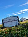
Bishopsbourne
Location in Tasmania
|
|||||||||||||||
| Population | 136 (2016 census) | ||||||||||||||
| Established | 1800s | ||||||||||||||
| Postcode(s) | 7301 | ||||||||||||||
| Location |
|
||||||||||||||
| LGA(s) | Northern Midlands | ||||||||||||||
| Region | Central | ||||||||||||||
| State electorate(s) | Lyons | ||||||||||||||
| Federal Division(s) | Lyons | ||||||||||||||
|
|||||||||||||||
Bishopsbourne is a small farming community in Tasmania, Australia. It's located in the Northern Midlands area. About 19 kilometers (12 miles) southwest of Longford, it's a quiet rural spot.
In 2016, only 136 people lived in Bishopsbourne. The area has a church, a graveyard, and a recreation ground. Most homes and farms are found along Bishopsbourne Road.
Contents
A Glimpse into Bishopsbourne's Past
Who Lived Here First?
For thousands of years, the Panninher people were the first inhabitants of this land. They were part of the Stoney Creek Nation. They lived by their own laws and customs. They used the tilapangka river as a path. They also had camps in the tiered mountains, which they called taytitikithika.
When European Settlers Arrived
In 1821, European settlers came to the area. The British government gave land to farmers and former convicts. Families started building homes and farms. Sometimes, people known as bushrangers would come from the mountains to rob houses. The Panninher people faced many challenges. They bravely tried to protect their land. Sadly, they were forced to leave their homes.
The name Bishopsbourne means 'bishop's villa by the stream.' The town's official boundaries were set in 1848.
Christ College: An Early School

Australia's oldest university-level school, Christ College, opened in Bishopsbourne in 1846. It was designed like the famous Oxford and Cambridge universities in England. At its busiest, 110 male students studied there. The college had a chapel, a library, and even a cricket oval. The first games of Rugby football in Australia were played here! The school closed in 1856. It later moved to Hobart.
The Bush Inn Hotel
A man named William Webb opened a hotel called the "Bush Inn." It was very successful for a while. People said it was the most profitable hotel in Tasmania. But business slowed down, and it closed in 1896. The building later became a local store and post office. Today, it is a private home.
Bishopsbourne in the Early 1900s
By 1904, Bishopsbourne was known as a farming town. It even had its own railway station. The town also had a church, a school, a police station, and a blacksmith. The old Bush Inn hotel was then known as a "coffee palace."
In 1918, a special row of trees was planted. This was called a soldiers avenue. It honored soldiers and was attended by the Premier of Tasmania, Walter Lee, and his wife.
Sports and Community
In 1941, an athlete named Mick Goss broke a world record in running. Later, in 1946, land was bought to build a community hall. New sports fields for cricket and football were also created. These fields were ready by 1947. Bishopsbourne has a cricket team that has been playing for about 70 years!
The Bishopsbourne Post Office opened in 1846 and closed in 1976. Bishopsbourne officially became a "locality" in 1966.
Bishopsbourne's Landscape
What's the Land Like?
Bishopsbourne is mostly farmland now. Long ago, it was covered in natural grasslands. The area is in the Midlands region. This means it has very warm summers. But it also has some of Tasmania's coldest winters, often with frost. The Liffey River forms the western edge of the area.
Getting Around Bishopsbourne
Main Roads
Route C513, also known as Liffey Road or Bishopsbourne Road, runs through the area. Another road, Route C518, starts from C513 and goes east.
Gallery
-
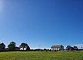
Church of the Holy Nativity, Bishopsbourne
-
field of the Church of the Holy Nativity, Bishopsbourne
-
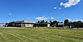
Bishopsbourne Community Centre Recreation Grounds


