Lincoln, Pennsylvania facts for kids
Quick facts for kids
Lincoln, Pennsylvania
|
|
|---|---|
|
Borough
|
|
| Borough of Lincoln | |

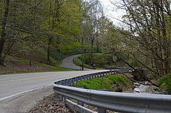
Wylie Run and Lovedale Road
|
|

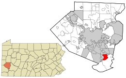
Location in Allegheny County and the state of Pennsylvania.
|
|
| Country | United States |
| State | Pennsylvania |
| County | Allegheny |
| Borough | February 6, 1958 |
| Government | |
| • Type | Mayor-Council |
| Area | |
| • Total | 5.01 sq mi (12.99 km2) |
| • Land | 4.80 sq mi (12.43 km2) |
| • Water | 0.21 sq mi (0.55 km2) |
| Elevation | 1,122 ft (342 m) |
| Population
(2020)
|
|
| • Total | 932 |
| • Density | 194.17/sq mi (74.97/km2) |
| Time zone | UTC-5 (Eastern (EST)) |
| • Summer (DST) | UTC-4 (EDT) |
| ZIP codes |
15133, 15135, 15037
|
| FIPS code | 42-43408 |
Lincoln is a small town, also known as a borough, located in Allegheny County, Pennsylvania, United States. In 2020, about 932 people lived there.
Even though Lincoln is a borough, it doesn't have its own post office. Instead, people in Lincoln use three different ZIP codes for their mail. The ZIP code 15133 is for the northern part of the borough, which is close to Liberty. The eastern part, near the city of McKeesport, uses 15135. For the rest of Lincoln, the ZIP code is 15037, and mail is addressed to Elizabeth.
Contents
History of Lincoln
Lincoln was named after the famous American president, Abraham Lincoln. It officially became a borough on February 6, 1958. Before that, it was known as Lincoln Township. This change happened after a part of the township wanted to join a nearby borough called Liberty.
A special natural area called Dead Man's Hollow is partly located within Lincoln. This conservation area covers about 450 acres of land.
Where is Lincoln Located?
Lincoln is found at coordinates 40°17′27″N 79°51′5″W / 40.29083°N 79.85139°W. It is surrounded by several other towns and natural features. To the northwest, you'll find Glassport. Liberty is to the north, and Versailles is to the northeast.
To the east and south, Lincoln borders Elizabeth Township and the Youghiogheny River. To the west, it's next to Jefferson Hills, Clairton, and the Monongahela River.
The borough covers a total area of about 5.0 square miles (13 km2). Most of this area, about 4.8 square miles (12 km2), is land. The remaining 0.2 square miles (0.52 km2), which is about 4.57% of the total area, is water.
Schools in Lincoln
Students in Lincoln attend schools that are part of the South Allegheny School District. This school district also serves students from the nearby towns of Liberty, Glassport, and Port Vue.
Population Changes Over Time
The number of people living in Lincoln has changed over the years. Here's a look at the population from different census counts:
| Historical population | |||
|---|---|---|---|
| Census | Pop. | %± | |
| 1940 | 1,015 | — | |
| 1950 | 1,467 | 44.5% | |
| 1960 | 1,686 | 14.9% | |
| 1970 | 1,885 | 11.8% | |
| 1980 | 1,428 | −24.2% | |
| 1990 | 1,187 | −16.9% | |
| 2000 | 1,218 | 2.6% | |
| 2010 | 1,072 | −12.0% | |
| 2020 | 932 | −13.1% | |
| Sources: | |||
Famous People from Lincoln
- Sylvia Williams was a notable person from Lincoln. She was a museum director and an expert in African art.
See also
 In Spanish: Lincoln (Pensilvania) para niños
 | Shirley Ann Jackson |
 | Garett Morgan |
 | J. Ernest Wilkins Jr. |
 | Elijah McCoy |

