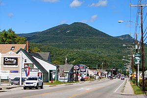
Lincoln (CDP), New Hampshire facts for kids
Quick facts for kids
Lincoln, New Hampshire
|
|
|---|---|
| Country | United States |
| State | New Hampshire |
| County | Grafton |
| Town | Lincoln |
| Area | |
| • Total | 2.74 sq mi (7.09 km2) |
| • Land | 2.69 sq mi (6.97 km2) |
| • Water | 0.04 sq mi (0.11 km2) |
| Elevation | 811 ft (247 m) |
| Population
(2020)
|
|
| • Total | 969 |
| • Density | 359.96/sq mi (139.00/km2) |
| Time zone | UTC-5 (Eastern (EST)) |
| • Summer (DST) | UTC-4 (EDT) |
| ZIP code |
03251
|
| Area code(s) | 603 |
| FIPS code | 33-41780 |
| GNIS feature ID | 2629725 |
Lincoln is a small community in New Hampshire, United States. It's often called a "census-designated place" (CDP), which means it's a special area defined for counting people. Lincoln is the main village within the larger town of Lincoln. In 2020, about 969 people lived in this part of Lincoln. The whole town of Lincoln had 1,631 residents. It's located in Grafton County.
Contents
Exploring Lincoln's Geography
This community is found in the southwestern part of the town of Lincoln. It sits between two rivers, the Pemigewasset River and its East Branch. Lincoln is also on the southern side of the famous White Mountains.
Natural Borders and Nearby Towns
To the south, Lincoln borders the town of Woodstock. The East Branch of the Pemigewasset River forms its border to the southeast. Pollard Brook is to the east, and Little Coolidge Mountain is to the north. The Pemigewasset River and Interstate 93 border Lincoln to the west. A part of Lincoln is even inside the beautiful White Mountain National Forest. Loon Mountain, which is 3,065 feet tall, overlooks Lincoln from the south.
Main Roads and Connections
New Hampshire Route 112 is the main road that goes through Lincoln. As it enters the national forest to the east, it becomes the Kancamagus Highway. This highway stretches 36 miles east to Conway.
Interstate 93 connects with Route 112 at Exit 32, just south of Lincoln in North Woodstock. I-93 goes north through Franconia Notch for 22 miles to Littleton. It also goes south for 62 miles to Concord, which is the capital city of New Hampshire.
Land and Water Area
The Lincoln CDP covers a total area of about 7.1 square kilometers (2.74 square miles). Most of this area, about 7.0 square kilometers (2.69 square miles), is land. Only a small part, about 0.1 square kilometers (0.04 square miles), is water.
People of Lincoln: Demographics
The number of people living in Lincoln has changed a little over the years. In 2010, there were 993 people. By 2020, the population was 969.
Households and Families
In 2010, there were 486 households in Lincoln. A household is a group of people living together. Out of these, 258 were families. Many homes, about 63.5%, were empty, with 772 of them being used only for vacations or recreation.
Most of the people in Lincoln were white (99.1%). A very small number were African American, Asian, or from two or more races. About 0.4% of the population identified as Hispanic or Latino.
Age Groups in Lincoln
The people in Lincoln come from different age groups.
- 17.9% were under 18 years old.
- 6.2% were between 18 and 24 years old.
- 21.2% were between 25 and 44 years old.
- 33.9% were between 45 and 64 years old.
- 20.5% were 65 years old or older.
The average age in Lincoln was about 48.5 years.
Income and Economy
From 2011 to 2015, the average yearly income for a household in Lincoln was estimated to be $37,000. For families, the average income was higher, around $56,060. The per capita income, which is the average income per person, was $26,987.
A small number of people and families lived below the poverty line. This included 6.0% of people under 18 and 3.1% of people 65 or older.
See also
 In Spanish: Lincoln (condado de Grafton) para niños


