
List of National Historic Sites of Canada in British Columbia facts for kids
This is a list of National Historic Sites (which are called Lieux historiques nationaux in French) in the Canadian province of British Columbia. As of January 2020, there were 100 National Historic Sites in British Columbia. Thirteen of these are managed by Parks Canada (you'll see a beaver icon ![]() next to them). The very first National Historic Sites chosen in British Columbia were Fort Langley and Yuquot in 1923.
next to them). The very first National Historic Sites chosen in British Columbia were Fort Langley and Yuquot in 1923.
Many important historical events and people are also remembered across British Columbia. They are marked with special plaques, just like the National Historic Sites. These markers don't always say if they are for a place, an event, or a person. For example, the Rideau Canal is a Site, but the Welland Canal is an Event. The plaque for John Macdonell is there because his home, Glengarry House, is a National Historic Site, not because he is a National Historic Person. The plaque for John Guy marks an Event: the Landing of John Guy.
The names used in this list are the official ones given by the Historic Sites and Monuments Board of Canada. Sometimes, these names might be different from other names for the same places.
Contents
Exploring British Columbia's Historic Treasures
British Columbia is full of amazing places that tell stories about Canada's past. These are called National Historic Sites. They help us learn about important events, people, and ways of life that shaped the country.
What Makes a Place Historic?
A place becomes a National Historic Site because it has special meaning to Canada's history. This could be an old building, a natural area, or even the remains of an ancient village. Each site helps us understand different parts of our heritage, from early settlements and industries to important cultural moments.
Famous Forts and Trading Posts
Many historic sites in British Columbia are old forts and trading posts. These places were very important for trade, exploration, and settlement long ago.
(retouched)(transparent).png)
This site on the Fraser River was a key trading post for the Hudson's Bay Company. In 1858, the colony of British Columbia was officially started here! It's a great place to imagine life during the fur trade era.
This coastal defense site has three old artillery batteries. It shows how important Esquimalt Harbour was for defending the British Empire and Canada.
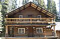
This is a restored fur trade post on Stuart Lake, founded by explorer Simon Fraser. For many years, it was the main office for the Hudson's Bay Company's New Caledonia District.

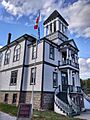
This was the first North-West Mounted Police post in British Columbia, started by Superintendent Sam Steele. It gives us a glimpse into law enforcement in the early days of the province.
Important Buildings and Landmarks
British Columbia also has many historic buildings that show off different architectural styles and important community roles.

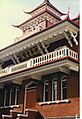
Completed in 1912, this is the oldest surviving Sikh temple in Canada. It played a big part in the early days of Sikh immigration to Canada. It also shows how Sikh traditions mixed with Canadian building styles.
.jpg)
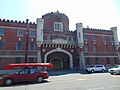
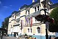
This grand hotel in Victoria was built for the Canadian Pacific Railway. It's a famous example of the Château-style architecture in Canada.

Finished in 1938, this bridge is a major link in Greater Vancouver. When it was built, it was the longest suspension bridge in the entire British Empire!

Known as the "Grand Old Lady of Granville," this theatre is one of the few old movie palaces in Canada that still looks much like it did when it opened in 1927.
.jpg)
Built in 1913, this theatre hosted plays, music, and vaudeville shows. It's now one of Canada's best-preserved large theatres.
- SS Moyie
_at_Kaslo_2008.jpg)
This old steam-powered paddle steamer, built in 1898, is now dry-docked in Kaslo. When it retired, it was the oldest Canadian-built paddle wheeler still in service!

The St. Roch is a restored Royal Canadian Mounted Police schooner. It was the first ship to sail from the Pacific Ocean to the Atlantic Ocean through the Northwest Passage! You can see it at the Vancouver Maritime Museum.

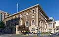
Completed in 1890, this building is a great example of the Second Empire architectural style in western Canada.
Nature and Indigenous Heritage
Many sites also highlight British Columbia's natural beauty and the rich history of its Indigenous peoples.

This historic town was the heart of the Cariboo Gold Rush, which really helped British Columbia grow. It was once a ghost town, but it has been restored since 1958.
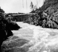
This old trail through the Coast Mountains was used by thousands of prospectors during the Klondike Gold Rush. It connects British Columbia with Alaska.
- Chinese Cemetery at Harling Point

This cemetery in Oak Bay has the largest collection of Chinese burial features from before 1950 in Canada. It's a special memorial to the early Chinese-Canadian immigrants.

This historic area in Vancouver has buildings mostly from 1886 to 1914. It's a great example of how old city centers were saved by heritage groups in the 1970s.
Also known as Kitwanga Fort, this site has the remains of a fortified Gitwangak village. It's linked to old legends about the warrior Nekt.
This group of wooden buildings on a wharf was used for processing and canning fish. It shows how important the fishing industry was on Canada's West Coast.
This pass is a major route for trains and highways through the Rocky Mountains. It offers some of the most amazing mountain views in the world!
This Huu-ay-aht village and fortress is the only known First Nations village on the British Columbia Coast that still has important traditional buildings standing.

A canyon settled by Aboriginal peoples for about 5000 years. It was the site of two Tsimshian villages in the 1800s that controlled trade in the area.
Also known as Ninstints or SGang Gwaay Llanagaay, this site has the remains of Haida longhouses and totem poles. It's also a UNESCO World Heritage Site, meaning it's recognized as important to the whole world!

This memorial centre is on the site of a former internment camp. It was built to house Japanese Canadian families who were forced to leave the West Coast during World War II.
- North Pacific Cannery

This salmon cannery is a well-preserved collection of buildings that show over 100 years of the West Coast fishing industry.
This huge public park in Vancouver was once a First Nations ceremonial site and a British military reserve. It's a perfect example of a large city park in Canada.

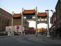
One of the oldest and largest Chinatowns in Canada, known for its unique "recessed balcony" style of buildings.

This is the oldest surviving Chinatown in Canada. It still has many of its original historic buildings.
- Whaler's Shrine Site

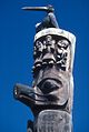
This was the original location of a very important monument linked to the Nuu-chah-nulth people's whaling traditions. The shrine was moved in 1905 and is now in a museum in New York.

This is an ancient living site of the Stó:lo peoples, dating back thousands of years.

This place was the center of the Mowachaht/Muchalaht First Nations' world. It was also the first place where Europeans met Indigenous people on Canada's west coast, and where the Nootka Conventions were signed.
Images for kids
-
223 Robert Street
-
Bay Street Drill Hall
-
Begbie Hall
-
Plaque outside the Binning Residence
-
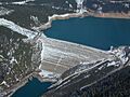
The Boat Encampment site now sits under the water of the reservoir created by the Mica Dam
-
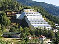
Britannia Mines Concentrator
-
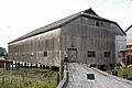
Britannia Shipyard
-
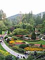
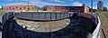
View of the Sunken Garden
-
Chee Kung Tong Building
-
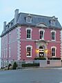
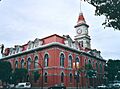
The Chilliwack City Hall in 1912
-
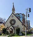
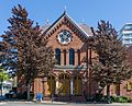
Church of Our Lord, Victoria
-
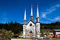
Church of the Holy Cross
-
The red brick front facade of the synagogue
-
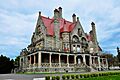
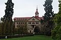
Exterior view of Craigdarroch Castle
-
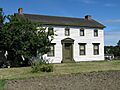
Exterior view of Craigflower Manor House
-
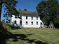
Exterior view of Craigflower Schoolhouse
-
Detail of the Dominion Astrophysical Observatory front facade
-
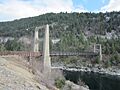
Doukhobor Suspension Bridge
-
Front of Emily Carr House
-
E&N Turntable and Roundhouse
-
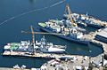
Aerial photograph of Canadian warships docked at Her Majesty's Canadian (HMC) Dockyard
-
The southeast view of Government House from below, showing the bow window of the Ballroom at left
-
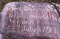
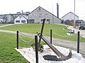
Inscription on a stone at the end of Alexander Mackenzie's 1792-1793 Canada crossing from the Peace River to the Pacific Ocean coast
-
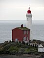
Exterior view of the Fisgard Lighthouse and the Pacific Ocean
-

Exterior view of the Vancouver Art Gallery
-
Former Victoria Law Courts
-
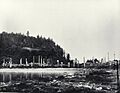
Site of Fort Alexandria in the 1910s
-
Fort McLeod
-
Watercolour of Fort Victoria in 1860
-
View of Gitwangak Battle Hill with mountains in background
-
An exterior view of the Gulf of Georgia Cannery in Steveston
-
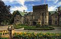
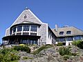
An exterior view of Hatley Castle
-
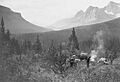
Black and white photograph of pack horses and a camp in the Howse Pass in 1902
-
An exterior view of Kaslo Municipal Hall
-
Kitselas Canyon in the 1910s
-
Kitwankul
-
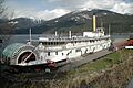
Moyie in 2008
-
Front and side facades of Old Custom House
-
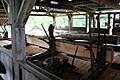
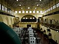
Interior of McLean Mill
-
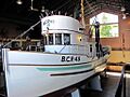
Motor Vessel BCP 45
-
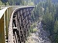
Myra Canyon Section of the Kettle Valley Railway in 2003
-
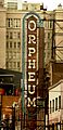
The sign above the Orpheum's marquee
-
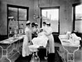
Pemberton Memorial Operating Room
-
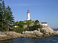
Point Atkinson Lighthouse as seen from the water
-
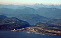
Aerial photograph of Powell River
-
Roger Building
-
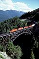
A Canadian Pacific Railway freight eastbound over the Stoney Creek Bridge.
-
Black and white photograph of the Rossland Court House in 1909
-
Exterior view of the Royal Theatre
-
A view of the Mission Reserve circa 1886 with view of spire of church prior to 1909 remodelling
-
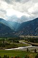
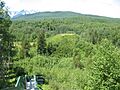
The Similkameen River Valley
-
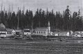
Skedans in 1878
-
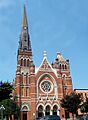
Front facade of St. Andrew's Cathedral
-
View of St Ann's Academy and surrounding gardens
-
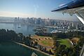
Aerial view of Stanley park and Vancouver
-
The Stave Falls former powerhouse
-
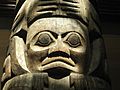
Haida totem pole from Tanu, Haida Gwaii
-
Twin Falls Tea House
-
Union Club
-
Vancouver Japanese Language School
-
Vancouver's Chinatown
-
Exterior view of Victoria City Hall
-
The Chinese Consolidated Benevolent Association building in Victoria's Chinatown
-
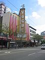
Front facade and marquee of the Vogue Theatre


.jpg)


_-_06.JPG)


_(cropped).jpg)


Former National Historic Site in BC
There was once another National Historic Site in British Columbia that is no longer recognized:
- Kamloops Junction Railroad Station National Historic Site
This train station was taken off the list in 1976 because it was torn down.
See also
