
Chilkoot Trail facts for kids
Quick facts for kids Chilkoot trail |
|
|---|---|

1. Dyea, 2. Finnegan's Point, 3. Canyon City, 4. Pleasant Camp, 5. Sheep Camp, 6. Scales, 7. Chilkoot Pass, 8. Stone Crib, 9. Happy Camp, 10. Deep Lake, 11. Lake Lindemann, 12. Bare Loon Lake, 13. Lake Bennett
|
|
| Length | 33 miles |
| Summit | Chilkoot Pass; 1067 m / 3,525 feet |
| Legacy | Trail for Klondike Gold Rush (1896–1899) |
| Use | Tourist attraction |
| Location | Southeast Alaska - Northwest British Columbia |
| Port | Skagway |
 |
|
| Official name: Chilkoot Trail National Historic Site of Canada | |
| Designated: | 1987 |
| Official name: Chilkoot Trail and Dyea Site | |
| Designated: | 1978 |
The Chilkoot Trail is a famous 33-mile (53 km) path through the Coast Mountains. It stretches from Dyea, Alaska, in the United States, all the way to Bennett, British Columbia, in Canada.
This trail was super important in the late 1890s. It was the main way to reach the Yukon goldfields from the coast. But by 1899, a new railway was built from Skagway, making the Chilkoot Trail less used. Today, it's a special historic site. The U.S. named it a National Historic Landmark in 1978. Canada also made it a National Historic Site in 1987. In 1998, both countries joined their parts of the trail to create the Klondike Gold Rush International Historical Park.
Contents
History of the Chilkoot Trail
Early Use by Indigenous People
Long before the gold rush, the Tlingit people used the Chilkoot Trail. It was a vital trade route for them. They traded goods from the coast with people living inland.
Over time, as more American settlers arrived, the Tlingit trading system changed. Explorers and people looking for gold, called prospectors, slowly started using the Chilkoot Trail too.
The Klondike Gold Rush Era

The Klondike Gold Rush (1896–1899) made the Chilkoot Trail very popular. Thousands of people wanted to find gold near Dawson City in Yukon. The Chilkoot Trail was the shortest and cheapest way to get there from the coast.
Another main route was the White Pass trail, also starting near Skagway. The White Pass was longer but less steep. The Chilkoot was shorter but much harder. Skagway was the main port for both trails because it had a deep harbor. Dyea, where the Chilkoot Trail began, was built on a shallow river delta.
Prospectors would take small boats to Dyea. Soon, both Skagway and Dyea became busy tent cities. Exciting news about gold made many people leave their homes and jobs. They traveled by ship up the Inside Passage to Skagway.
The "Ton of Goods" Rule
The journey was very tough. Many prospectors were not prepared for the difficult land and harsh weather. So, the North-West Mounted Police (now the Royal Canadian Mounted Police) made a rule. To enter Canada, each prospector had to carry at least one ton (about 900 kg) of supplies. This was enough food and gear for one year. (See also: Klondike supply list).
Prospectors moved their gear slowly, from one camp to the next. They often carried it themselves, piece by piece. Some bought pack animals, but this was more common on the White Pass trail. Many also paid Tlingit people to carry their heavy loads for them.
Chilkoot Trail Tramways
As more and more supplies needed to be moved, special companies built tramways. These were like cable cars that carried tons of gear over the heads of the prospectors every day.
By the busiest time of the Chilkoot Trail, there were five different tramway systems. They competed to move the huge amounts of gear. Many of these tramways were amazing engineering achievements for their time.
After the Gold Rush
After the Klondike Gold Rush ended, the Chilkoot Trail became mostly empty. New prospectors could now take a White Pass and Yukon Route narrow-gauge railroad. This train went all the way to Whitehorse, Yukon, in the Yukon Territory.
In 1969, the U.S. and Canadian governments decided to make the Chilkoot Trail an international park. The U.S. part became the Klondike Gold Rush National Historical Park in 1976. It included parts of Seattle, sites in Skagway, the old town of Dyea, and the U.S. part of the Chilkoot Trail.
The Canadian part was named Chilkoot Trail National Historic Site. Finally, in 1998, the dream of an international park came true. The U.S. and Canadian parks joined to form the Klondike Gold Rush International Historical Park.
Hiking the Chilkoot Trail Today

The Chilkoot Trail is now a very popular hiking trail. Many people from Southeast Alaska and the Yukon Territory enjoy it. Tourists from all over the world also come to hike it.
To protect the trail and keep it from getting too crowded, the National Park Service (U.S.) and Parks Canada (Canada) have a permit system. Only 50 backpackers can start the trail each day.
The fees from these permits help pay for trail maintenance crews and park rangers. There are also well-designed campgrounds and signs explaining historical sites. The "official" hiking season is usually from late May to early September. This is when rangers are on duty. The busiest time is from June to August.
Chilkoot Trail Running
The Chilkoot Trail is also a very challenging place for ultra-runners. These are people who run extremely long distances. The fastest known time to complete the trail is 5 hours and 27 minutes.
Chilkoot Trail Route and Attractions
The Chilkoot Trail has many natural and historical spots. If you follow the numbers on the map from south to north, you will walk the same path as the old prospectors. The hike usually takes three to five days. There are special campgrounds where you can stay overnight.
The trail goes through three different climate zones. These are the coastal rainforest, the high alpine (above the trees), and the boreal forest. At the end, the trail connects to the White Pass historical railway, which goes back to Skagway. The following sections highlight important points along the trail.
Coastal Rainforest Zone

The trail starts in Dyea, which is now a ghost town and campground. It's about 15 minutes from Skagway. From the start, the path goes through a coastal rainforest along the Taiya River. The first campsite is Finnegan's Point. This part of the trail is flat and easy to walk.
After Finnegan's Point, the air gets cooler. This is because of the snow and ice in the mountains nearby. Many streams flow down the mountainsides. This part of the trail has the fewest old artifacts to see. The next camp is Canyon City. Many hikers stop here on their first night. The shelter at Canyon City has many items from the gold rush era.
Near the Canyon City campsite are the Canyon City ruins. This was a busy tent city during the gold rush. You can still see old building foundations, a large restaurant stove, and a big boiler. You can reach the ruins by crossing the Taiya River on a suspension footbridge.

After the Canyon City ruins, the trail moves away from the river. The river goes into a small canyon, which is how Canyon City got its name. The trail climbs up the valley wall through a sub-alpine forest. You can still see old telegraph and tram wires next to the trail in many places. This part of the trail was very hard for prospectors.
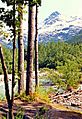
The next landmark is Pleasant Camp. There is a sign at the original site, a bit before the current campground. Pleasant Camp is where the trail meets the Taiya River again. It's a smaller campground. From here, the trail is mostly flat, winding through the forest and over small creeks.
The trail then reaches Sheep Camp. This is the last campground on the American side. It's also the final stop before the tough climb up Chilkoot Pass. It is the biggest campsite on the U.S. side.
After Sheep Camp, before the U.S. ranger station, the trail goes through a large avalanche area. The avalanche cleared out all the old trees, leaving a young, brushy landscape. A short distance past the ranger station, there's a small museum in an old cabin. It has artifacts from the gold rush. Soon after, the forest disappears, and the trail enters a treeless alpine area. Here, you get a great view of the Taiya River valley. As the trail climbs higher, it becomes more defined, often marked by yellow poles in the snow.
High Alpine Zone

You can see the pass from The Scales. This is at the bottom of the "Golden Stairs," the long, difficult climb to the pass. The Scales was a place where freight was weighed again before the final push. Native packers sometimes asked for higher prices here. The Scales also had a small tent city with restaurants, hotels, a saloon, and freight offices. The tough Golden Stairs made many prospectors give up. They often left their ton of equipment behind. Because of this, and the snow that preserves things, you can find many old items here, including parts of wooden buildings.
After The Scales is the final climb to Chilkoot Pass: the famous Golden Stairs. It got its name from the steps that prospectors carefully carved into the snow and ice. At the pass itself, right on the Canada–U.S. border, there's a warming cabin and a Parks Canada warden station. If a group is moving too slowly, the warden or U.S. ranger might offer the cabin for shelter. This prevents groups from getting stuck in the open alpine area between the pass and Happy Camp. Many artifacts are scattered around the Golden Stairs and the ridges near the pass. This includes old, complete (canvas, wood) prefabricated boats.
Stone Crib is about half a mile after the pass. It was the end point for the Chilkoot Railroad and Transport Company's aerial tramway. It was a huge rocky counterweight for the tram. You can still see this wooden structure today, well-preserved by the snow.
The trail then winds past a series of alpine lakes: First Crater Lake, Morrow Lake, and finally Happy Camp.
Boreal Forest Zone

The trail continues past a couple more lakes—Long Lake and Deep Lake—before reaching the tree line. Next to Deep Lake, where the trees start to appear, is another campground.
The Canadian side of the Chilkoot Trail is much drier. This is because it's in the rain shadow of the Coast Mountains. The pine forest that starts at Deep Lake looks very different from the lush temperate rain forest on the U.S. side before Chilkoot Pass.
After Deep Lake, the river flowing out of it runs next to the trail for a short distance. Then it goes into a small canyon. You can see many old boat parts and other boat-related items in this area. The trail then gently goes downhill until you see the turquoise-colored Lake Lindeman. The trail ends its descent at the Lake Lindeman campground, which is the main base for Canadian trail operations.
The trail climbs a steep hill after Lindeman. From here, you get a wide view of the lake and the forest around it. After Lake Lindeman, the trail passes Bare Loon Lake and the Bare Loon Lake campground.
The trail splits after Bare Loon Lake. One path continues to Lake Bennett and the tracks of the White Pass & Yukon Route railroad. The other path, called the Log Cabin cut-off, connects to the Klondike Highway. However, Parks Canada closed this path in 2010.
Bennett has a campground, a White Pass and Yukon Route train station, and several private houses. It also has the only gold rush-era building still standing along the trail today, the renovated St. Andrew's Presbyterian Church. You can see old pier pilings along the lakeshore and various cans and metal items scattered in the woods.
Chilkoot Trail Campgrounds
There are nine official, maintained campgrounds on the Chilkoot Trail. You are only allowed to camp in these places. Hikers must bring their own tents. The cabins at the campgrounds are only for warming up and cooking. You need to bring a backpacking stove for cooking, as open fires are not allowed. You must plan your campground stays in advance.
Besides the camps, there's a U.S. Ranger Station north of Sheep Camp. Rangers there share the history of the pass and give updates on weather and trail conditions before you cross the summit.
Safety on the Chilkoot Trail

Bears are the main safety concern in the park. It's very common for hikers to see them. You cannot bring firearms on the Canadian side of the park. Most groups carry bear spray or bear bangers to scare bears away. Most importantly, both sides of the park require smart bear practices. You must store your food in bear-safe containers or locations.
Weather and the trail itself can also be challenging. There are few risks in the forest parts of the trail. However, once the trail climbs into the alpine area, weather and the elements become more of a concern. Feeling dizzy from heights (vertigo) can also be an issue. The American ranger from Sheep Camp often checks on hikers late in the day. They make sure no groups are struggling to reach Happy Camp and might need emergency shelter.
Klondike Supply List
This list shows the suggested equipment prospectors needed to enter Canada at the summit of Chilkoot Pass between 1897 and 1899. The total weight was one ton. (See also: Klondike era)
- 150 lb. bacon
- 400 lb. flour
- 25 lb. rolled oats
- 125 lb. beans
- 10 lb. tea
- 10 lb. coffee
- 25 lb. sugar
- 25 lb. dried potatoes
- 2 lb. dried onions
- 15 lb. salt
- 1 lb. pepper
- 75 lb. dried fruits
- 8 lb. baking powder
- 2 lb. soda
- ½ lb. evaporated vinegar
- 12 oz. compressed soup
- 1 can mustard
- 1 tin matches (for four men)
- Stove for four men
- Gold pan for each
- Set granite buckets
- Large bucket
- Knife, fork, spoon, cup, and plate
- Frying pan
- Coffee and teapot
- Scythe stone
- Two picks and one shovel
- One whipsaw
- Pack strap
- Two axes for four men and one extra handle
- Six 8-inch (200 mm) files and two taper files for the party
- Draw knife, brace and bits, jack plane, and hammer for party
- 200 feet three-eights-inch rope
- 8 lb. of pitch and 5 lb (2.3 kg). of oakum for four men
- Nails, five lbs. each of 6,8,10 and 12 penny, for four men
- Tent, 10 by 12 feet (3.0 m × 3.7 m) for four men
- Canvas for wrapping
- Two oil blankets to each boat
- 5 yards of mosquito netting for each man
- 3 suits of heavy underwear
- 1 heavy mackinaw coat
- 2 pairs heavy mackinaw trousers
- 1 heavy rubber-lined coat
- 1 doz heavy wool socks
- ½ doz heavy wool mittens
- 2 heavy overshirts
- 2 pairs heavy snagproof rubber boots
- 2 pairs shoes
- 4 pairs blankets (for two men)
- 4 towels
- 2 pairs overalls
- 1 suit oil clothing
- Several changes of summer clothing
- Small assortment of medicines
Images for kids
-
Pleasant Camp
-
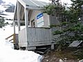
Happy Camp in the early season, 2004
-
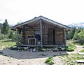
Lake Lindeman campground, 2004
-
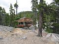
Bare Loon Lake Camp cooking shelter 2016


