
List of National Natural Landmarks in Vermont facts for kids
Vermont is home to 12 amazing places called National Natural Landmarks! These special spots are recognized for their unique natural features, like ancient forests, rare bogs, or incredible geological formations. They help us protect and learn about the natural history of our planet.
Contents
- Discover Vermont's Natural Wonders!
- What are National Natural Landmarks?
- Battell Biological Preserve: An Ancient Forest
- Barton River Marsh: A Wetland Wonderland
- Camel's Hump: Vermont's Iconic Peak
- Cornwall Marsh: Vermont's Largest Red Maple Swamp
- Franklin Bog: A Cold Northern Bog
- Fisher-Scott Memorial Pines: Giants of the Forest
- Gifford Woods: A Northern Hardwood Forest
- Little Otter Creek Marsh: Vermont's Best Marshland
- Lake Willoughby Natural Area: A Glacial Masterpiece
- Molly Bog: A Classic Northern Bog
- Mount Mansfield: Home to Rare Arctic Plants
- Chazy Fossil Reef: An Ancient Underwater World
- Images for kids
Discover Vermont's Natural Wonders!
Vermont has many beautiful and important natural areas. The National Natural Landmark program helps protect some of the very best. These landmarks are like natural treasures, showing us different parts of Earth's history and amazing ecosystems.
What are National Natural Landmarks?
National Natural Landmarks (NNLs) are special places in the United States that have outstanding natural features. They might be home to rare plants or animals, show important geological processes, or be excellent examples of different ecosystems. The program encourages the protection of these sites, whether they are owned by the government, states, or even private citizens.
Battell Biological Preserve: An Ancient Forest
The Battell Biological Preserve was named a National Natural Landmark in 1976. This special place in Addison County is a perfect example of a climax forest in New England. A climax forest is an old, stable forest that has reached its final stage of development, with very old trees and a balanced ecosystem. It's like a natural time capsule!
Barton River Marsh: A Wetland Wonderland
Designated in 1973, the Barton River Marsh in Orleans County is a huge, shallow freshwater marsh. It's considered one of the best and largest marshes in all of New England. Marshes are super important wetlands that provide homes for many kinds of birds, fish, and other wildlife. This landmark is owned by the state, helping to keep it safe for everyone to enjoy.
Camel's Hump: Vermont's Iconic Peak

Camel's Hump became a National Natural Landmark in 1968. Located in Chittenden and Washington counties, this mountain is famous for its unique shape, which looks like a camel's humps! It's also special because it has the second-largest area of alpine tundra in Vermont. Alpine tundra is a cold, treeless biome found at high elevations, similar to what you'd find in the Arctic. Rare plants grow here that can survive the harsh mountain weather. The state owns this beautiful landmark.
Cornwall Marsh: Vermont's Largest Red Maple Swamp
Recognized in 1973, Cornwall Marsh in Addison County is the biggest unbroken red maple swamp in Vermont. Swamps are wetlands dominated by trees, and red maple swamps are known for their vibrant fall colors. This landmark is a mix of state, municipal (town), and private ownership, showing how different groups can work together to protect nature.
Franklin Bog: A Cold Northern Bog
Franklin Bog, designated in 1973, is located in Franklin County. It's a classic example of a cold, northern sphagnum-heath bog. Bogs are wetlands that get most of their water from rainfall, making them very acidic. They are often covered in sphagnum moss and heath plants. Bogs are unique ecosystems that support special plants and animals adapted to these conditions. This bog is privately owned.
Fisher-Scott Memorial Pines: Giants of the Forest
Named a National Natural Landmark in 1976, Fisher-Scott Memorial Pines in Bennington County protects an old-growth stand of white pine trees. Old-growth means these trees are very old and have never been logged. They are giants of the forest, providing important habitats and showing us what forests looked like centuries ago. This landmark is owned by the state.
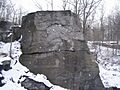
Gifford Woods: A Northern Hardwood Forest
.jpg)
Gifford Woods became a National Natural Landmark in 1980. Found in Rutland County, it's another example of an old-growth, northern hardwood, climax forest. This means it's a very old, stable forest with trees like maple, birch, and beech. It's a great place to see how a natural forest ecosystem works without much human interference. The state owns this landmark.
Little Otter Creek Marsh: Vermont's Best Marshland
Designated in 1973, Little Otter Creek Marsh in Addison County is considered the best large area of marshland in Vermont. Like other marshes, it's a vital wetland habitat for many species. It's owned by a mix of state and private entities, highlighting shared responsibility for conservation.
Lake Willoughby Natural Area: A Glacial Masterpiece

The Lake Willoughby Natural Area was designated in 1967. Located in Orleans County, this lake is the deepest in Vermont! It's also one of the most important and beautiful examples of glacial erosion in the northeastern United States. This means the lake was carved out by massive glaciers moving across the land thousands of years ago. Its steep cliffs and deep waters are a testament to the power of ice. The state owns this stunning natural area.
Molly Bog: A Classic Northern Bog
Molly Bog, named a National Natural Landmark in 1973, is in Lamoille County. It's described as a classic, early successional, cold northern bog. Successional means it's still developing and changing over time. Like Franklin Bog, it's a unique wetland with special plants and conditions. It's owned by a mix of state and private groups.
Mount Mansfield: Home to Rare Arctic Plants

Mount Mansfield became a National Natural Landmark in 1980. As Vermont's highest peak, located in Chittenden and Lamoille counties, it's incredibly diverse. It has a untouched red spruce-balsam fir forest, large areas of alpine tundra, and rare arctic flora (plants) that aren't found anywhere else in the northeast. This makes it a very special place for scientists and nature lovers. The state owns this important landmark.
Chazy Fossil Reef: An Ancient Underwater World

The Chazy Fossil Reef was the most recent addition to Vermont's National Natural Landmarks, designated in 2009. Located in Grand Isle County, this site is home to the oldest known example of a biologically diverse fossil reef in the entire world! Imagine a coral reef, but from millions of years ago, now turned to stone. It shows us what life was like in ancient oceans. This landmark is owned by a mix of federal, state, and private groups.
Images for kids
-
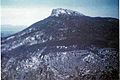
Camel's Hump
-
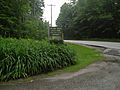
Gifford Woods
-
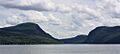
Lake Willoughby
-
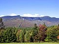
Mount Mansfield
-
Chazy Fossil Reef
