Little Roaring Creek facts for kids
Quick facts for kids Little Roaring Creek |
|
|---|---|

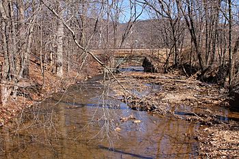
Little Roaring Creek looking downstream
|
|
| Physical characteristics | |
| Main source | hill in southwestern Mayberry Township, Montour County, Pennsylvania 980 to 1,000 feet (300 to 300 m) |
| River mouth | Susquehanna River on the border between Mayberry Township, Montour County, Pennsylvania and Rush Township, Northumberland County, Pennsylvania 440 ft (130 m) 40°56′16″N 76°33′26″W / 40.93775°N 76.55729°W |
| Length | 4.4 mi (7.1 km) |
| Basin features | |
| Progression | Susquehanna River → Chesapeake Bay |
| Basin size | 5.98 sq mi (15.5 km2) |
Little Roaring Creek is a small stream, or tributary, that flows into the big Susquehanna River in Pennsylvania, USA. It runs through parts of Montour County and Northumberland County. The creek is about 4.4 miles (7.1 km) long.
The area of land that drains into the creek, called its watershed, is about 5.98 square miles (15.5 km2). Little Roaring Creek is a special place for fish because it's a coldwater fishery, meaning its water stays cool. It's also a migratory fishery, which means fish travel through it. Long ago, there were at least two mills built along the creek, and today, several bridges cross over it.
Contents
The Creek's Journey
Little Roaring Creek starts on a hill in the southwest part of Mayberry Township, Montour County. It flows west for a short distance. Then it reaches the border between Montour County and Northumberland County.
At this point, the creek turns and flows north-northwest. It stays very close to the county border. The creek travels through a valley for several miles. Eventually, it turns north and slightly east. Soon after leaving its valley, it joins the Susquehanna River. Little Roaring Creek meets the Susquehanna River about 140.88 miles (226.72 km) upstream from where the Susquehanna River flows into the ocean.
Land and Water Around the Creek
The land around where Little Roaring Creek meets the Susquehanna River is about 440 feet (130 m) above sea level. Where the creek begins, its source, the elevation is higher. It is between 980 feet (300 m) and 1,000 feet (300 m) above sea level.
Little Roaring Creek helps form part of the border between Montour County and Northumberland County. It flows into the Susquehanna River on the river's left side. Near the start of the creek, there are thick deposits of glacial drift. This is material left behind by ancient glaciers. These deposits are very heavy and are found at an elevation of almost 1,000 feet (300 m) above sea level.
The Creek's Watershed
The watershed of Little Roaring Creek covers an area of about 5.98 square miles (15.5 km2). A watershed is all the land where water drains into a particular stream or river. This creek drains a part of Montour County's southern area. It is located in the eastern part of Northumberland County. The United States Geological Survey map for this area is called the Danville quadrangle. The small community of Union Corners is just south of where Little Roaring Creek begins.
History of Little Roaring Creek
Little Roaring Creek has been important for a long time. As early as 1788, it was used to mark part of a township border. In the past, people built mills along the creek.
- A man named R. Davidson built a sawmill on the creek. This mill was no longer used by 1915.
- Jacob Swank owned a gristmill on the creek. A gristmill grinds grain into flour. This mill was still working in 1915, and S. Cromley owned it then.
- In the 1700s or 1800s, James Bird bought land along the creek. His son, Ziba, later farmed this land.
Many bridges have been built over Little Roaring Creek over the years:
- A concrete stringer bridge was built about 4 miles (6.4 km) north of Elysburg. It is 33.1 feet (10.1 m) long.
- Another concrete tee beam bridge was built in 1922 and fixed in 1978. It is 45.9 feet (14.0 m) long.
- A different concrete tee beam bridge was built in 1928. It is 23.0 feet (7.0 m) long.
- A special type of bridge called a prestressed box beam bridge was built in 1940. It was repaired in 1994 and is 38.1 feet (11.6 m) long.
- A concrete channel beam bridge was built in 1954 and repaired in 2012. This bridge is 24.9 feet (7.6 m) long.
In 2013, a bridge carrying Route 2001 over the creek had a weight limit added. This meant heavier vehicles could not cross it.
Montour County once asked the Pennsylvania Department of Environmental Protection for money. They wanted to create a plan to manage stormwater in the Little Roaring Creek watershed and other nearby areas. The creek's name was officially added to the Geographic Names Information System on August 2, 1979.
Wildlife and Plants
Little Roaring Creek is known as a Coldwater Fishery. This means its water stays cool enough for certain types of fish to live there. It is also a migratory fishery, which means fish travel through it, perhaps to lay eggs. Even the smaller streams that flow into Little Roaring Creek are important for these fish.
Some parts of the creek have a damaged or missing riparian buffer. A riparian buffer is a strip of trees and plants along the banks of a stream. These plants help protect the water quality and provide habitat for animals. The Montour County Natural Areas Inventory has suggested planting trees that are native to the area along the creek. This would help improve the creek's health.
 | Jewel Prestage |
 | Ella Baker |
 | Fannie Lou Hamer |

