
Llandyssil facts for kids
Quick facts for kids Llandyssil |
|
|---|---|
 |
|

Llandyssil
|
|
| Population | 300 |
| OS grid reference | SO1995 |
| Community |
|
| Principal area | |
| Country | Wales |
| Sovereign state | United Kingdom |
| Post town | MONTGOMERY |
| Postcode district | SY15 |
| Dialling code | 01686 |
| Police | Dyfed-Powys |
| Fire | Mid and West Wales |
| Ambulance | Welsh |
| EU Parliament | Wales |
| UK Parliament |
|
| Welsh Assembly |
|
Llandyssil (Welsh: Llandysul) is a small village in Powys, Wales. It is part of the Abermule with Llandyssil community. This village is located in the historic area of Montgomeryshire. It sits about two miles away from the town of Montgomery.
In 2001, about 300 people lived in Llandyssil village. The wider parish had 420 residents.
Contents
The Story of Saint Tysul


Llandyssil gets its name from Saint Tysul. He was a Welsh saint from the 7th century. Only two churches in Wales are named after him. One is here in Montgomeryshire, and the other is in Llandysul in Ceredigion. People used to celebrate his special day on January 31st.
The original church in Llandyssil was built around 700 AD. It stood in the graveyard, a bit southeast of where the village is now. This shows that the village has been around for a very long time!
There's also a link to another old Welsh saint, St Padarn. South of the village, you'll find a farm called Cwm Badarn. A stream called Llandyssil Brook starts in this valley. Near the farm, there's a special spring carved into a rock. People think it might have been a holy well dedicated to St Padarn.
A Look Back in Time
In the Middle Ages, Llandyssil was part of a region called Cantref of Cedewain. This area was part of the Kingdom of Powys. The parish was split into four main parts: Bolbro, Bronywood, Bryntalch, and Rhandir. Rhandir was the biggest part and had the main church.
In 1536, a new law made Llandyssil part of the new county of Montgomeryshire. This was a big change for how the area was governed.
Later, in 1894, the Llandyssil Parish Council was created. This was part of a larger change in local government. In 1974, Llandyssil joined with Llanmerewig to form a new community council. This council was renamed Abermule with Llandyssil Community Council in 1984. Today, it is part of the Powys County Council.
Village Population and Language
We can see how the number of people living in Llandyssil has changed over time:
| Historical population | |||||||||||||||||||||||||||||||||||||||||||||||||||||||||||
|---|---|---|---|---|---|---|---|---|---|---|---|---|---|---|---|---|---|---|---|---|---|---|---|---|---|---|---|---|---|---|---|---|---|---|---|---|---|---|---|---|---|---|---|---|---|---|---|---|---|---|---|---|---|---|---|---|---|---|---|
|
|
|
|||||||||||||||||||||||||||||||||||||||||||||||||||||||||
Between 1881 and 1891, the population went down. This happened because some land was moved from Llandyssil to another parish.
For a long time, people in Llandyssil spoke Welsh. But by the late 1700s, English became more common. Today, some people in the village still speak Welsh, but many of them have moved here from other parts of Montgomeryshire.
Ancient Discoveries and Historic Sites
Llandyssil is a great place for finding old archaeological sites. Many of these date back to the Bronze Age and Iron Age. These periods were thousands of years ago! Many sites have been found using aerial photography. This is where planes take pictures from above to spot old patterns in the ground.
Here are some of the main ancient sites:
- Brynderwen Enclosure: This is a fenced area near the River Severn. It dates back to around 3350-3000 BC. Old pottery has been found here.
- Cefn Llan Hillfort: This is an old fort on a low hill. It's a protected ancient monument. North of this fort, there's another area with three ditches around it.
- Cloddiau: This site has three ditches. It might have been a place to keep cattle in the late Bronze Age or Iron Age.
- Coed y Wig Hillfort: An Iron Age hillfort found from the air.
- Cuckoo Hill Hillfort: Another triple-ditched area. During digs in 1993, a piece of Roman pottery was found.
- Fron Fraith Wood Hillfort: This site has two ditched areas. It was explored in 1994.
- Goron Ddu Hillfort: This hillfort looks over the River Severn. Surveys show there were many features in the middle, but it's hard to tell if they were roundhouses.
- Mount Pleasant Defended Enclosure: This is a protected site with two ditches. Inside, people found parts of an old wall and a hearth. They also found grains of spelt (an old type of wheat). Scientists used Radiocarbon dating to figure out that people lived here in the early Iron Age.
Roman Times
A Roman road used to run through Llandyssil. It went from Forden Gaer to Caersws. This road likely followed the path of today's B3484. In 2006, part of this old road was found when a new housing estate was being built.
Early Medieval and Norman Times
- Brynderwen Castle: This was an early motte-and-bailey castle. It helped guard the crossing point of the River Severn. The mound part of the castle is gone, and a farm now stands where the castle's outer area was.
- Cefn Bryntalch Castle: Another motte-and-bailey castle, located southwest of Cefn Bryntalch house.
- Mound by Llandyssil Bridge: This mound might have been an ancient burial site or a medieval mill mound. Local place names like Cae Melyn and Ty Melyn (meaning Mill Field and Mill House in Welsh) suggest it could have been a mound for a post mill.
Important Buildings and Bridges
Churches and Chapels
The old medieval church of St Tysul used to stand on the hillside. It was rebuilt in the 1700s. Today, only a stone porch with an 18th-century doorway remains in the churchyard.
The current St Tysul's church was built between 1863 and 1866. It was designed by architect Thomas Henry Wyatt. Inside, it has shiny red granite columns. Red sandstone and white limestone blocks are used to decorate the stone arches.
The village also had a Wesleyan chapel. It had Gothic windows but has now been turned into a house.

The Bethesda Presbyterian Chapel was founded in 1840. It closed in 2008 and is not used anymore.
Other Buildings

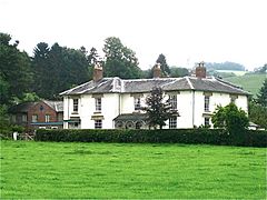
- Cefn Bryntalch: This large house was built between 1867 and 1869. It's an important early example of the Queen Anne revival style. The composer Peter Warlock lived here in the early 1900s. It is a very important historic building.
- Rectory: Built between 1812 and 1814, this building has a well-preserved Regency design. It is also a protected historic building.
- Former School (now the Village Hall): This building is across from the church and was built at the same time.
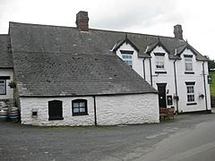
- Phipp's Tenement: This old farmhouse was built in 1630. It has strong timber framing.
- Oak House and Smithy: Built around 1700, this building was made from local stone. It might have been an inn and later became the village shop.

- The Upper House: This building was a pub before 1849.

- Brynderwen Bridge: Built in 1852, this bridge crosses the River Severn. It was designed by Thomas Penson. The parts for the bridge came from an ironworks and were brought by canal. It is a very important historic bridge.
- Fron Footbridge: This is a cool iron suspension footbridge over the Severn. It was built in 1926.

- Fronfraith Hall: Designed around 1860, the west wing of this hall burned down in 1966.
Playing Quoits
Quoits is a game where players throw metal rings at a target. It used to be very popular in many rural areas. In Llandyssil, they played by "old" or "long" quoits rules. The village had a special court for the game behind The Upper House pub.
In 1983, Wales played Scotland in an international match here and won! In 1991, Wales beat Scotland again by a big score. The last championship game was held in Llandyssil in 2003.
Sheep Dog Trials
In 2012, Llandyssil hosted the Welsh National Sheep Dog Trials. This is a competition where trained dogs show how well they can herd sheep. It took place near the bridge at Henfron from July 19th to 21st.
Famous People from Llandyssil
- Rear Admiral Sir Charles Thomas Jones (1778–1853): A Royal Navy officer.

- George Thomas (1786–1859): A writer and poet. He was the first postmaster of Llandyssil. He wrote a poem about otter hunting, which is shown in a painting at the National Museum of Wales.
- Peter Warlock (1894–1930): A famous composer who lived at Cefn Bryntalch. He wrote many of his pieces there and also played the organ in Llandyssil church.
.jpg)
- Diz Disley (1931–2010): A jazz guitarist who lived in Oak Cottages in the 1930s.
- Julie Christie (born 1940): A well-known actress who lived at Whitehall Farm from 1981 to 2010.
- Iolo Williams (born 1962): A naturalist and TV presenter who lives in Llandyssil.
Gallery
-
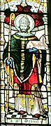
St Tyssul, Montgomery church
-
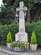
Llandyssil War Memorial
-
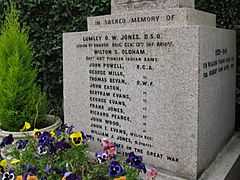
Llandyssil War Memorial - the 1914–18 War
-
Llandyssil Bridge
-
The Upper House, Public House, Llandyssil
-
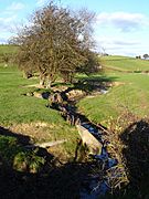
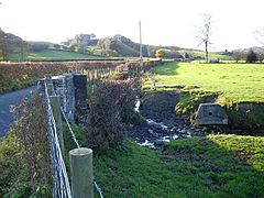
Brook from Llandyssil Bridge
-
Brooklyn, Llandyssil
-
The Old Rectory, Llandyssil
-
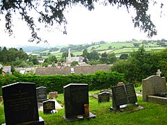
View over Llandyssil from the old churchyard.
-
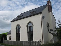
The Former Wesleyan Chapel, Llandyssil
-
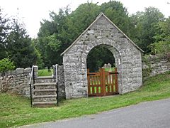
Lych Gate, St Tysul's Old churchyard, Llandyssil
-
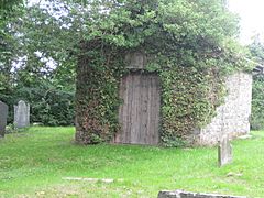
The re-built porch of the Old Church, Llandyssil
-
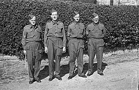
Llandyssil Home Guard after a Church Parade at Parish Church
-
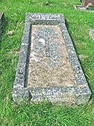
Llandyssil Churchyard. Grave of Walter Buckley Jones and wife Edith
-
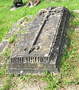
Llandyssil Churchyard. Grave of Richard Jones and wife Catharina.
-
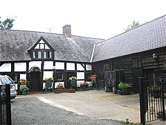
Phipp's Tenement and Barn, Llandyssil
-
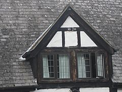
Dormer Window dated 1630, Phipp's Tenement, Llandyssil


.jpg)


