Lone Butte (British Columbia) facts for kids
- See Lone Butte for other mountains of this name.
Quick facts for kids Lone Butte |
|
|---|---|
 |
|
| Highest point | |
| Elevation | 1,237 m (4,058 ft) |
| Prominence | 58 m (190 ft) |
| Listing | List of volcanoes in Canada |
| Geography | |
| Location | South Cariboo, British Columbia, Canada |
| Parent range | Cariboo Plateau |
| Topo map | NTS 92P/11 |
| Geology | |
| Mountain type | Volcanic plug |
| Volcanic arc/belt | Chilcotin Group |
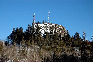
Lone Butte is a unique hill in southern British Columbia, Canada. It's like a giant natural pillar, also called a volcanic plug. This means it's the leftover core of an ancient volcano.
It formed about six million years ago from basalt rock. Lone Butte is part of the Chilcotin Group, a special area of old volcanoes. It sits on the Cariboo Plateau, between the Coast Mountains and the Fraser River. Today, Lone Butte is important for internet! BCWireless uses it as a main spot to send out broadband internet.
Where is Lone Butte?
Lone Butte is located about 13 kilometers (8 miles) southeast of 100 Mile House. It is just north of a fun lake community called Green Lake. The hill stands tall, rising more than 50 meters (164 feet) above the flat land around it.
It looks a lot like a butte, which is a tall, flat-topped hill. It's similar to the famous Devils Tower in Wyoming, USA. The small town of Lone Butte is found on the north side of this mountain. There are also two communication towers on the butte. BCWireless has one on the very top, and Navigata has one on its eastern side.

