Los Ranchos de Albuquerque, New Mexico facts for kids
Quick facts for kids
Los Ranchos de Albuquerque, New Mexico
|
|
|---|---|
|
Village
|
|

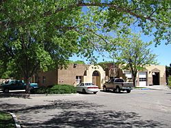
Village Hall
|
|

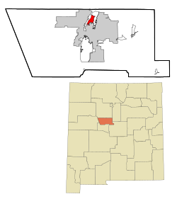
Location of Los Ranchos de Albuquerque, New Mexico
|
|
| Country | |
| State | |
| County | Bernalillo |
| Area | |
| • Total | 4.45 sq mi (11.53 km2) |
| • Land | 4.45 sq mi (11.53 km2) |
| • Water | 0.00 sq mi (0.00 km2) |
| Elevation | 4,984 ft (1,519 m) |
| Population
(2020)
|
|
| • Total | 5,874 |
| • Density | 1,319.41/sq mi (509.45/km2) |
| Time zone | UTC-7 (Mountain (MST)) |
| • Summer (DST) | UTC-6 (MDT) |
| ZIP codes |
87107, 87114
|
| Area code(s) | 505 |
| FIPS code | 35-43930 |
| GNIS feature ID | 2413568 |
Los Ranchos de Albuquerque, often called "Los Ranchos," is a small village in Bernalillo County, New Mexico. It is a quiet place with a rich history. In 2010, about 6,024 people lived there.
Contents
About Los Ranchos
Los Ranchos is part of the larger Albuquerque metropolitan area. It sits on the east side of the Rio Grande river. The village is next to the North Valley area. The big city of Albuquerque surrounds Los Ranchos on three sides.
Like the North Valley and Corrales, Los Ranchos is mostly a rural area. It has widely spaced large houses. There is also a lot of thick plant life.
History of the Village
Early Pueblo Tribes
People have lived in the middle Rio Grande valley for a very long time. Signs of human activity date back to 10,000 B.C. Around 1,000 B.C., maize (corn) came from Mexico. This changed how people lived.
Tribes that used to move around started to farm more. The first pueblos (villages) in the area appeared between 1 and 600 A.D. These were built by the Tiwas people. By 1,200 A.D., there were 14 major sites along the Rio Grande. The Chamisal Site in Los Ranchos was one of the largest.
In September 1540, Hernando de Alvarado was one of the first Europeans to see the region. He was part of an expedition led by Coronado. He described the area as a "broad valley planted with fields of maize." It also had many cottonwood trees. He noted "twelve pueblos, whose houses are built of mud and are two stories high."
First Settlers Arrive
The first group of Spanish settlers came to New Mexico in 1598. This group was led by Juan de Oñate. The fertile valley between Alameda and Atrisco slowly filled with settlers. They lived on scattered farms.
The settlers were forced out during the Pueblo Revolt of 1680. But they returned in 1692. Frequent attacks from Apache and Navajo tribes made settlers gather together. They built their homes into a series of plazas. These plazas were easier to defend.
Upriver from Albuquerque, these plazas included Los Duranes and Los Candelarias. They also included Los Griegos and Los Ranchos. The Los Ranchos plaza was likely built around 1750. In 1790, it had 176 residents in 40 homes. By 1814, the population grew to 331 people in 65 homes. The village even became the main town of Bernalillo County for a short time. This was from 1851 to 1854.
Unfortunately, the Los Ranchos area often flooded. Major floods in 1874 and 1891 badly damaged the old village. A third flood in 1904 completely destroyed it. The repeated flooding also made much of the land too salty to farm.
Growth in the 20th Century
After the railroad reached Albuquerque in 1880, many families sold their land. New settlers and land buyers came. There was a growing need for more homes. Small housing areas and large country estates started to appear. These were built along Rio Grande Boulevard. New roads were built, and old ones were paved or removed.
In the 20th century, a section of Guadalupe Trail became known as the new Los Ranchos. This half-mile stretch started south of Chamisal Road. It went north to Ranchitos Road.
The 1930s saw more Albuquerque families move to the North Valley. Some bought and fixed up old adobe homes. Others built large new houses. United States Representative Albert Simms and his wife Ruth Hanna McCormick were among these families. They built two houses designed by Santa Fe architect John Gaw Meem. These homes are now part of the Los Poblanos Ranch.
The valley continued to have many farms and ranches. Both Anglo and Spanish families ran dairies. After World War II, many new settlers came to Albuquerque. There were fewer people available to work the land. New housing developments began to appear on any open land in the Valley.
For example, Rob Lee Meadows was built where the old Los Ranchos plaza used to be. The farmlands of the Robert Dietz family became the Dietz Farms houses. Over 100 acres owned by the Charles Mann family became the Meadows on Rio Grande and Thomas Village homes.
Becoming an Official Village
After the war, many new people arrived. This sudden growth worried residents. They feared Albuquerque would take over Los Ranchos. So, they decided to become an official village. This would help prevent being taken over.
The residents voted, and the village of Los Ranchos de Albuquerque became official. This happened on December 29, 1958. People involved in this effort included William Kitsch, Frederick O'Hara, Sam Hartnett, Paul Gillespie, and Robert Nordhaus.
This area was the least developed part of the valley. It had many large homes and open spaces. Rules about lot size and how land could be used helped keep the area less built up. It remains greener than other parts of the North Valley.
Today, Los Ranchos has kept much of its original rural and farming feel. It is one of the most desired places to live in the Albuquerque area.
Geography
Los Ranchos de Albuquerque covers about 11.3 square kilometers (4.4 square miles). All of this area is land.
Population Information
| Historical population | |||
|---|---|---|---|
| Census | Pop. | %± | |
| 1880 | 400 | — | |
| 1970 | 1,900 | — | |
| 1980 | 2,741 | 44.3% | |
| 1990 | 3,955 | 44.3% | |
| 2000 | 5,092 | 28.7% | |
| 2010 | 6,024 | 18.3% | |
| 2020 | 5,874 | −2.5% | |
| U.S. Decennial Census | |||
In 2000, there were 5,092 people living in the village. There were 1,997 households and 1,431 families. The population density was about 1,247 people per square mile. There were 2,107 housing units.
Most residents were White (81.60%). About 37.41% of the population identified as Hispanic or Latino.
About 30.1% of households had children under 18 living with them. Most households (57.4%) were married couples. The average household had 2.55 people. The average family had 2.98 people.
The population was spread out by age. About 23.9% were under 18 years old. The median age was 43 years. This means half the people were older than 43, and half were younger.
In 2000, the median income for a household was $60,500. For a family, it was $77,150. The average income per person was $40,883. About 8.7% of the total population lived below the poverty line. This included 11.6% of those under 18.
Notable People
- Joshua Cooper Ramo, an author and consultant.
- John Ryan, a former member of the New Mexico House of Representatives.
- José Sarria, an activist.
- Roy Tackett, an author and co-founder of Bubonicon.
Education
Students in Los Ranchos attend schools that are part of Albuquerque Public Schools.
See also
 In Spanish: Los Ranchos de Albuquerque para niños
 | Delilah Pierce |
 | Gordon Parks |
 | Augusta Savage |
 | Charles Ethan Porter |


