
Lott, Texas facts for kids
Quick facts for kids
Lott, Texas
|
|
|---|---|
.jpg)
Downtown Lott
|
|

Location within Falls County and Texas
|
|
| Country | |
| State | |
| County | Falls |
| Area | |
| • Total | 1.02 sq mi (2.65 km2) |
| • Land | 1.01 sq mi (2.62 km2) |
| • Water | 0.01 sq mi (0.04 km2) |
| Elevation | 535 ft (163 m) |
| Population
(2020)
|
|
| • Total | 644 |
| • Density | 734.65/sq mi (283.60/km2) |
| Time zone | UTC-6 (Central (CST)) |
| • Summer (DST) | UTC-5 (CDT) |
| ZIP code |
76656
|
| Area code | 254 |
| FIPS code | 48-44176 |
| GNIS feature ID | 2410883 |
Lott is a small city located in Falls County, Texas, in the United States. In 2020, about 644 people lived here. It's a place with an interesting history and a unique way of raising money for the town.

Contents
History of Lott, Texas
Lott began in 1889 when the Texas Townsite Company bought land. The city was officially founded in 1890. This happened when the San Antonio and Aransas Pass Railway built its tracks through the area. The town was named after Uriah Lott, who was the president of the railroad company.
Early Growth and Development
A post office opened in Lott in 1890. Later that year, the community voted to become an official city. At that time, more than 200 people lived there. By 1892, Lott had three churches: Baptist, Methodist, and Presbyterian. It also had businesses that processed cotton and grain. A weekly newspaper was published, and the population grew to 350 residents.
By the late 1890s, Lott's population was estimated to be as high as 1,200 people. The town continued to grow in the early 1900s. Two banks, the First National Bank of Lott and the Lott State Bank, opened in 1903 and 1909. Local businesses were doing well, and people were hopeful about the city's future.
Changes and Challenges
In the 1920s, Lott's economy got another boost. This happened when State Highway 44 (which later became U.S. 77) was built through the community. However, the Great Depression in the 1930s brought big changes. The First National Bank of Lott closed in 1933. Many families needed government help to get by. Some residents found jobs through government programs that built streets and water systems.
Farmers in the area used to grow mostly cotton and corn. But government programs encouraged them to try new things. They started raising livestock and growing different kinds of vegetables. The population of Lott changed over the years. It was 921 in the 1930s, grew to 1,021 in the 1940s, but then dropped to 956 by the early 1950s.
Lott lost its train service in 1967. This happened when the Southern Pacific railroad stopped using the tracks nearby. From the 1960s to the 1980s, Lott's population stayed between 750 and 950 people. The number of businesses also went down during this time.
Lott's Unique Revenue Source
Lott became known as a "speed trap" town. This means that the local police often give out speeding tickets. This practice helps the city earn money for its services. In 2015, a TV station reported on this. They said that Lott, along with other Texas cities, used their police departments to issue many speeding tickets. This helped their city courts bring in money.
Geography of Lott
Lott is located in the southwestern part of Falls County. It sits on high ground between two creeks. Little Deer Creek flows north, and Cottonwood Creek flows south. Both of these creeks eventually flow into the Brazos River.
Major Roads and Highways
U.S. Route 77 goes right through the city of Lott. If you drive north on US 77, you will reach Waco in about 26 miles (42 km). If you drive south, you will get to Cameron in about 25 miles (40 km).
Texas State Highway 320 also crosses US 77 on the west side of downtown Lott. This highway leads northeast about 11 miles (18 km) to Marlin. If you go southwest on Highway 320, you will reach Zabcikville in about 14 miles (23 km).
Area and Water
According to the United States Census Bureau, the city of Lott covers a total area of about 2.7 square kilometers (1.02 sq mi). A small part of this area, about 0.04 square kilometers (0.01 sq mi), is water. This means that about 1.40% of Lott's total area is covered by water.
Population and People
The population of Lott has changed over the years. Here is a look at how many people have lived in Lott during different census years:
| Historical population | |||
|---|---|---|---|
| Census | Pop. | %± | |
| 1900 | 614 | — | |
| 1910 | 1,021 | 66.3% | |
| 1920 | 1,093 | 7.1% | |
| 1930 | 921 | −15.7% | |
| 1940 | 1,021 | 10.9% | |
| 1950 | 956 | −6.4% | |
| 1960 | 924 | −3.3% | |
| 1970 | 799 | −13.5% | |
| 1980 | 865 | 8.3% | |
| 1990 | 775 | −10.4% | |
| 2000 | 724 | −6.6% | |
| 2010 | 759 | 4.8% | |
| 2020 | 644 | −15.2% | |
| U.S. Decennial Census | |||
Lott's Diverse Community
Lott is home to people from different backgrounds. The table below shows the racial makeup of Lott as of the 2020 United States census. NH means "Non-Hispanic."
| Race | Number | Percentage |
|---|---|---|
| White (NH) | 383 | 59.47% |
| Black or African American (NH) | 105 | 16.3% |
| Native American or Alaska Native (NH) | 4 | 0.62% |
| Asian (NH) | 1 | 0.16% |
| Some Other Race (NH) | 3 | 0.47% |
| Mixed/Multi-Racial (NH) | 26 | 4.04% |
| Hispanic or Latino | 122 | 18.94% |
| Total | 644 |
In 2020, there were 644 people living in Lott. These people lived in 243 households, and 139 of these were families.
In the year 2000, there were 724 people in Lott. They lived in 299 households, and 196 of these were families. About 33.8% of households had children under 18. The average household had 2.42 people. The average family had 3.07 people.
The population in 2000 was spread out by age. About 29.0% were under 18. About 17.4% were 65 years old or older. The average age in the city was 37 years.
Education in Lott
The schools in Lott are part of the Rosebud-Lott Independent School District. This district serves the students living in the city of Lott.
Photo gallery
-
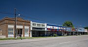
Downtown Lott, Texas
-
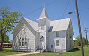
United Methodist Church
.jpg)
.jpg)
See also
 In Spanish: Lott (Texas) para niños
