Falls County, Texas facts for kids
Quick facts for kids
Falls County
|
||
|---|---|---|

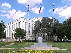
The Falls County Courthouse in Marlin. The courthouse was added to the National Register of Historic Places on December 13, 2000.
|
||
|
||

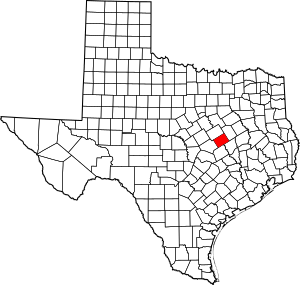
Location within the U.S. state of Texas
|
||
 Texas's location within the U.S. |
||
| Country | ||
| State | ||
| Founded | 1850 | |
| Named for | Falls on the Brazos Park | |
| Seat | Marlin | |
| Largest city | Marlin | |
| Area | ||
| • Total | 774 sq mi (2,000 km2) | |
| • Land | 765 sq mi (1,980 km2) | |
| • Water | 8.4 sq mi (22 km2) 1.1% | |
| Population
(2020)
|
||
| • Total | 16,968 | |
| • Density | 21.922/sq mi (8.464/km2) | |
| Time zone | UTC−6 (Central) | |
| • Summer (DST) | UTC−5 (CDT) | |
| Congressional district | 17th | |
Falls County is a special area of land in the state of Texas, USA. It's called a county. In 2020, about 16,968 people lived here. The main town and government center is Marlin.
The county got its name from a 10-foot-tall waterfall on the Brazos River. This waterfall was a big landmark until a storm in 1866 changed the river's path. Today, you can find a smaller waterfall about two miles northeast of the original spot. This area is now called Falls on the Brazos Park, a nice place for camping near Marlin.
Falls County is also part of the larger Waco area. A big part of the county's economy comes from farming. Falls County is actually one of the top counties in Texas for growing corn!
Contents
History
First People
Long ago, the Brazos River valley was a hunting ground for several Native American tribes. These included the Wacos, Tawakonis, and Anadarkos. The Comanches were also in the area and sometimes pushed other tribes away.
The Tawakoni tribe, a branch of the Wichita Indians, moved south into East Texas. They made agreements with both the Republic of Texas and the United States government starting in 1843.
The Cherokees arrived in the early 1830s. A famous Texan, Sam Houston, who was like an adopted son to a Cherokee chief, helped make a peace agreement in 1836.
In 1839, there were some conflicts between settlers and the Anadarko tribe in Falls County. Later, in 1846, several tribes signed a peace treaty with the United States government.
Early Settlers
In the early 1800s, people like Sterling C. Robertson and Robert Leftwich were given permission to bring families to settle in this part of Texas. This was a way for the government to control how new towns were built. Robertson brought American settlers, mostly from Alabama, Tennessee, and Mississippi, to his Nashville colony.
A fort called Fort Viesca was built in 1834. It was later renamed Fort Milam. During a time called the Runaway Scrape in 1836, settlers left the area for safety. But they came back after the important Battle of San Jacinto.
County is Formed
Falls County was officially created in 1850 by the state government. It was formed from parts of Limestone and Milam Counties. As you know, it was named after the Brazos River falls. Marlin became the county seat, which is where the county government is located.
Before the American Civil War, in 1860, there were 1,716 enslaved people in the county. Falls County chose to join the Confederacy during the war. After the war, during the Reconstruction period, Falls County did better than some other areas because it was farther away from where Union soldiers were stationed.
In the 1890s, Marlin became famous for its hot mineral waters, which people believed had healing powers. A well-known hotel builder, Conrad Hilton, even built the Falls Hotel there. It had a special tunnel leading to a mineral bath!
Railroads also came to Falls County, making it easier to travel and move goods. The first railroad arrived around 1870. More railroads followed, connecting the county to other parts of Texas.
The county's first courthouse in the 1850s was a simple log cabin. Later, a second courthouse was built, but it burned down in 1870. A third one was built in 1876, but it was damaged by a storm. The fourth courthouse was built in 1888. The fifth and current courthouse, which you can see today, was finished in 1939. It's a strong building made of concrete, brick, and stone.
Geography
Falls County covers about 774 square miles. Most of this area, about 765 square miles, is land. The rest, about 8.4 square miles, is covered by water.
Main Roads
You can find several important roads in Falls County:
 Interstate 35 (a very small part)
 U.S. Highway 77
 State Highway 6
 State Highway 7
 State Highway 14
 State Highway 53
 State Highway 320
Neighboring Counties
Falls County shares its borders with these other counties:
- Limestone County (to the northeast)
- Robertson County (to the southeast)
- Milam County (to the south)
- Bell County (to the southwest)
- McLennan County (to the northwest)
Population
The number of people living in Falls County has changed over the years.
| Historical population | |||
|---|---|---|---|
| Census | Pop. | %± | |
| 1860 | 3,614 | — | |
| 1870 | 9,851 | 172.6% | |
| 1880 | 16,240 | 64.9% | |
| 1890 | 20,706 | 27.5% | |
| 1900 | 33,342 | 61.0% | |
| 1910 | 35,649 | 6.9% | |
| 1920 | 36,217 | 1.6% | |
| 1930 | 38,771 | 7.1% | |
| 1940 | 35,984 | −7.2% | |
| 1950 | 26,724 | −25.7% | |
| 1960 | 21,263 | −20.4% | |
| 1970 | 17,300 | −18.6% | |
| 1980 | 17,946 | 3.7% | |
| 1990 | 17,712 | −1.3% | |
| 2000 | 18,576 | 4.9% | |
| 2010 | 17,866 | −3.8% | |
| 2020 | 16,968 | −5.0% | |
| U.S. Decennial Census 1850–2010 2010 2020 |
|||
In 2020, the population of Falls County was 16,968 people. This number has changed over time, with the highest population recorded in 1930.
Communities
Cities and towns
- Bruceville-Eddy (mostly in McLennan County)
- Golinda (small part in McLennan County)
- Lott
- Marlin (county seat)
- Rosebud
Census-designated place
Unincorporated communities
See also
 In Spanish: Condado de Falls para niños
 | Roy Wilkins |
 | John Lewis |
 | Linda Carol Brown |


