Limestone County, Texas facts for kids
Quick facts for kids
Limestone County
|
|
|---|---|

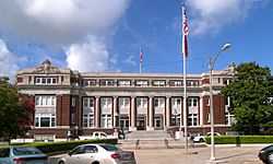
The Limestone County Courthouse in Groesbeck
|
|

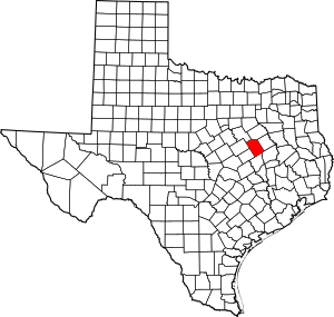
Location within the U.S. state of Texas
|
|
 Texas's location within the U.S. |
|
| Country | |
| State | |
| Founded | 1846 |
| Seat | Groesbeck |
| Largest city | Mexia |
| Area | |
| • Total | 933 sq mi (2,420 km2) |
| • Land | 905 sq mi (2,340 km2) |
| • Water | 28 sq mi (70 km2) 3.0% |
| Population
(2020)
|
|
| • Total | 22,146 |
| • Density | 23.736/sq mi (9.165/km2) |
| Time zone | UTC−6 (Central) |
| • Summer (DST) | UTC−5 (CDT) |
| Congressional district | 17th |
Limestone County is a special area in Texas, a state in the United States. It's like a big neighborhood with its own local government. In 2020, about 22,146 people lived here. The main town and center of the county's government is Groesbeck. Limestone County was officially created in 1846.
Contents
History of Limestone County
Native American Tribes
Long ago, different Native American tribes lived in East Texas. Some were friendly with the early settlers. Tribes like the Kiowa, Apache, and Comanche later moved into these areas. These tribes were skilled hunters and farmers. They also traded goods with others.
The Tawakoni people were a branch of the Wichita Indians. They originally lived north of Texas but later moved south. From 1843, the Tawakoni were part of important agreements with both the Republic of Texas and the United States. The town of Tehuacana in Limestone County is named after a former Tawakoni village. The Waco people were also part of the Wichita tribes.
Fort Parker Attack
A well-known event in Texas history happened in Limestone County on May 19, 1836. A group of Comanche, Kiowa, Caddo, and Wichita warriors approached Fort Parker. They pretended to be peaceful. However, they then attacked the fort. Many settlers were killed or taken captive. Only about 18 people managed to escape.
Among those captured were Elizabeth Kellogg, Rachel Plummer and her son James, and John Richard Parker with his sister Cynthia Parker. Cynthia Ann Parker later became the mother of the famous Comanche Chief Quanah Parker.
Early Settlers
Limestone County was part of large land grants given by the government in 1825. These grants allowed people like Haden Harrison Edwards and Robertson to bring families to settle the land. The government wanted to control how new communities were formed.
A religious leader named Daniel Parker and eight other men started a church in Illinois. In 1833, their entire group moved to the new frontier of Texas. Among these settlers were Silas M. Parker, Moses Herrin, and others. Fort Parker was the first real settlement in the area. After these first settlers, more communities began to grow.
County Formation
Limestone County was officially formed on April 11, 1846. It was created from a larger area called Robertson County. On August 18, 1846, the county government was set up. The first county seat, or main town, was Springfield.
In 1873, the county seat was moved to Groesbeck. This happened after the county's borders changed and the courthouse in Springfield burned down. Early settlers were mostly farmers and ranchers. They also hunted wild animals for food. Businesses grew to support farming and ranching. By 1860, the county had 4,537 people. This included 3,464 white settlers and 1,072 enslaved people.
Civil War and Reconstruction
When the American Civil War began, Limestone County strongly supported leaving the Union. They voted 525 to 9 in favor of secession. Many men from the county went to fight for the Confederate States of America.
After the war, during the Reconstruction period, there were many problems in the county. There was violence and threats against the government. Because of this, in October 1871, Texas Governor Edmund J. Davis declared martial law. This meant the military took control to keep order.
Growth After the Civil War
After the Civil War, new developments helped Limestone County grow. In 1869, the Houston and Texas Central Railway built train tracks. These tracks ended near Kosse, a town named after the railway's chief engineer. Later, in 1903, the Trinity and Brazos Valley Railway built more tracks. Several new towns grew up along these railway lines.
The Thornton Institute was a school founded in 1877. It was officially recognized in 1881 as the Thornton Male and Female Institute. This school offered dormitories for students. Many of its graduates went on to become teachers in rural Texas. The school was later given to the Thornton Independent School District in 1891.
Between 1913 and 1920, oil and gas were found in Mexia. This discovery created many jobs and caused a huge population boom. The town's population jumped from 3,482 to 35,000 by 1922! For a short time, martial law had to be declared in Mexia due to the rapid growth.
During the Great Depression, the population started to decrease. To help the economy, programs like the Work Projects Administration (WPA) and the Civilian Conservation Corps (CCC) were created. The CCC built Fort Parker State Recreation Area. The WPA built many buildings in the county. During World War II, a German prisoner of war camp called Camp Mexia was built here.
Geography of Limestone County
Limestone County covers a total area of 933 square miles. Most of this area, 905 square miles, is land. The remaining 28 square miles, which is about 3% of the total area, is covered by water.
Main Highways
Neighboring Counties
Limestone County shares its borders with several other counties:
- Navarro County (to the north)
- Freestone County (to the northeast)
- Leon County (to the southeast)
- Robertson County (to the south)
- Falls County (to the southwest)
- McLennan County (to the west)
- Hill County (to the northwest)
Population Information
| Historical population | |||
|---|---|---|---|
| Census | Pop. | %± | |
| 1850 | 2,608 | — | |
| 1860 | 4,537 | 74.0% | |
| 1870 | 8,591 | 89.4% | |
| 1880 | 16,246 | 89.1% | |
| 1890 | 21,678 | 33.4% | |
| 1900 | 32,573 | 50.3% | |
| 1910 | 34,621 | 6.3% | |
| 1920 | 33,283 | −3.9% | |
| 1930 | 39,497 | 18.7% | |
| 1940 | 33,781 | −14.5% | |
| 1950 | 25,251 | −25.3% | |
| 1960 | 20,413 | −19.2% | |
| 1970 | 18,100 | −11.3% | |
| 1980 | 20,224 | 11.7% | |
| 1990 | 20,946 | 3.6% | |
| 2000 | 22,051 | 5.3% | |
| 2010 | 23,384 | 6.0% | |
| 2020 | 22,146 | −5.3% | |
| U.S. Decennial Census 1850–2010 2010 2020 |
|||
In 2020, the population of Limestone County was 22,146 people. The population has changed a lot over the years. For example, in 1850, there were only 2,608 people. The population grew steadily until the 1930s, reaching almost 40,000 people. After that, it decreased for a while before starting to grow again.
Towns and Communities
Cities
- Groesbeck (This is the county seat, where the main government offices are.)
- Mart (Most of this city is in McLennan County.)
- Mexia
Towns
Small Communities
- Ben Hur
- Big Hill
- Box Church
- Buffalo Mop
- Forest Glade
- Old Union
- Oletha
- Prairie Hill
- Victoria
Former Town
- Springfield (This was once a town but is now a ghost town.)
Famous People from Limestone County
- Sheppard Mullins (19th-century), an African American state legislator.
- Alfonso Steele (1817–1911) was born in Kentucky and is buried in Mexia.
- Anna Nicole Smith (1967–2007) lived in Mexia for a short time.
- Don the Beachcomber (1907–1989) was born Ernest Raymond Beaumont Gantt in Limestone County. He was famous for his tiki-themed restaurants.
- Bob Wills (1905-1975) was born on a farm in Kosse. He was a very important musician in country music, known as the "King of Western Swing."
- Rachel Plummer (1819-1839) was captured by Comanches when she was seventeen. She later wrote about her difficult experience before she passed away.
Education in Limestone County
Several school districts serve the students in Limestone County:
- Axtell Independent School District
- Coolidge Independent School District
- Groesbeck Independent School District
- Hubbard Independent School District
- Mart Independent School District
- Mexia Independent School District
- Mount Calm Independent School District
- Wortham Independent School District
The entire county is also part of the service area for Navarro College. This means students in Limestone County can attend this college.
See also
 In Spanish: Condado de Limestone (Texas) para niños
 | George Robert Carruthers |
 | Patricia Bath |
 | Jan Ernst Matzeliger |
 | Alexander Miles |

