Lovettsville, Virginia facts for kids
Quick facts for kids
Lovettsville, Virginia
|
||
|---|---|---|
| Town of Lovettsville | ||

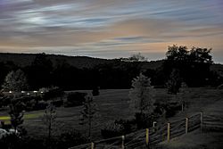
Lovettsville in September 2008
|
||
|
||
| Country | ||
| State | ||
| County | Loudoun | |
| Area | ||
| • Total | 0.85 sq mi (2.20 km2) | |
| • Land | 0.84 sq mi (2.19 km2) | |
| • Water | 0.00 sq mi (0.01 km2) | |
| Elevation | 505 ft (154 m) | |
| Population
(2010)
|
||
| • Total | 1,613 | |
| • Estimate
(2019)
|
2,198 | |
| • Density | 2,604.27/sq mi (1,005.09/km2) | |
| Time zone | UTC-5 (Eastern (EST)) | |
| • Summer (DST) | UTC-4 (EDT) | |
| ZIP code |
20180
|
|
| Area code(s) | 540 | |
| FIPS code | 51-47208 | |
| GNIS feature ID | 1495879 | |
Lovettsville is a town in Loudoun County, Virginia, in the United States. It is located near the northern tip of the state. Many German immigrants first settled the area. The town was officially started in 1836.
In 2010, about 1,613 people lived there. By 2019, the population was estimated to be around 2,198.
Contents
History of Lovettsville
Early Settlement and Naming
After a treaty in 1722, German immigrants began moving to the northern Loudoun Valley. They came to farm the rich soil. They built several small villages, often using logs and wood. One of these villages was called "The German Settlement."
In 1820, a man named David Lovett divided his land into small "city lots." This led to a lot of building, and the town was then called "Newtown." In 1828, the town was renamed "Lovettsville." The state of Virginia officially recognized Lovettsville as a town in 1836. However, it wasn't fully set up as a town until 1876.
Lovettsville During the Civil War
During the American Civil War, Lovettsville was an important stop for Union soldiers. They used the town when crossing the Potomac River. Lovettsville was one of the few places in Loudoun County that voted against leaving the United States.
Notable Events in Lovettsville's Past
In 1940, a DC-3 airplane crashed near Lovettsville. This was the worst plane crash in US history at that time. It killed 25 people, including a US Senator. This event is known as the Lovettsville air disaster.
The Lovettsville Historic District was added to the National Register of Historic Places in 2012. This means it's a special area with important old buildings.
In 2018, something fun happened! The town council voted to temporarily rename Lovettsville "Capitals-ville." This was to support the NHL's Washington Capitals hockey team. They had made it to the Stanley Cup Finals that year.
Geography of Lovettsville
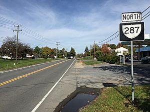
Lovettsville is located in northern Loudoun County. It sits at coordinates 39°16.4′N 77°38.4′W / 39.2733°N 77.6400°W. Virginia State Route 287 runs through the middle of town. This road goes north about 3 miles to Brunswick, Maryland. It also goes south about 11 miles to Purcellville. Leesburg, the main town of Loudoun County, is about 14 miles southeast.
The town covers about 0.85 square miles (2.2 square kilometers). A very small part of this area is water. Lovettsville is on a low ridge in the Loudoun Valley. Water on the west side of town flows into Dutchman Creek. Water on the east side flows into Quarter Branch. Both of these streams eventually flow north to the Potomac River.
Population and People
| Historical population | |||
|---|---|---|---|
| Census | Pop. | %± | |
| 1870 | 155 | — | |
| 1880 | 92 | −40.6% | |
| 1900 | 97 | — | |
| 1910 | 192 | 97.9% | |
| 1920 | 167 | −13.0% | |
| 1930 | 239 | 43.1% | |
| 1940 | 248 | 3.8% | |
| 1950 | 341 | 37.5% | |
| 1960 | 217 | −36.4% | |
| 1970 | 185 | −14.7% | |
| 1980 | 613 | 231.4% | |
| 1990 | 749 | 22.2% | |
| 2000 | 853 | 13.9% | |
| 2010 | 1,613 | 89.1% | |
| 2019 (est.) | 2,198 | 36.3% | |
| U.S. Decennial Census | |||
In 2010, the town had 1,613 people living in 566 households. About 424 of these were families. The population density was about 1,833 people per square mile.
Many households, about 46.6%, had children under 18 living with them. Most households, 59.4%, were married couples. About 11.1% were female householders without a husband. The average household had 2.85 people.
The population was spread out by age. About 32.4% were under 18 years old. About 33.4% were between 25 and 44 years old. The median age in the town was 33.5 years.
Transportation
The main road serving Lovettsville is Virginia State Route 287. This road goes south to Virginia State Route 7 in Purcellville. It also goes north to the Potomac River. A bridge there connects SR 287 to Brunswick, Maryland.
Town Events
Lovettsville hosts several fun events throughout the year:
- Lovettsville Oktoberfest: This event usually happens on the last full weekend of September. It celebrates German culture.
- Mayfest: Held over Memorial Day Weekend, this is Lovettsville's "All-American town picnic."
- Christkindlmarkt: In early December, the Loudoun Valley German Society hosts this traditional German Christmas market.
- Bezerkle on the Squirkle: On New Year's Day, people can join this 5K fun run. It goes around the unique traffic square in the center of town.
- Movies and Concerts on the Green: During warmer months, the town hosts movies and concerts at the Walker Pavilion.
Notable People from Lovettsville
- Warren T. Brookes: A newspaper columnist.
- Hal Douglas: A famous voiceover artist.
- Rob Jones: A United States Marine.
- Chip Roy: A U.S. Representative from Texas, who grew up in Lovettsville.
See also
 In Spanish: Lovettsville (Virginia) para niños
 | John T. Biggers |
 | Thomas Blackshear |
 | Mark Bradford |
 | Beverly Buchanan |


