Lovewell Reservoir facts for kids
Quick facts for kids Lovewell Reservoir |
|
|---|---|
| Location | Jewell County, Kansas |
| Coordinates | 39°53′52″N 98°03′51″W / 39.89778°N 98.06417°W |
| Type | Reservoir |
| Primary inflows | White Rock Creek |
| Primary outflows | White Rock Creek |
| Catchment area | 358 sq mi (930 km2) |
| Basin countries | United States |
| Managing agency | U.S. Bureau of Reclamation |
| Built | January 27, 1955 |
| First flooded | October 1, 1957 |
| Max. length | 11 miles (18 km) |
| Surface area | 2,987 acres (12.09 km2) |
| Max. depth | 35 feet (11 m) |
| Water volume | Full: 35,666 acre⋅ft (43,993,000 m3) Current (Nov. 2015): 30,371 acre⋅ft (37,462,000 m3) |
| Shore length1 | 44 miles (71 km) |
| Surface elevation | Full: 1,583 ft (482 m) Current (Nov. 2015): 1,581 ft (482 m) |
| Settlements | Webber |
| 1 Shore length is not a well-defined measure. | |
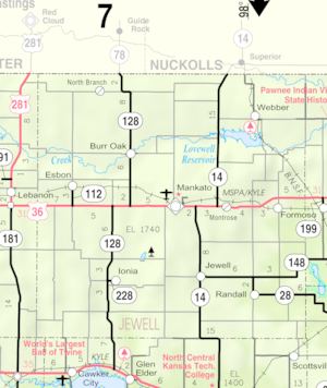
Lovewell Reservoir is a large lake in Jewell County, Kansas. It was built and is managed by the U.S. Bureau of Reclamation. This reservoir helps control floods, provides water for farms, and is a fun place for outdoor activities. You can find Lovewell State Park right on its north side!

Contents
History of Lovewell Reservoir
Why Was Lovewell Reservoir Built?
In 1935, a huge flood on the Republican River caused a lot of damage. This made leaders from Colorado, Kansas, and Nebraska ask for a plan to control floods and help farmers get water. Both the U.S. Army Corps of Engineers and the U.S. Bureau of Reclamation studied the idea.
Their studies led to a big project called the Bostwick Division. This project was approved by the Flood Control Act of 1944. It was part of an even larger plan called the Pick-Sloan Missouri Basin Program.
Building the Dam and Reservoir
The Bostwick Division project included building Lovewell Dam and Lovewell Reservoir. The reservoir was named after Thomas Lovewell, an early settler in Jewell County, Kansas. It was built on White Rock Creek, which flows into the Republican River.
Construction of the dam started on January 27, 1955. The dam was finished in 1957. The reservoir began filling with water on October 1, 1957, and was ready for use by October 15, 1957.
Where is Lovewell Reservoir?
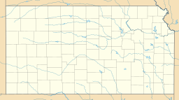
Lovewell Reservoir is located in the very northern part of central Kansas. It sits in the Smoky Hills region, which is part of the larger Great Plains. The entire reservoir is within Jewell County, Kansas.
Lovewell Dam and Water Flow
The reservoir is held back by Lovewell Dam at its eastern end. The dam is a big earth wall that keeps the water in. White Rock Creek is the main stream that flows into the reservoir from the west. It also flows out of the reservoir to the east. Other smaller streams, like Montana Creek and Johns Creek, also flow into the reservoir.
Roads and Nearby Towns
Kansas Highway 14 runs north and south just west of the reservoir. North Shore Road, a paved county road, runs east and west along the north side of the reservoir.
The small town of Webber, Kansas is about 2 miles (3.2 km) north of the reservoir's east end.
How Big is Lovewell Reservoir?
The size of the reservoir changes depending on how much water flows in and the weather. The U.S. Bureau of Reclamation divides the reservoir into different sections based on water levels.
When Lovewell Reservoir is full, it covers about 2,987 acres (12.09 km2) of land. The water level is then about 1,583 feet (482 m) high. At this level, it holds about 35,666 acre-feet (43,993,000 m3) of water.
If the reservoir fills to its maximum possible capacity, it can cover up to 7,635 acres (30.90 km2). The water level would then be about 1,610 feet (490 m) high.
How Lovewell Dam Works
Lovewell Dam is an earth-fill dam. This means it's made mostly of packed earth. It stands about 93 feet (28 m) tall and stretches for about 8,500 feet (2,600 m).
At the south end of the dam, there's a concrete spillway. This is like a big drain with gates that can be opened to let water out into the creek. There's also a separate outlet nearby that can release water into a short canal.
Lovewell Reservoir is part of a larger system of canals and other reservoirs. These help provide water for farming across north-central Kansas and south-central Nebraska. A special gate from the Courtland Canal can also bring water into Lovewell Reservoir.
Who Manages Lovewell Reservoir?
The U.S. Bureau of Reclamation is in charge of operating and maintaining Lovewell Dam and Reservoir. The Kansas Department of Wildlife, Parks and Tourism (KDWP) manages the land around the reservoir. This area is known as the Lovewell Wildlife Area.
Fun Things to Do at Lovewell Reservoir
Lovewell State Park
The KDWP runs Lovewell State Park on the north shore of the reservoir. This park is a great place for outdoor fun! It has:
- Boat ramps for launching boats
- Camping spots for overnight stays
- Hiking trails for exploring nature
- A marina for boats
- Sports facilities
- A swimming beach
The park also hosts special events, holiday celebrations, and fishing tournaments throughout the year.
Fishing and Hunting
Lovewell Reservoir is a popular spot for sport fishing. You can try to catch different kinds of fish here. The Lovewell Wildlife Area is also open for hunting, but some areas might have restrictions.
Wildlife at Lovewell Reservoir
Fish Species
Many types of fish live in Lovewell Reservoir, including:
- Channel catfish
- Crappie
- Walleye
- Wiper
Other Animals
Around the reservoir, you might see various game animals like:
 | Madam C. J. Walker |
 | Janet Emerson Bashen |
 | Annie Turnbo Malone |
 | Maggie L. Walker |


