Lowther Hill facts for kids
Quick facts for kids Lowther Hill |
|
|---|---|
 |
|
| Highest point | |
| Elevation | 725 m (2,379 ft) |
| Prominence | 37 m (121 ft) |
| Listing | Tu,Sim, D,GT,DN |
| Geography | |
| Location | South Lanarkshire, Dumfries and Galloway, Scotland |
| Parent range | Lowther Hills, Southern Uplands |
| OS grid | NS 89056 10757 |
| Topo map | OS Landranger 71, 78 |
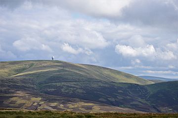
Lowther Hill is a cool mountain in the Lowther Hills range. This range is part of the Southern Uplands in Scotland. Even though the whole mountain range is named after it, Lowther Hill is actually the second highest peak in the Lowther Hills! It sits right on the border between Lanarkshire and Dumfries and Galloway. The mountain is found just east of the town of Sanquhar. Its very top part is located just inside Lanarkshire.
Contents
Exploring Lowther Hill
Lowther Hill is easy to spot from far away. You can see it from almost any direction if you are high up in the central Southern Uplands. This is partly because of a special building on its summit.
The "Golf Ball" on Top
The very top of Lowther Hill has a radar station. This station is owned by NATS. The big, round dome on top of the station looks like a giant golf ball. Because of its shape, people often call it "the golf ball." This radar helps to guide airplanes safely.
Getting to the Top
You can reach the radar station using a private road. This road starts in Wanlockhead. Wanlockhead is known as the highest village in Scotland. Even though cars are usually not allowed on this road, it is very popular. Many hillwalkers and cyclists love to use it. It offers an easy way to get to the top of the hill. People also use it just for fun and exercise.
Scotland's Highest Paved Road
If you keep going past Lowther Hill, you can reach Green Lowther. Green Lowther is the highest mountain in the range. The road connecting these two peaks is special. It is the second highest paved road in all of Britain. It is also the highest paved road in Scotland.
Part of the Southern Upland Way
Lowther Hill is also a big part of a famous walking trail. This trail is called the Southern Upland Way. It is a very long path, stretching for 344 kilometers (about 214 miles). The trail passes very close to the summit of Lowther Hill. It goes by at about 710 meters (2,329 feet) high. This makes Lowther Hill the highest point along the entire Southern Upland Way.
 | Ernest Everett Just |
 | Mary Jackson |
 | Emmett Chappelle |
 | Marie Maynard Daly |

