Loyalton, California facts for kids
Quick facts for kids
City of Loyalton
|
|
|---|---|

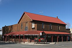
Sierra Valley Home Center in Loyalton
|
|

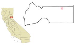
Location in Sierra County and the state of California
|
|
| Country | |
| State | |
| County | Sierra |
| Incorporated | August 21, 1901 |
| Government | |
| • Type | Council–manager |
| Area | |
| • Total | 0.35 sq mi (0.92 km2) |
| • Land | 0.35 sq mi (0.92 km2) |
| • Water | 0.00 sq mi (0.00 km2) 0% |
| Elevation | 4,951 ft (1,509 m) |
| Population
(2020)
|
|
| • Total | 740 |
| • Estimate
(2019)
|
702 |
| • Density | 2,114.3/sq mi (804.3/km2) |
| Time zone | UTC-8 (Pacific (PST)) |
| • Summer (DST) | UTC-7 (PDT) |
| ZIP code |
96118
|
| Area code(s) | 530 |
| FIPS code | 06-44364 |
| GNIS feature ID | 0277550 |
Loyalton is a small city in Sierra County, California, United States. In 2020, about 740 people lived there. This was a small decrease from the 769 people counted in 2010. The city's ZIP code is 96118. Loyalton is located near the end of State Route 49. This road is known as the Gold Country Highway. Many people in Loyalton work as ranchers or loggers. Some have moved there from bigger cities like the San Francisco Bay Area or Reno–Tahoe area.
Contents
History of Loyalton
Loyalton started as a settlement called "Smith's Neck." During the American Civil War, its name was changed to Loyalton. This new name showed that the people in the area supported the Union side.
The first people to settle here were mostly immigrants from Switzerland and Italy. They began setting up farms in the Sierra Valley in the late 1850s. Sawmills were also built to cut down trees from the nearby mountains. The food from the farms and the timber from the sawmills were sold to miners in California and Nevada. In 1901, the Boca & Loyalton Railroad reached the area. The "City of Loyalton" officially became a city that same year.
Geography and Climate
Loyalton is located at 39°40′36″N 120°14′35″W / 39.67667°N 120.24306°W. It is about 4,951 feet (1,509 meters) above sea level. The city is along California State Route 49, also called the Gold Country Highway.
The United States Census Bureau says that Loyalton covers about 0.4 square miles (0.92 square kilometers). All of this area is land.
Loyalton's Climate
Loyalton has warm, dry summers. The average monthly temperature never goes above 71.6 °F (22 °C). This type of weather is called a warm-summer Mediterranean climate. On climate maps, it is known as "Csb."
| Climate data for Loyalton, 1991–2020 simulated normals (4951 ft elevation) | |||||||||||||
|---|---|---|---|---|---|---|---|---|---|---|---|---|---|
| Month | Jan | Feb | Mar | Apr | May | Jun | Jul | Aug | Sep | Oct | Nov | Dec | Year |
| Mean daily maximum °F (°C) | 44.1 (6.7) |
47.5 (8.6) |
53.2 (11.8) |
59.4 (15.2) |
68.2 (20.1) |
77.9 (25.5) |
87.1 (30.6) |
86.2 (30.1) |
79.7 (26.5) |
67.6 (19.8) |
53.2 (11.8) |
43.0 (6.1) |
63.9 (17.7) |
| Daily mean °F (°C) | 32.5 (0.3) |
35.4 (1.9) |
40.3 (4.6) |
45.0 (7.2) |
52.5 (11.4) |
60.3 (15.7) |
67.6 (19.8) |
66.0 (18.9) |
60.1 (15.6) |
50.0 (10.0) |
39.4 (4.1) |
31.8 (−0.1) |
48.4 (9.1) |
| Mean daily minimum °F (°C) | 20.8 (−6.2) |
23.2 (−4.9) |
27.1 (−2.7) |
30.7 (−0.7) |
36.9 (2.7) |
42.6 (5.9) |
48.0 (8.9) |
46.0 (7.8) |
40.5 (4.7) |
32.5 (0.3) |
25.3 (−3.7) |
20.8 (−6.2) |
32.9 (0.5) |
| Average precipitation inches (mm) | 3.37 (85.70) |
2.84 (72.21) |
2.56 (65.04) |
1.27 (32.34) |
1.53 (38.98) |
0.49 (12.46) |
0.30 (7.68) |
0.28 (7.17) |
0.42 (10.55) |
1.06 (26.88) |
1.69 (42.86) |
2.94 (74.74) |
18.75 (476.61) |
| Average dew point °F (°C) | 21.6 (−5.8) |
22.1 (−5.5) |
23.9 (−4.5) |
25.3 (−3.7) |
30.2 (−1.0) |
34.0 (1.1) |
38.5 (3.6) |
36.1 (2.3) |
31.6 (−0.2) |
27.3 (−2.6) |
23.9 (−4.5) |
21.6 (−5.8) |
28.0 (−2.2) |
| Source: PRISM Climate Group | |||||||||||||
People in Loyalton
| Historical population | |||
|---|---|---|---|
| Census | Pop. | %± | |
| 1880 | 84 | — | |
| 1910 | 983 | — | |
| 1920 | 442 | −55.0% | |
| 1930 | 837 | 89.4% | |
| 1940 | 925 | 10.5% | |
| 1950 | 911 | −1.5% | |
| 1960 | 936 | 2.7% | |
| 1970 | 945 | 1.0% | |
| 1980 | 1,030 | 9.0% | |
| 1990 | 931 | −9.6% | |
| 2000 | 862 | −7.4% | |
| 2010 | 769 | −10.8% | |
| 2019 (est.) | 702 | −8.7% | |
| U.S. Decennial Census | |||
Loyalton's Population in 2020
In 2020, Loyalton had a population of 740 people. Most of the people (81.2%) were White. About 1.2% were Native American, and 0.5% were African American. People from two or more races made up 10.8% of the population. About 17.6% of the people were Hispanic or Latino.
Loyalton's Population in 2010
In 2010, Loyalton had 769 residents. About 91.2% of the people were White. Native Americans made up 2.7% of the population, and African Americans were 0.3%. About 14.0% of the people were Hispanic or Latino.
Most people (96.0%) lived in homes. There were 308 households in total. About 27.9% of these households had children under 18 living there. The average household had 2.40 people. The median age in Loyalton was 46.2 years.
See also
 In Spanish: Loyalton (California) para niños
 | Shirley Ann Jackson |
 | Garett Morgan |
 | J. Ernest Wilkins Jr. |
 | Elijah McCoy |


