Luentinum facts for kids
Luentinum or Loventium was a Roman fort located at Pumsaint in Carmarthenshire, Wales. This fort was like a military base for Roman soldiers. It covered an area of about 1.9 hectares (about 4.7 acres). The fort was used for many years, from the mid-70s AD until around 120 AD.
Luentinum was very important because it was close to the Dolaucothi Gold Mines. It was part of a larger group of at least 30 Roman forts across Wales. Other forts in this network included those at Llandovery, Bremia/Llanio, and Llandeilo. The famous Roman road called Sarn Helen also passed nearby.
Contents
Discovering the Roman Fort
The name Luentinum is found in an old book called 'Geography'. This book was written by a person named Ptolemy in the 2nd century AD. The name Luentinum might mean "washing," which makes sense because of the gold mines nearby.
Building the Fort
The Luentinum fort was built around 75 AD. It was a square-shaped fort, covering about 2.25 hectares (5.5 acres). Its main job was to control the gold mines next to it. At this time, Frontinus was the governor of Roman Britain. He was working to bring the Silures people of Wales under Roman rule.
The fort had strong defenses. It was surrounded by an earthen wall and two ditches. We know when it was first built because of a special inkwell found there in the early 1970s. This inkwell had a stamp on it that helped experts figure out the date.
Life at the Fort
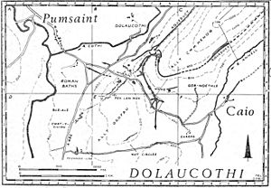
Near the fort, on the east side of the River Cothi, a small building was found. This building had two rooms and a special heating system called a hypocaust. It also had simple tiled floors. This was probably the bath-house for the soldiers.
Over time, the buildings inside the fort were rebuilt several times. The fort was finally left empty around 140 AD. After the soldiers left, a civilian settlement, called a vicus, grew up around the area. These civilians likely took over running the gold mines.
The Luentinum fort was located about halfway between other important Roman forts. These included the fort at Llandovery to the east and Bremia (or Llanio) to the west. The fort at Llandeilo was to the south.
Roman Roads and Connections
Luentinum was a key meeting point for several Roman roads in central Wales.
- The Ffordd Fleming road ran from Luentinum to Menapia (St David's).
- The Via Julia also came from St David's and met the Sarn Helen near Luentinum.
- The Hen Fford (which means "old road") came from Maridunum (Carmarthen).
The Meaning of Luentinum
The name Luentinum is only found in Ptolemy's book, Geographia. Experts believe it comes from an old Brythonic word for 'washing'. This idea was suggested by George Boon from the National Museum of Wales.
This name makes a lot of sense because of how the Romans got gold from the mines. They used a method called hushing, which is a type of hydraulic mining. This involved using water to wash away soil and rock to find the gold. They also used special washing tables to collect the gold dust and small pieces of gold.
The Dolaucothi Gold Mines and the Luentinum fort show how advanced Roman technology was in Britain. This site is very important and can be compared to other famous Roman mines in Europe, like those in Transylvania and Las Médulas in Spain.
 | Toni Morrison |
 | Barack Obama |
 | Martin Luther King Jr. |
 | Ralph Bunche |


