
Luna Peak (Washington) facts for kids
Quick facts for kids Luna Peak |
|
|---|---|
_in_base_of_Luna_Cirque_North_Cascades_Nat._Park_Picket_Range_North_Cascades,_WA.jpg)
Luna Peak far left and Mount Fury at far right
|
|
| Highest point | |
| Elevation | 8,311 ft (2,533 m) NGVD 29 |
| Prominence | 3,105 ft (946 m) |
| Geography | |

Luna Peak
Location in Washington (state)

Luna Peak
Location in the United States
|
|
| Parent range | Picket Range, North Cascades |
| Topo map | USGS Mount Challenger |
| Climbing | |
| First ascent | September 1938, by Bill Cox and Will F. Thompson |
| Easiest route | scramble, (class 3/4) |
Luna Peak is the tallest mountain in the Picket Range. This is a very wild and rugged part of the North Cascades mountains in Washington, USA. It's found inside North Cascades National Park.
Luna Peak stands out because it rises very high from the land around it. It's also quite isolated, meaning it's far from other major peaks. For example, it climbs over 6,560 feet (about 2,000 meters) in just 1.8 miles (about 2.9 kilometers) above McMillan Creek to the south.
The first people to climb Luna Peak were Bill Cox and Will F. Thompson in September 1938. The most common way to climb it is along the Southwest Ridge. You start by going from Ross Lake and Big Beaver Creek. This climb involves tough hiking without clear paths. You might have to push through thick bushes and find your own way. But it's worth it if you like being alone, as not many people climb this peak.
The very last part of the climb to the top involves "scrambling." This means climbing over rocks using both your hands and feet. The rocks can be loose, so some climbing groups might want to use a rope to be safe. This type of climb is often called "Class 3/4" in climbing terms, meaning it's more than just walking but not quite technical rock climbing.
The north and east sides of Luna Peak are very steep and dramatic. However, climbers don't usually choose these faces because they don't offer the kind of challenging rock climbing problems that serious mountaineers look for.
Mountain Weather and Climate
Luna Peak is in a "marine west coast" climate zone. This means it's near the ocean, which affects its weather. Most of the weather systems start over the Pacific Ocean. They then travel northeast towards the Cascade Mountains.
When these weather systems reach the North Cascades, the tall mountains force the air upwards. As the air rises, it cools down and drops its moisture. This causes a lot of rain or snow to fall on the western side of the North Cascades. This process is called "orographic lift."
Because of this, the western side of the North Cascades gets a lot of rain, especially in winter. In winter, it's often cloudy. But in summer, high pressure systems over the Pacific Ocean usually bring clear skies. The snow here tends to be wet and heavy because of the ocean's influence. This can make the risk of avalanches higher.
How the Mountains Were Formed
The North Cascades mountains have some of the roughest land in the entire Cascade Range. You can see sharp peaks, tall spires, long ridges, and deep valleys carved by glaciers. These amazing shapes and big changes in height happened because of geological events that took place millions of years ago. These events also led to the different climates you find across the Cascade Range.
The story of how the Cascade Mountains formed goes back millions of years, to a time called the late Eocene Epoch. At that time, the North American Plate (a huge piece of the Earth's crust) was slowly moving over the Pacific Plate. This movement caused many periods of volcanic activity, where molten rock erupted.
Also, small pieces of the Earth's crust, called "terranes," crashed into North America. These pieces, which came from the ocean floor and other continents, helped build the North Cascades about 50 million years ago.
Later, during the Pleistocene period, which started over two million years ago, huge sheets of ice called glaciers moved across the land. They advanced and retreated many times, scraping and shaping the landscape. You can still see a small piece of a glacier on the south side of Dorado Needle. On the northern side, there's a much larger glacier called the McAllister Glacier.
The river valleys in this area have a "U-shaped" cross section. This shape is a clear sign that glaciers once moved through them. The main forces that created the tall peaks and deep valleys of the North Cascades were the land being pushed upwards (called "uplift") and cracks forming in the Earth's crust (called "faulting"), combined with the powerful work of glaciers.
Images for kids
-
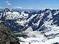
Luna Peak (far left) and Mount Fury (far right) from Lousy Lake.
- Luna Peak photo: Flickr
