Luzerne, Iowa facts for kids
Quick facts for kids
Luzerne, Iowa
|
|
|---|---|

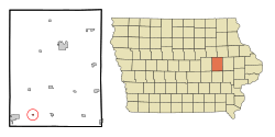
Location of Luzerne, Iowa
|
|
| Country | |
| State | |
| County | Benton |
| Area | |
| • Total | 0.13 sq mi (0.34 km2) |
| • Land | 0.13 sq mi (0.34 km2) |
| • Water | 0.00 sq mi (0.00 km2) |
| Elevation | 938 ft (286 m) |
| Population
(2020)
|
|
| • Total | 112 |
| • Density | 848.48/sq mi (328.04/km2) |
| Time zone | UTC-6 (Central (CST)) |
| • Summer (DST) | UTC-5 (CDT) |
| ZIP code |
52257
|
| Area code(s) | 319 |
| FIPS code | 19-47505 |
| GNIS feature ID | 0464635 |
Luzerne is a small city located in Benton County, Iowa, in the United States. In 2020, about 112 people lived there. It is part of the larger Cedar Rapids area.
Contents
History of Luzerne
Luzerne was started because a new railroad, the Chicago and Northwestern Railway, was being built through the area. In 1868, Isaac B. Howe, who was in charge of the railway's Iowa section, chose the spot and planned out the town. He named it Luzerne, possibly after a town in Switzerland he wanted to visit.
Before Luzerne, there was a train station called "Buckeye" about two miles to the west. In 1867, the railway decided to move that station to an empty spot on the plains, which became Luzerne. This move helped the Chicago & North Western Railway gain more control over the railroad lines.
In 1868, after the new station was set up, Isaac B. Howe bought the land and officially created the town of Luzerne. This happened shortly after the C&NW railway connected with the Union Pacific's Transcontinental Railroad in Council Bluffs. This connection meant Luzerne had a direct link to the Pacific Coast the very next year.
Geography
Luzerne is a small city. According to the United States Census Bureau, the city covers a total area of about 0.12 square miles (0.34 square kilometers). All of this area is land.
Population and People
| Historical populations | ||
|---|---|---|
| Year | Pop. | ±% |
| 1880 | 265 | — |
| 1900 | 169 | −36.2% |
| 1910 | 160 | −5.3% |
| 1920 | 180 | +12.5% |
| 1930 | 149 | −17.2% |
| 1940 | 135 | −9.4% |
| 1950 | 186 | +37.8% |
| 1960 | 136 | −26.9% |
| 1970 | 134 | −1.5% |
| 1980 | 114 | −14.9% |
| 1990 | 110 | −3.5% |
| 2000 | 105 | −4.5% |
| 2010 | 96 | −8.6% |
| 2020 | 112 | +16.7% |
| Source: U.S. Decennial Census | ||
The population of Luzerne has changed over the years. The table above shows how many people have lived there since 1880.
How Many People Live Here? (2020)
In 2020, the census counted 112 people living in Luzerne. There were 31 households and 29 families. This means there were about 849 people per square mile (328 per square kilometer).
Most people living in Luzerne were White (94.6%). A small number were Black or African American (1.8%), and 3.6% were from two or more racial backgrounds. No one identified as Hispanic or Latino in the 2020 census.
- About 48.4% of households had children under 18.
- Most households (71.0%) were married couples living together.
- The average age in Luzerne was 33.0 years.
- About 33.9% of residents were under 20 years old.
- Another 33.9% were between 25 and 44 years old.
- The city had slightly more females (52.7%) than males (47.3%).
Looking Back at 2010
In 2010, there were 96 people living in Luzerne. There were 34 households and 26 families. The population density was about 800 people per square mile (308.9 per square kilometer).
The racial makeup was mostly White (91.7%). There were also some African American residents (2.1%), and 4.2% were from other races. About 5.2% of the population identified as Hispanic or Latino.
- About 47.1% of households had children under 18.
- The average age in the city was 28.5 years.
- About 32.3% of residents were under 18 years old.
- The city had slightly more males (53.1%) than females (46.9%).
See also
 In Spanish: Luzerne (Iowa) para niños

